Llactapata
A ridge-top Inca ruin that looks back at Machu Picchu across the valley
Understand sacred places, explore living traditions, and learn how to engage respectfully with Pilgrim Map.
Access has not been verified. Check current local guidance before planning a visit.
Ollantaytambo district, Cusco, Peru
Read the sources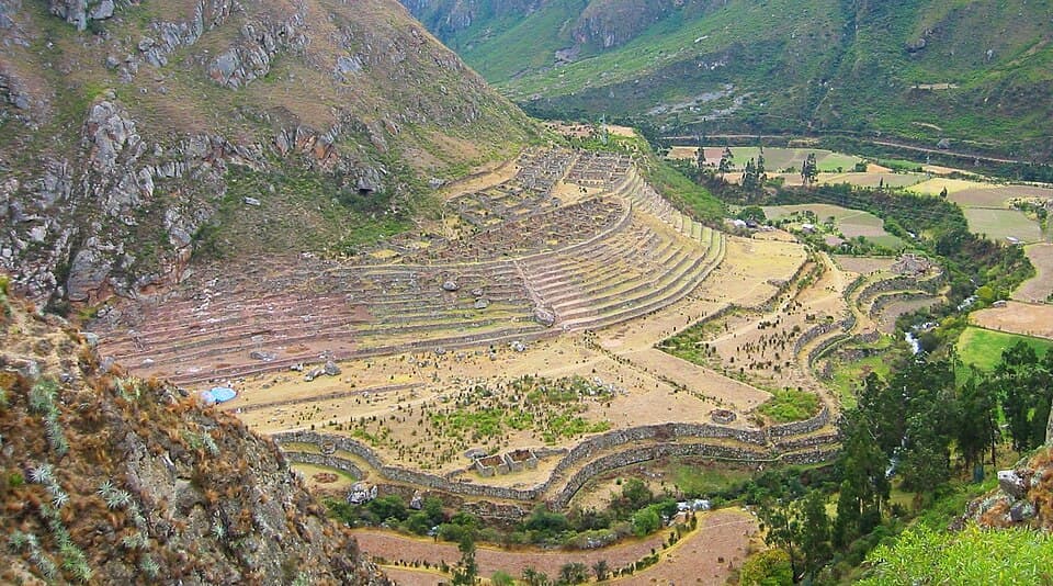
Image of Llactapata. Image source
On this pilgrimage
Inca Trail to Machu PicchuVisit essentials
A quick read before you go
- Duration
- Typically visited as a side trip within a multi-day Salkantay trek or Inca Jungle itinerary…
- Access
- Not reachable via the permit-capped Classic Inca Trail.
Overview
Llactapata occupies a ridge spur roughly five kilometers from Machu Picchu, beyond the Aobamba and Urubamba drainages in today's Santa Teresa District. Hiram Bingham noted the ruins in 1912, but they remained largely unmapped and overgrown until 2003.
That year, explorer Hugh Thomson, mountaineer Gary Ziegler, and archaeoastronomer J. McKim Malville used infrared aerial photography to reveal a plaza and a roughly 145-foot corridor. Its doorways appear aligned toward Machu Picchu and the June solstice sunrise, with other sightlines toward the sacred peaks Salkantay, Veronica, and Pumasillo. The few researchers studying it have not settled whether this indicates a ceremonial-astronomical function, a waystation within Machu Picchu's supporting network, or both.
Visitors use alternate routes rather than the government-regulated Classic Inca Trail, commonly a Salkantay-trek spur or Inca Jungle variant, reaching a comparatively unvisited ruin with an unobstructed view of Machu Picchu across the gorge. The name causes real confusion: a separate, smaller Patallacta at the Cusichaca-Urubamba confluence near the Classic Trail's start is also called Llactapata. This is the ridge-top solstice site studied by Thomson and Malville, not that Patallacta waystation.
Why this place is sacred
The 2003 survey by Hugh Thomson, Gary Ziegler, and J. McKim Malville used infrared aerial imaging to cut through cloud-forest vegetation that had obscured much of the ruin since Bingham's brief 1912 notice. What emerged was a plaza fronted by a long corridor — Thomson records it at roughly 145 feet — whose principal doorways, in his account, frame a sightline toward Machu Picchu and toward the point on the horizon where the sun rises at the June solstice.
Malville's archaeoastronomical training lent the finding scholarly weight, and the site is further positioned along the ridge system that climbs toward Salkantay, one of the most venerated Apus (mountain spirits) in the region, with additional reported sightlines toward Veronica and Pumasillo. Thomson has also compared the plaza's layout to that of the Coricancha, the Inca sun temple in Cusco — an interpretive claim that is his own and has not been independently corroborated by other academic work consulted here.
It is worth holding two things at once: the solstice and Machu Picchu sightlines are reported by the expedition team with some confidence, while the deeper interpretive leap — that Llactapata was purpose-built as an observatory-shrine designed to visually 'complete' Machu Picchu's ceremonial function — rests more heavily on inference and has been amplified with more certainty in tourism writing than in the primary survey material itself.
The Inca state is understood to have built Llactapata as part of the broader network of administrative, agricultural, and ceremonial sites supporting Machu Picchu, probably during the 15th-century imperial period, though no specific ruler's reign is documented in the sources reviewed. Whether its dominant original function was ceremonial-astronomical, a rest and supply waystation, or an integration of both is genuinely unresolved.
After its initial imperial use, Llactapata was abandoned along with the wider Machu Picchu region following the Spanish conquest. It resurfaced in outside written record only briefly with Bingham in 1912, then went essentially undocumented for nine decades until the 2003 Thomson-Ziegler-Malville survey brought it back into scholarly and public attention. It remains unrestored and largely as the surveyors found it, absorbed into the buffer landscape of the Machu Picchu Historic Sanctuary rather than developed as a standalone visitor site.
Experience and orientation
Most visitors arrive at Llactapata as a detour from the Salkantay trek, dropping from Soraypampa or a nearby pass and climbing back up the ridge on foot, or via an Inca Jungle route variant. The approach itself is part of the experience: cloud forest closing in overhead, the trail alternately dry and slick depending on season, and a persistent sense of remove from the tour buses and ticket queues on the other side of the valley.
Arriving at the plaza, there is little interpretive signage and often no one else present — visitors describe the site as one of the more contemplative, exploratory stops in the region precisely because it asks something of the traveler before it gives anything back.
The payoff is the sightline: through the corridor and across the intervening gorge, Machu Picchu appears distant and small, a citadel glimpsed rather than entered, which several trekkers have called one of the best 'secret views' available anywhere near the ruins.
Because the corridor's solstice framing is a documented finding of the 2003 survey rather than folklore, standing in it on or near June 21 carries a different weight than an ordinary overlook — though most visitors will pass through on an ordinary day, and the alignment is not marked or staged for tourism.
The plaza and corridor sit at the high point of the ridge approach; walk the corridor's length toward its open end for the clearest view across the gorge toward Machu Picchu. Vegetation regrowth means visibility varies by season and by how recently the immediate area has been cleared.
Context and lineage
Hiram Bingham passed near the ridge in 1912 during his broader survey of the Machu Picchu region and noted ruins there, but did not investigate closely or record the site in detail. It lay essentially unstudied until November 2003, when Hugh Thomson and Gary Ziegler led an expedition — joined by archaeoastronomer J.
McKim Malville — that used infrared aerial photography to map structures otherwise hidden under cloud-forest canopy, and identified the solstice and Machu Picchu sightlines that gave the site its modern significance. Their findings were announced to the Royal Geographical Society that November and covered in the press, including the Los Angeles Times.
Llactapata belongs to the wider constellation of Inca sites — alongside Choquequirao, Ollantaytambo, and Patallacta — that supported, supplied, or ceremonially framed the royal estate of Machu Picchu, reflecting an imperial landscape in which roads, terraces, and sightlines were woven together with cosmological meaning.
Inca state builders
Original 15th-century construction, as part of the wider network of sites supporting Machu Picchu; no specific ruler or architect is named in sources consulted.
Hiram Bingham
American explorer who briefly noted ruins on this ridge in 1912 during his wider survey of the Machu Picchu region, without close investigation.
Hugh Thomson
British explorer and writer who led the 2003 expedition that mapped and interpreted the site, and who has since written and spoken about it extensively, including comparisons to the Coricancha that remain his own interpretation.
Gary Ziegler
Mountaineer and expedition co-leader on the 2003 survey.
J. McKim Malville
Archaeoastronomer whose analysis identified the corridor's apparent solstice and Machu Picchu sightlines, later elaborated in his book on Llactapata and Choquequirao.
Traditions and practice
If the 2003 survey's reading is accurate, the Inca practices most plausibly associated with this site were solstice sun-observation at the June solstice and veneration of visible sacred peaks (Apus), particularly Salkantay, from the plaza and corridor. No documented account of specific ritual protocol survives, since the site's original name and precise ceremonial use were not recorded in any surviving written source.
There is no organized ceremonial activity at Llactapata today. Some trekking guides may point out the solstice sightline and its Apu associations as they lead groups through, but this is informational rather than ritual.
Approach at a pace slow enough to notice the change in vegetation, light, and sound as the trail climbs the ridge; on arrival, walk the length of the corridor before circling the plaza, and take the time to identify Salkantay and, weather permitting, Machu Picchu across the gorge before moving on.
Inca religion / Andean cosmology
HistoricalLlactapata's plaza and corridor are interpreted by the researchers who surveyed it as reflecting Inca cosmological practice of encoding solar observation and mountain veneration into architecture and sightline, echoing the ceque system radiating from Cusco's Coricancha.
Archaeological and archaeoastronomical research
ActiveSince the 2003 rediscovery, Llactapata has remained a subject of ongoing interpretive interest for archaeoastronomers and Inca-landscape researchers examining sightline and cosmological-design questions across the Machu Picchu region.
Heritage trekking / adventure tourism
ActiveAs an off-Classic-Trail detour on the Salkantay and Inca Jungle routes, Llactapata has become a modest but growing draw for trekkers seeking a quieter, more effortful alternative view of Machu Picchu.
Perspectives and open questions
Interpretations of Llactapata range from a confident astronomical-ceremonial reading advanced by the researchers who mapped it, to a more cautious view that treats the solstice alignment as one plausible function among several within a multi-purpose waystation.
Scholarly perspective
The 2003 survey team (Thomson, Ziegler, Malville) agree the site's plaza and corridor show a deliberate architectural relationship to Machu Picchu and to the June solstice sunrise, situating Llactapata within the broader network of sites supporting the Machu Picchu region.
There is markedly less independent corroboration, outside this same research team's own publications, for Thomson's further claim that the layout was modeled on the Coricancha, or for the precise mechanics of the alignment; that stronger framing should be read as this team's own interpretation rather than settled academic consensus.
Living and traditional perspectives
No site-specific Quechua oral tradition about this Llactapata was located in research. Regional Andean cosmology continues to hold Apu Salkantay, on whose ridge system the site sits, as a major living mountain-spirit deity — a living context for, though not direct documentation of, the site's Inca-era significance.
Alternative interpretations
Popular and tourism-oriented accounts often present Llactapata as proof of sophisticated Inca 'sacred geography' engineering, describing it with more certainty than the primary survey sources allow — treat especially the Coricancha comparison and any claim of a single, settled ceremonial purpose as interpretive framing rather than established fact.
Open questions
The Inca name the site's builders themselves used, its precise original function relative to the network of waystations feeding Machu Picchu, and the extent of structures still concealed by cloud-forest vegetation remain open. Infrared aerial imaging was needed in 2003 precisely because much of the site was still hidden under jungle growth, and no subsequent excavation appears to have settled these questions.
Plan your visit
Access and arrival
Not reachable via the permit-capped Classic Inca Trail. Reached instead via the Salkantay trek (commonly from Soraypampa) or Inca Jungle route variants, which require a separate, smaller local access fee (reported at approximately US$50 by tour operators) rather than the scarce Inca Trail permit, plus the standard Machu Picchu entrance fee if continuing on to the citadel.
No mobile signal information specific to this ridge was available at time of writing; treat the area as having unreliable or no coverage, consistent with other remote sections of the Salkantay and Inca Jungle routes, and carry means of emergency communication provided by your operator. No specific ranger-station or emergency-checkpoint information for this site was available at time of writing; check with your licensed tour operator or Peru's Ministry of Culture for current emergency-access points along your chosen route.
No overnight accommodation exists at the ruin itself; visitors typically camp or stay in trekking-operator lodges along the Salkantay route (e.g., at or near Soraypampa) before and after the detour.
Respectful visit
Layered trekking clothing suited to cloud-forest and high-altitude ridge conditions; no specific dress code is documented.
Personal photography is generally permitted; no site-specific restriction is documented.
Do not touch, climb, or lean on the ancient walls, do not remove stones, and do not mark or disturb any surface, consistent with standard Peruvian archaeological-site regulation.
The detour is physically demanding, requiring sustained ascent at altitude; trekkers with limited high-altitude experience should acclimatize on the main Salkantay route before attempting the side trip, and should not attempt it outside a guided itinerary given limited signage and mobile coverage.
Location
Map loads as you approach this section.
Pilgrim reflections
A portrait of encounter, not a score
Pilgrims describe what they felt, how present they could become, and whether the place would shape a journey. There are no stars and no ranking of traditions.
No reviewed reflections yet
The first pilgrims can help describe the character of being here.
Share a reflection
Available after an account-backed “Been there.” Every reflection is reviewed before publication.
Watch deeper
Films, episodes, and recorded talks for visitors who want more context before or after a visit. Speculative and alternative-history entries are labelled as perspectives, not as sources for established claims.
Nearby sacred places
Explore other sacred places in the region. Proximity does not establish access or travel time; check each place’s guidance.


References
Sources consulted for this page. Source categories describe the publication, not a guarantee that every claim is verified. Traditional accounts and outside interpretations may differ.
- 01Historic Sanctuary of Machu Picchu — UNESCO World Heritage Centre — UNESCOofficialOfficial UNESCO listing confirming the Historic Sanctuary of Machu Picchu (inscribed 1983) covers roughly 35,000+ hectares including surrounding buffer zone terrain in which Llactapata's ridge sits; does not name Llactapata specifically.
- 02State of Conservation (SOC 2011) — Historic Sanctuary of Machu Picchu — UNESCO World Heritage CentreofficialConservation-status reporting on the wider Historic Sanctuary; used for general conservation-pressure context (visitor growth, landslide/flood risk) applicable to the broader area including Llactapata's ridge.
- 03Llaqtapata — Wikipedia — Wikipedia contributorsacademicOverview of location, 1912 Bingham discovery, 2003 Thomson/Ziegler rediscovery and mapping, function theories, naming ambiguity with Patallaqta.
- 04The Rediscovery of Llactapata and its observatory — Hugh ThomsonacademicPrimary first-person account by the expedition leader; describes infra-red camera survey, ceremonial plaza doorways aligned to Machu Picchu, and comparison to Coricancha layout. Personal/independent site, not peer-reviewed, but authored by the principal researcher.
- 05Llactapata — Hugh Thomson (The White Rock site) — Hugh ThomsonacademicSupplementary material from Thomson's expedition archive relating to his book 'The White Rock' on Inca exploration.
- 06L.A. Times Report on Llactapata Discovery — Los Angeles Times (via Hugh Thomson archive)Source contextPress coverage of the November 2003 Royal Geographical Society announcement of the Llactapata findings.
- 07Llactapata: the Re-Discovery of an Inca Site — Field Report — Thomson/Ziegler expedition teamacademicExploration-fund field report on the 2003 expedition; grant-report format rather than peer-reviewed journal, but primary documentation of survey methodology and findings.
- 08A Stairway to Heaven — Ruins with a View — Peruvian TimesSource contextEnglish-language Peru news outlet piece referencing the solstice-aligned corridor at Llactapata pointing toward Machu Picchu; cited via search summary (full fetch blocked by site access restriction).
- 09Patallacta — Wikipedia — Wikipedia contributorsacademicUsed to disambiguate: confirms Patallacta at the Cusichaca/Urubamba confluence near Inca Trail KM 82 is a distinct site sometimes also called 'Llactapata', separate from the Thomson/Malville ridge site covered here.
- 10Llactapata Santa Teresa | Another Way to See Machu Picchu — Salkantay Trek Machu (tour operator)Source contextTour-operator page; used only for corroborating general geography and visitor-access framing, cross-checked against Wikipedia/Thomson sources.
- 11How to Interpret the Astronomical Alignments at Machu Picchu — machupicchu.orgSource contextGeneral-audience site used for corroborating broader Inca solstice/astronomy framing around Machu Picchu; not Llactapata-specific but supports cosmological context (Intihuatana alignment toward Salkantay).
Share a photo
Help visitors recognize Llactapata. Every submission is reviewed before publication.