Knowe of Lairo
A Neolithic long cairn remodelled in antiquity, standing on the hillside above Eynhallow Sound where fifteen tombs mark one island's relationship with the dead
Rousay, Orkney Islands, United Kingdom

Plan this visit
Practical context before you go
Two to three hours to combine with walks to the neighbouring Knowes of Ramsay and Yarso.
Rousay is reached by ferry from Tingwall on Mainland Orkney (approximately thirty minutes). The Knowe of Lairo is located in the Frotoft area on Rousay's southwestern coast. OS grid reference: HY 3988 2796. GPS: approximately 59.1341 N, 3.0530 W. No formal car park; visitors walk from the coastal road. The terrain is uneven hillside grassland.
The Knowe of Lairo is a scheduled ancient monument on private land. Visitors should seek landowner permission, remain outside the cairn structure, and take standard precautions for walking on exposed Orkney hillside.
At a glance
- Coordinates
- 59.1341, -3.0530
- Type
- Chambered Cairn
- Suggested duration
- Two to three hours to combine with walks to the neighbouring Knowes of Ramsay and Yarso.
- Access
- Rousay is reached by ferry from Tingwall on Mainland Orkney (approximately thirty minutes). The Knowe of Lairo is located in the Frotoft area on Rousay's southwestern coast. OS grid reference: HY 3988 2796. GPS: approximately 59.1341 N, 3.0530 W. No formal car park; visitors walk from the coastal road. The terrain is uneven hillside grassland.
Pilgrim tips
- Sturdy walking boots and waterproof clothing are essential. The site is fully exposed to Orkney weather.
- Exterior photography is unrestricted. The panoramic setting above Eynhallow Sound offers excellent landscape photography opportunities.
- The cairn is on private land. Permission from the landowner should be sought before visiting. Do not attempt to enter the chamber, as the interior is structurally fragile. The terrain is uneven hillside grassland.
Overview
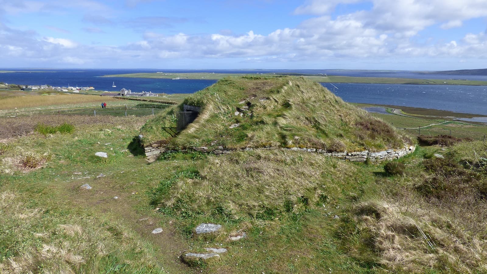
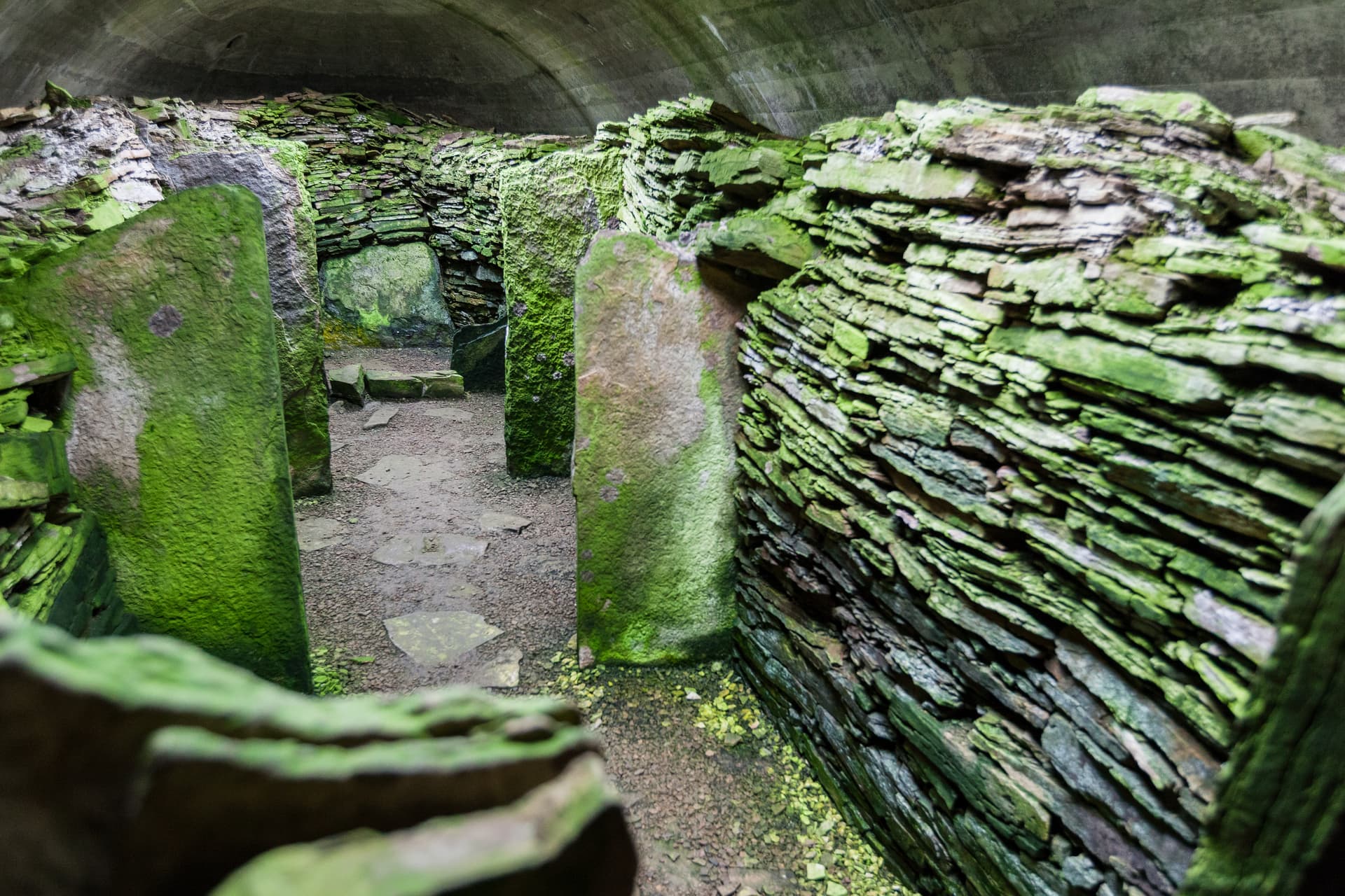
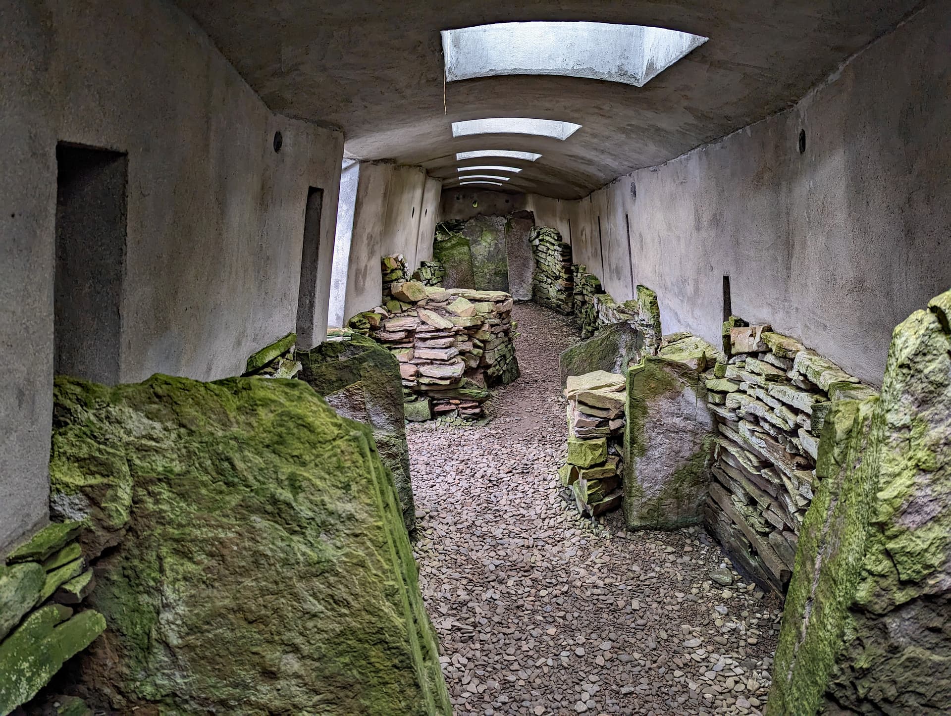
On the southwestern hillside of Rousay, overlooking Eynhallow Sound and the tidal island whose Norse name means Holy Island, the Knowe of Lairo stretches over forty-five metres across the slope. This long horned cairn was built during the early Neolithic period and then substantially remodelled, possibly in an attempt to transform a stalled cairn into something resembling the passage graves found elsewhere in Orkney. The remodelling created an interior chamber of extraordinary proportions: over four metres high but narrowing to just fifty centimetres at the top. Whether this represents an unfinished conversion or an intentional architectural form remains debated.
Rousay earned the name the Egypt of the North for its remarkable concentration of Neolithic chambered cairns, at least fifteen on an island barely five miles across. The Knowe of Lairo is among the most architecturally complex of these, its building history reflecting not one moment of construction but an extended conversation between generations about how the dead should be housed.
The cairn was initially built as an Orkney-Cromarty type long horned cairn, with projecting horn-works at both ends and a stalled internal chamber divided into compartments. This form is characteristic of the region's early Neolithic communities. But at some point during its period of use, the cairn underwent dramatic remodelling. Additional walling was inserted into the original chamber, creating a passage that rises to over four metres in height while narrowing to a slit barely fifty centimetres wide at the top.
Archaeologists J.L. Davidson and Audrey Henshall proposed in 1989 that this remodelling represented a tentative attempt to convert the stalled cairn into a Maeshowe-type passage grave, a more sophisticated tomb design found at the famous Maeshowe on Mainland Orkney. Other scholars have questioned this interpretation, suggesting the modifications may represent something entirely different. The debate remains unresolved, adding a layer of genuine mystery to the site.
The 1936 excavation by Walter Grant recovered the remains of at least two adult males, along with grave goods including a polished stone axe, pottery sherds, a flint knife, and animal bones. The excavation was only partially published, a summary appearing in 1943, meaning that details of the finds and their precise contexts may be incomplete.
The cairn's position on the hillside creates intervisibility with the neighbouring Knowes of Ramsay and Yarso, suggesting deliberate placement within a ritual landscape where the dead of different communities, or different periods, could watch over one another across the slopes.
Context and lineage
The Neolithic communities who built the Knowe of Lairo left no written records. The cairn's construction within a cluster of cairns on Rousay's southwestern coast suggests deliberate placement within a ritual landscape. The intervisibility between Lairo and neighbouring cairns indicates that these monuments were conceived not in isolation but in relationship to one another. The cairn's name derives from Old Norse, reflecting the later Viking-era settlement of Orkney, and carries no Neolithic significance.
No continuous tradition connects the present to the Neolithic builders. The cairn passed through millennia of abandonment before archaeological recovery in the 1930s. Its significance today is primarily archaeological and contemplative.
Walter Grant
J.L. Davidson and Audrey Henshall
Why this place is sacred
Thin places often emerge where deliberate human intention meets the particular qualities of a landscape. The Knowe of Lairo occupies such a convergence. The hillside terrace above Eynhallow Sound places the cairn at the boundary between land and sea. The views across the sound to Mainland Orkney and the tidal island of Eynhallow, whose name derives from Old Norse Eyin Helga meaning Holy Island, suggest an area perceived as sacred across millennia.
The cairn's remodelled interior amplifies the liminal quality. The original stalled chamber, with its compartmented burial spaces, was transformed into something more dramatic: a passage rising to over four metres but closing to a narrow slit overhead. To enter such a space by torchlight would have been to experience a visceral passage from the everyday world into something other. Whether this was intentional or an artefact of incomplete reconstruction, the effect would have been powerful.
The clustering of cairns on this stretch of coast intensifies the sense of a landscape saturated with ancestral presence. Standing beside Lairo, you can see the locations of the Knowes of Ramsay and Yarso, each housing its own community of the dead. The Neolithic people of Rousay did not scatter their tombs randomly. They placed them in relationship with one another, creating a geography of death that structured the living landscape.
The passage of five thousand years has softened the cairn into a grassy mound, but its scale remains impressive. Over forty-five metres long, it dominates the hillside. The horn-works at either end create shallow forecourt spaces where the living may have gathered for ceremony. The site resists easy interpretation, which is itself a quality of thinness: the mystery of what happened here cannot be fully resolved, only contemplated.
The cairn served as a communal burial monument for Neolithic farming communities. Skeletal remains, grave goods, and the stalled interior all point to a funerary function consistent with other Orkney-Cromarty cairns. The subsequent remodelling suggests evolving ritual needs or changing architectural ideals, possibly reflecting contact with the communities that built the Maeshowe-type passage graves.
Construction during the early Neolithic period, approximately 3600 to 3200 BCE. Substantial remodelling occurred during the cairn's active use, creating the unusually tall and narrow chamber. Walter Grant excavated in 1936, publishing a summary in 1943. The site is now a scheduled ancient monument under Scottish heritage protection, though it remains on private land.
Traditions and practice
Neolithic burial practices involved communal interment within the stalled compartments. Skeletal remains were placed with grave goods including a polished stone axe, pottery, a flint knife, and animal bones. The multi-compartment design suggests organised placement, possibly reflecting social structure or family groupings. The remodelling of the chamber during active use points to evolving ritual requirements.
No active spiritual practices are maintained at the site. The cairn is visited as part of the broader Rousay archaeological landscape. The Tombs of the Isles project by Archaeology Orkney has conducted recent survey and 3D modelling work.
The exterior of the cairn rewards careful observation. Trace the full length of the mound and identify the horn-works at either end. Consider the intervisibility with the neighbouring cairns of Ramsay and Yarso. The 3D model available online offers insight into the extraordinary remodelled interior.
Neolithic Orkney-Cromarty Cairn Tradition
HistoricalThe Knowe of Lairo belongs to the Orkney-Cromarty group of chambered cairns, a distinctive Neolithic funerary tradition. Its long horned form, stalled interior, and communal burial practices are characteristic of the tradition. The cairn's unique remodelling suggests evolving ritual ambitions within this architectural framework.
Communal burial within compartmented chambers. Grave goods including stone tools, pottery, and animal bones were deposited with the dead. The cairn's design allowed repeated access for successive burials. The remodelling of the interior may reflect changing beliefs about how the dead should be housed.
Experience and perspectives
Approaching the Knowe of Lairo from the coastal road, you climb gently across open hillside. The cairn reveals itself gradually, its elongated form stretching across the slope like a beached vessel. Grass covers the mound now, softening its contours, but the sheer length impresses. This was not a modest burial place. It was a statement.
The horn-works at either end of the cairn create concave forecourt spaces, architectural features that likely served a gathering function. Standing in these spaces, you face the cairn's flanks, which rise to over four metres at the highest point. The scale is comprehensible at human proportions but just beyond it, large enough to inspire, intimate enough to feel personal.
The views from the site are integral to the experience. Eynhallow Sound spreads below, its tidal currents visible on the surface. The island of Eynhallow, uninhabited now, sits in the middle distance. Mainland Orkney rises beyond. On clear days, the intervisibility between Lairo and the neighbouring cairns of Ramsay and Yarso is apparent, each tomb occupying its own terrace on the slope.
Interior access is no longer permitted due to structural fragility, a loss given that the remodelled chamber, rising over four metres to a narrow slit, was described by those who entered it as one of the most remarkable features of any Orcadian cairn. However, a 3D photogrammetric model by Dr Hugo Anderson-Whymark, available online, offers virtual exploration of the cairn's form.
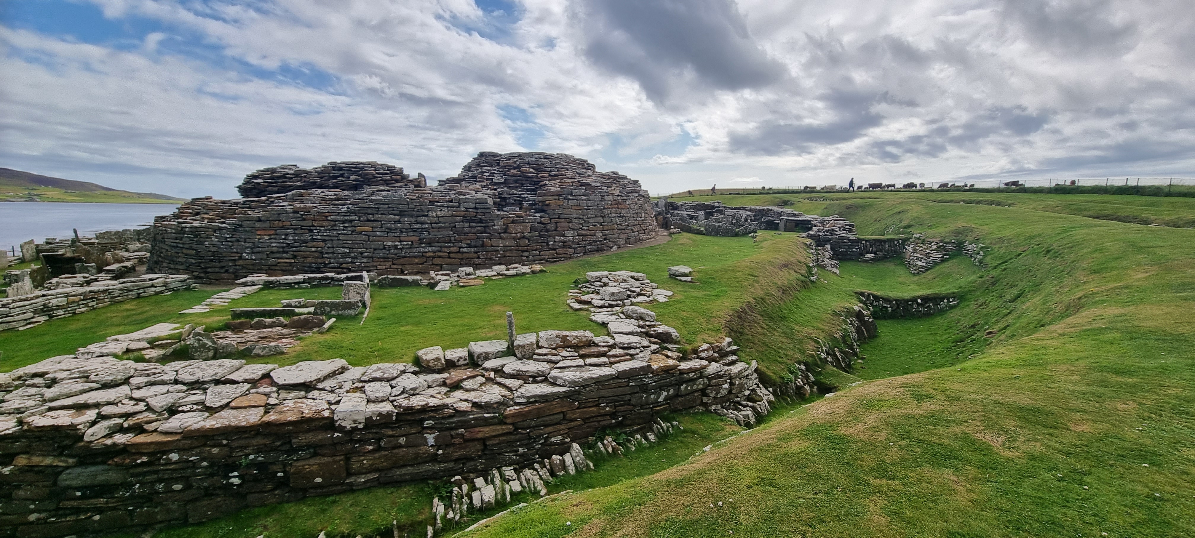
The experience at Lairo is quieter and more solitary than at the sheltered sites of Midhowe or Blackhammer. Without a protective building or elevated walkway, you engage with the cairn as a feature of the landscape, reading its form against the hillside and the sea beyond.
The Knowe of Lairo is located on the southwestern coast of Rousay, in the Frotoft area east of Hullion. It is reached on foot from the coastal road. Most visitors combine it with walks to the neighbouring Knowes of Ramsay and Yarso. Rousay is reached by ferry from Tingwall on Mainland Orkney.
The Knowe of Lairo invites interpretation but resists certainty. Its complex architectural history, a stalled cairn dramatically remodelled during its period of use, raises questions that five thousand years of silence cannot answer.
Archaeologists recognise the Knowe of Lairo as an important example of an Orkney-Cromarty type long horned cairn from the early Neolithic period, approximately 3600 to 3200 BCE. The cairn underwent significant remodelling during its period of active use, with the original stalled chamber modified by additional walling to create an unusually tall (4.2 metres) and narrow chamber. Davidson and Henshall's 1989 publication proposed that this remodelling was an attempt to convert the structure to emulate a Maeshowe-type passage grave, though this interpretation remains debated. Grant's 1936 excavation recovered remains of at least two adult males with grave goods. The site is part of Rousay's remarkable concentration of fifteen Neolithic chambered cairns.
No oral tradition survives from the Neolithic builders. The cairn's name derives from Old Norse and preserves no Neolithic memory. The beliefs and practices of those who constructed and used the tomb are irrecoverable through any means other than archaeological inference.
Some visitors interested in megalithic sites interpret the extraordinary height of Lairo's remodelled chamber as designed for visionary experience, the darkness, enclosure, and extreme proportions facilitating altered states of consciousness. The intervisibility between Rousay's cairns has attracted interest from those who perceive deliberate alignment patterns. These interpretations cannot be verified from the archaeological evidence.
The purpose of the dramatic remodelling remains the central mystery. Whether the original stalled cairn was completed before modifications began is uncertain. The 1936 excavation was only partially published, and details of finds and contexts may be incomplete. Why Rousay holds such an extraordinary concentration of cairns compared to other Orkney islands remains an open question.
Visit planning
Rousay is reached by ferry from Tingwall on Mainland Orkney (approximately thirty minutes). The Knowe of Lairo is located in the Frotoft area on Rousay's southwestern coast. OS grid reference: HY 3988 2796. GPS: approximately 59.1341 N, 3.0530 W. No formal car park; visitors walk from the coastal road. The terrain is uneven hillside grassland.
Limited accommodation on Rousay. More options in Kirkwall on Mainland Orkney.
The Knowe of Lairo is a scheduled ancient monument on private land. Visitors should seek landowner permission, remain outside the cairn structure, and take standard precautions for walking on exposed Orkney hillside.
Sturdy walking boots and waterproof clothing are essential. The site is fully exposed to Orkney weather.
Exterior photography is unrestricted. The panoramic setting above Eynhallow Sound offers excellent landscape photography opportunities.
Not appropriate at an archaeological monument.
Do not enter the chamber. Do not climb on the cairn structure. Do not remove any material. Seek landowner permission before visiting.
Plan your visit
Address
island of Rousay, Orkney KW17 2PT, UK
Hours, fees, and access can change — verify on the official source before you travel. Practical details last checked Jun 2026.
Nearby sacred places
Sacred places within a half-day’s reach. Pilgrims often visit them together: walk one, stay for the other.
References
Sources consulted when researching this page. Independent verification by readers is welcome.
- 01Knowe of Lairo, Rousay - Archaeology Orkney — Archaeology Orkney / Sigurd Towriehigh-reliability
- 02The Knowe of Lairo - remodelled to emulate Maeshowe or something completely different? — Ness of Brodgarhigh-reliability
- 03The Knowe of Lairo, Rousay, Orkney: With a note on the relics — W. G. Granthigh-reliability
- 04Knowe of Lairo, long cairn, east of Hullion, Frotoft - Ancient Monuments — Ancient Monuments UKhigh-reliability
- 05Tombs of the Isles - the Knowe of Lairo, Rousay - Update — Archaeology Orkneyhigh-reliability
- 06Knowe of Lairo Long Horned Cairn, Rousay - 3D Model — Dr Hugo Anderson-Whymarkhigh-reliability
- 07Knowe of Lairo Chambered Cairn - The Megalithic Portal — The Megalithic Portal
- 08Knowe of Lairo - Rousay Remembered — Rousay Remembered
Key questions
What pilgrims usually ask
- Why is Knowe of Lairo considered sacred?
- Visit the Knowe of Lairo, a Neolithic long horned cairn on Rousay, Orkney. Over 45 metres long with a dramatically remodelled interior, part of Orkney's richest
- What should I wear at Knowe of Lairo?
- Sturdy walking boots and waterproof clothing are essential. The site is fully exposed to Orkney weather.
- Can I take photos at Knowe of Lairo?
- Exterior photography is unrestricted. The panoramic setting above Eynhallow Sound offers excellent landscape photography opportunities.
- How long should I spend at Knowe of Lairo?
- Two to three hours to combine with walks to the neighbouring Knowes of Ramsay and Yarso.
- How do you visit Knowe of Lairo?
- Rousay is reached by ferry from Tingwall on Mainland Orkney (approximately thirty minutes). The Knowe of Lairo is located in the Frotoft area on Rousay's southwestern coast. OS grid reference: HY 3988 2796. GPS: approximately 59.1341 N, 3.0530 W. No formal car park; visitors walk from the coastal road. The terrain is uneven hillside grassland.
- What offerings are appropriate at Knowe of Lairo?
- Not appropriate at an archaeological monument.
- What etiquette should visitors follow at Knowe of Lairo?
- The Knowe of Lairo is a scheduled ancient monument on private land. Visitors should seek landowner permission, remain outside the cairn structure, and take standard precautions for walking on exposed Orkney hillside.
- What is the history of Knowe of Lairo?
- The Neolithic communities who built the Knowe of Lairo left no written records. The cairn's construction within a cluster of cairns on Rousay's southwestern coast suggests deliberate placement within a ritual landscape. The intervisibility between Lairo and neighbouring cairns indicates that these monuments were conceived not in isolation but in relationship to one another. The cairn's name derives from Old Norse, reflecting the later Viking-era settlement of Orkney, and carries no Neolithic significance.