Karabel Relief
The last Hittite monument in western Anatolia, carved to sanctify a mountain pass between worlds
Kemalpaşa–Torbalı corridor, İzmir, Aegean Region, Turkey
Plan this visit
Practical context before you go
1–2 hours at the site including travel within the pass area. Allow additional drive time from İzmir (approximately 30–40 minutes).
Located in the Karabel Pass between Torbalı and Kemalpaşa, approximately 20 km southeast of İzmir city center, beside the D550/E87 road. Approach by private vehicle — there is no public transport to the relief itself. Roadside parking is informal. GPS: approximately 38.3706°N, 27.4561°E. No visitor facilities, no signage, no admission fee.
An open-air archaeological site with no active religious community; treat with the care owed to fragile and irreplaceable carved stone.
At a glance
- Coordinates
- 38.3706, 27.4561
- Type
- Hittite Rock Relief
- Suggested duration
- 1–2 hours at the site including travel within the pass area. Allow additional drive time from İzmir (approximately 30–40 minutes).
- Access
- Located in the Karabel Pass between Torbalı and Kemalpaşa, approximately 20 km southeast of İzmir city center, beside the D550/E87 road. Approach by private vehicle — there is no public transport to the relief itself. Roadside parking is informal. GPS: approximately 38.3706°N, 27.4561°E. No visitor facilities, no signage, no admission fee.
Pilgrim tips
- No specific requirements. Practical clothing for outdoor walking on rocky terrain beside a road.
- Photography permitted and encouraged for documentation. The northwest-facing surface is best photographed in morning light or on overcast days when shadows are reduced.
- Do not touch the carved surface. The relief is exposed to weathering and requires careful management. Road traffic is ongoing beside the site — be cautious when stopping. There are no visitor facilities.
Overview
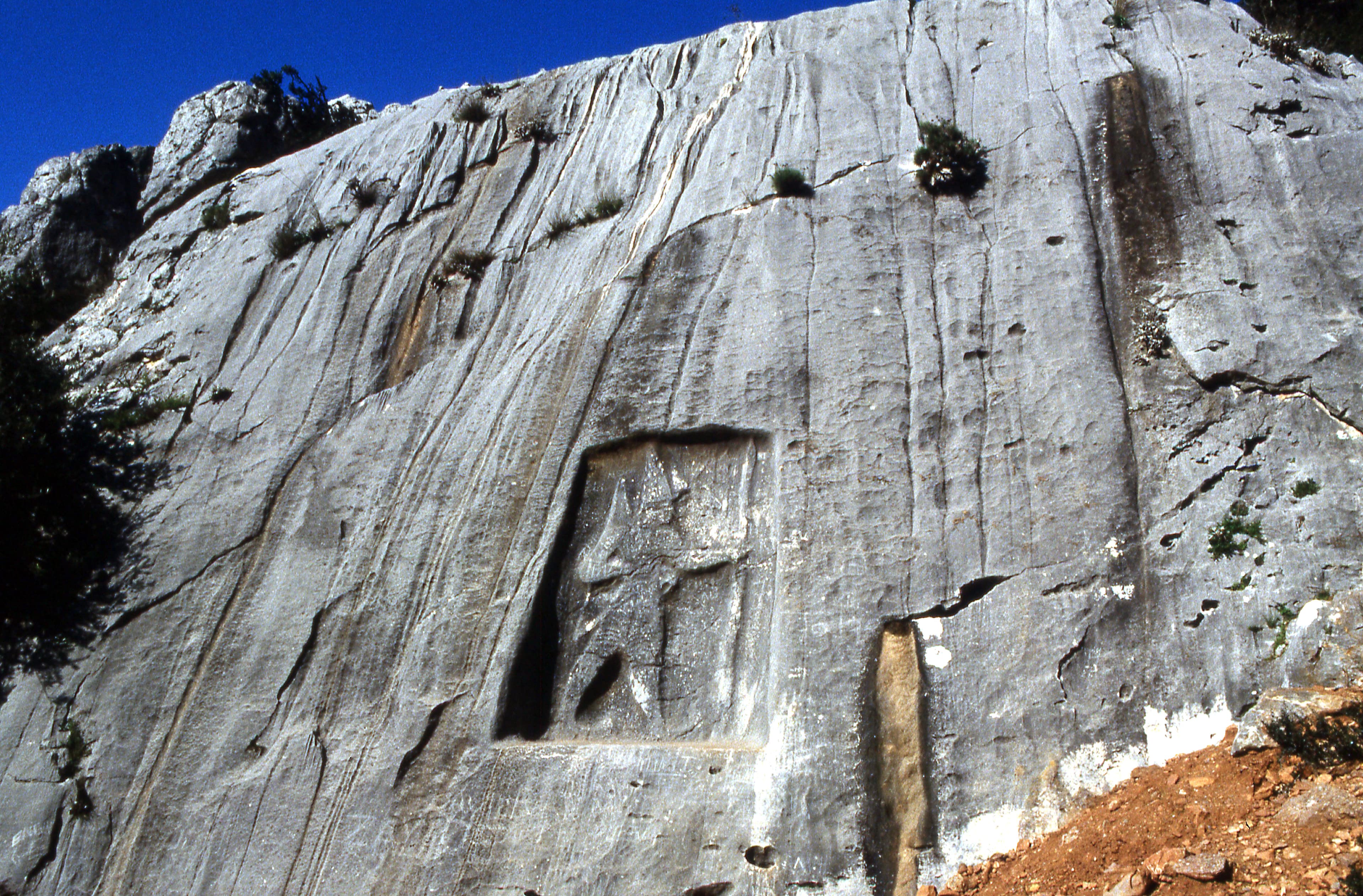
A rock relief carved three millennia ago by a Hittite vassal king watches over the Karabel Pass in the hills east of İzmir. Of the four components of the original monument, three were destroyed by road construction in the 1970s and 80s. What remains — a single carved figure of Tarkasnawa, king of Mira, bearing bow and spear in a pointed conical cap — is the westernmost surviving testimony of the Hittite world.
In the Karabel Pass between the Aegean coast and the Anatolian interior, a cliff face bears the image of a man who ruled three thousand years ago. Tarkasnawa, king of Mira and vassal of the Hittite Empire, had himself carved here in the final decades of Hittite civilization — a standing figure in a conical hat, holding bow and spear, his name recorded beside him in Luwian hieroglyphics. The pass was a threshold between coastal and highland Anatolia, between the Greek world and the deep interior. For the Hittites, such thresholds were charged with meaning: mountain passes were liminal zones where divine protection was most necessary and most potently invoked.
The inscription proved pivotal in deciphering the Luwian script and anchoring Hittite civilization in Anatolia rather than Syria, where earlier scholarship had placed it. Herodotus had passed through this same corridor and recorded the figure as Egyptian — a misidentification that stood for centuries. The truth was more ancient and more local: this was a Bronze Age king asserting sovereignty at the edge of a world that would collapse within a generation of the carving.
Three of the original four relief components were destroyed when road construction blasted through the pass in 1977–1982. What stands is Karabel A — worn but intact, the sole survivor of a vanished civilization's westernmost reach. To stand before it is to encounter the limit of the Hittite world, held in stone at the pass where that world met its edge.
Context and lineage
In the late 13th century BCE — approximately 1220–1180 BCE — the Hittite Empire was at the height of its reach but within a generation of catastrophic collapse. Tarkasnawa, king of Mira, ruled a vassal state in western Anatolia under the Hittite Great King. The Karabel Pass, linking the Aegean coastal plain with the Anatolian interior, was a vital corridor for trade, military movement, and administrative contact between western Anatolia and the Hittite heartland.
Hittite practice held that mountain pass entrances should be consecrated with royal or divine imagery — a combination of territorial claim and religious act. Tarkasnawa had himself carved at Karabel in the canonical style: a standing figure in a conical cap (symbol of divine authority), holding bow and spear (symbols of military power), with his name and titles rendered in Luwian hieroglyphics on the adjacent rock face. Originally, the monument comprised four components: Karabel A (the standing figure), Karabel B, and two inscription panels C1 and C2. Together they created a monumental gateway to western Anatolia under Hittite vassal authority.
Within a generation of the carving, the Hittite Empire collapsed — around 1180 BCE — as part of the broader Bronze Age collapse that destroyed multiple Eastern Mediterranean civilizations simultaneously. Tarkasnawa's world ended. The reliefs remained, witnessed by travelers for three thousand years, until modern road construction destroyed three of the four components between 1977 and 1982.
The relief belongs to a broader Hittite tradition of rock carving at mountain passes — a tradition documented from western Anatolia (Karabel) through the Taurus Mountains (Fıraktın, İmamkullu, Hanyeri, Taşçı) to the Hittite heartland. The practice was not purely political but carried religious weight: the carved figure invoked divine protection over the pass and its travelers.
Tarkasnawa
King of Mira, Hittite vassal ruler who commissioned and is depicted in the relief
Herodotus
Ancient Greek historian who recorded the figure as Egyptian in his travels through the region — a misidentification that influenced scholarship for centuries
Why this place is sacred
Mountain passes in Hittite sacred geography were not incidental corridors but charged thresholds — zones between territories, between lowland and highland, between the familiar and the unknown. The king's image at a pass entrance was simultaneously political statement and religious act: the carved figure invoked divine protection for travelers, declared royal sovereignty over the passage, and anchored the king's presence permanently in stone at the place where his authority was most needed.
Karabel's thinness operates across multiple registers. Geographically, the pass marks where the Aegean world ends and the Anatolian interior begins — a boundary felt in the landscape itself. Historically, it was carved at the edge of Hittite civilization's westernmost extension, in the final decades before the empire's collapse around 1180 BCE. The survival of Karabel A after the destruction of its companions intensifies this sense: one figure remaining against three losses, itself in need of rescue, carries the full weight of a vanished world's reach into the present.
The figure's conical hat aligns Tarkasnawa symbolically with divine authority — the same headgear worn by Hittite gods in canonical iconography. The king was not merely passing through; he was invoking the divine order of which he was a part, marking the pass as a place where heaven and earth negotiated.
Territorial and religious legitimation: to assert Tarkasnawa's authority over the Karabel Pass as a Hittite vassal, invoke divine protection for those passing through, and mark the boundary of Hittite influence at its westernmost reach.
The monument's meaning has shifted dramatically over millennia. For Herodotus and classical antiquity it was inexplicable — assumed Egyptian. For Ottoman and early modern scholarship it was mysterious. For 19th and 20th century archaeologists it became a key to deciphering Luwian hieroglyphics and locating Hittite civilization. Today it stands as a conservation concern: the sole survivor of a four-part monument, exposed to weathering and road traffic, awaiting formal protection.
Traditions and practice
In Hittite religious practice, mountain pass reliefs were acts of consecration as much as territorial assertion. The carved king's image — wearing the conical cap that aligned the ruler symbolically with divinity — invoked the gods' protection over the pass and its travelers. The act of carving was itself a ritual: the king's presence, rendered permanent in stone, ensured ongoing divine sanction of the route. No specific ceremonies at Karabel are recorded, but the broader Hittite practice at comparable sites included libations, invocations, and royal ritual enactment at the carved surfaces.
No active practices. The site receives occasional visits from archaeologists, students of Hittite civilization, and heritage tourists, but no organized program of any kind.
Arrive on foot from the road, moving slowly toward the cliff face. Allow the relief to become legible gradually rather than searching for detail from a distance. Face the carved figure at its own level — the conical hat, the held weapon, the inscription at its side — and consider that this was the westernmost carving of a civilization's official self-presentation. The hieroglyphic inscription beside the figure was one of the texts that unlocked the Luwian script: these marks translated a lost language back into history.
Turn and look outward from the relief, as Tarkasnawa's image has looked for three thousand years: northwest toward the Aegean plain, the coastal world, the edge of the empire. Then consider what is not visible — the three companion sections of this monument, destroyed in living memory. The empty rock on either side of the surviving figure is not blank: it is a record of loss. Holding that awareness — the monument's survival and its mutilation, both — gives the encounter its full weight.
Hittite Royal Cult / Luwian Heritage
HistoricalThe relief was carved to assert royal authority and divine favor of Tarkasnawa, king of the Hittite vassal state of Mira, in a strategically vital mountain pass connecting inland Anatolia with the Aegean coast. It served as a monumental marker of royal presence and legitimacy along a major trade and military route.
Carving rock reliefs at pass entrances was a Hittite practice to declare territorial control and invoke divine protection for the pass and its travelers.
Archaeological / Scholarly
ActiveThe Luwian hieroglyphic inscription was pivotal in deciphering the script and establishing that Hittite civilization was centered in Anatolia rather than Syria. The relief remains a primary reference point for Hittite studies in western Anatolia.
Site visits by epigraphers and archaeologists; casts held at İzmir museum and referenced in international publications.
Experience and perspectives
The Karabel Pass is not a dramatic gorge — it is a low saddle in the hills between Torbalı and Kemalpaşa, crossed by a road that has been in use, in various forms, for at least three millennia. The relief appears beside that road, carved into a cliff face that is easy to drive past without noticing. The figure measures roughly 1.5 meters wide by 2.5 meters high — substantial but not monumental by modern standards. What strikes those who stop is the state of aloneness: a single carved figure in a weathered rock face, no signs, no facilities, no companions.
Approach on foot from the road side, where the figure faces you at roughly eye level. Give yourself time to allow the carving to become legible — the conical hat, the held bow and spear, the hieroglyphic inscription to the right. The weathering is real; some details require patience and angled light to read. Morning light, falling at an angle across the northwest-facing surface, helps articulate the low relief.
Consider what is missing. Three other sections of this monument were destroyed within living memory — blasted away by road construction between 1977 and 1982. The space around Karabel A is not empty landscape; it is a graveyard of lost carving. Sitting with that absence — the three companions gone, this one survived by proximity or chance — is part of what the site offers. The Hittite Empire itself collapsed within a generation of this relief being carved. To stand here is to stand at the edge of a world that did not know it was ending.
The relief is carved into a cliff face in the Karabel Pass between Torbalı and Kemalpaşa, approximately 20 km southeast of İzmir city center, beside the D550/E87 road. It faces northwest. No signage or formal parking. The best approach is by car with a cautious roadside stop, followed by a short walk to the rock face.
The Karabel relief is read differently depending on what kind of presence one is bringing to the encounter: epigraphic evidence, political history, the felt weight of deep time, or the question of what survives and what doesn't.
The scholarly consensus places the relief in the late 13th century BCE, carved by Tarkasnawa of Mira, a Hittite vassal kingdom in western Anatolia. The Luwian hieroglyphic inscription was crucial in establishing both Tarkasnawa's identity and the decipherment of Luwian script itself. The relief also confirmed that Hittite civilization extended well into western Anatolia — correcting earlier assumptions, influenced by Herodotus' misidentification, that Hittite territory was limited to central and eastern Anatolia. Peer-reviewed scholarship (Cambridge Archaeological Journal, European Journal of Archaeology) has examined the monument's changing cultural significance and its role in Orientalist historiography of the 19th and 20th centuries.
No living tradition is directly associated with the site. The region is part of the Turkish-speaking world, and the monument sits within a landscape of contemporary agricultural and road infrastructure. No Hittite descendant community maintains the site.
From a liminal landscape perspective, the Karabel Pass can be understood as a persistent threshold — a place where different worlds have met, merged, and separated across several millennia. The Hittite practice of carving a king at a pass entrance acknowledges what passes actually are: thresholds where the familiar ends and the unknown begins, where divine protection is most needed. The relief's survival — one figure from four, at the edge of a collapsed empire — can be read as a kind of stubborn presence, the carved stone outlasting the civilization that made it by three thousand years.
The full political relationship between Tarkasnawa and the late Hittite Great King remains uncertain. Questions persist about whether additional reliefs existed in the broader Karabel corridor beyond the four documented components, and about the religious program — if any — enacted at the carved surface during the Hittite period.
Visit planning
Located in the Karabel Pass between Torbalı and Kemalpaşa, approximately 20 km southeast of İzmir city center, beside the D550/E87 road. Approach by private vehicle — there is no public transport to the relief itself. Roadside parking is informal. GPS: approximately 38.3706°N, 27.4561°E. No visitor facilities, no signage, no admission fee.
İzmir city center (20 km northwest) offers a full range of accommodation. No facilities near the pass itself.
An open-air archaeological site with no active religious community; treat with the care owed to fragile and irreplaceable carved stone.
No specific requirements. Practical clothing for outdoor walking on rocky terrain beside a road.
Photography permitted and encouraged for documentation. The northwest-facing surface is best photographed in morning light or on overcast days when shadows are reduced.
None appropriate. This is an archaeological site with no active religious practice.
Do not touch or mark the carved surface. Do not attempt to climb the cliff face. Exercise caution beside the road.
Nearby sacred places
Sacred places within a half-day’s reach. Pilgrims often visit them together: walk one, stay for the other.


References
Sources consulted when researching this page. Independent verification by readers is welcome.
- 01Metamorphoses of a Monument: The Materializations of the Karabel Relief (Turkey) — Cambridge Core / European Journal of Archaeologyhigh-reliability
- 02Vandalizing Father Hittite: Karabel, Orientalism and Historiographies — Cambridge Archaeological Journalhigh-reliability
- 03Karabel relief - Wikipedia — Wikipedia contributors
- 04Alone Against Time: The 3,000-Year-Old Last Hittite Monument of Western Anatolia Awaits Rescue — Arkeonews
- 05Forgotten Hittite Legacy in İzmir: Karabel Rock Monument Cries for Help — Anatolian Archaeology
- 06Herodotus' Error: Misreading the Hittite 'Karabel Rock Relief' as Egyptian — The Archaeologist
- 07Karabel Relief | Archiqoo — Archiqoo
Key questions
What pilgrims usually ask
- Why is Karabel Relief considered sacred?
- Carved by Tarkasnawa of Mira c. 1220–1180 BCE, the Karabel Relief marks the Hittite world's westernmost edge in a mountain pass east of İzmir.
- What should I wear at Karabel Relief?
- No specific requirements. Practical clothing for outdoor walking on rocky terrain beside a road.
- Can I take photos at Karabel Relief?
- Photography permitted and encouraged for documentation. The northwest-facing surface is best photographed in morning light or on overcast days when shadows are reduced.
- How long should I spend at Karabel Relief?
- 1–2 hours at the site including travel within the pass area. Allow additional drive time from İzmir (approximately 30–40 minutes).
- How do you visit Karabel Relief?
- Located in the Karabel Pass between Torbalı and Kemalpaşa, approximately 20 km southeast of İzmir city center, beside the D550/E87 road. Approach by private vehicle — there is no public transport to the relief itself. Roadside parking is informal. GPS: approximately 38.3706°N, 27.4561°E. No visitor facilities, no signage, no admission fee.
- What offerings are appropriate at Karabel Relief?
- None appropriate. This is an archaeological site with no active religious practice.
- What etiquette should visitors follow at Karabel Relief?
- An open-air archaeological site with no active religious community; treat with the care owed to fragile and irreplaceable carved stone.
- What is the history of Karabel Relief?
- In the late 13th century BCE — approximately 1220–1180 BCE — the Hittite Empire was at the height of its reach but within a generation of catastrophic collapse. Tarkasnawa, king of Mira, ruled a vassal state in western Anatolia under the Hittite Great King. The Karabel Pass, linking the Aegean coastal plain with the Anatolian interior, was a vital corridor for trade, military movement, and administrative contact between western Anatolia and the Hittite heartland. Hittite practice held that mountain pass entrances should be consecrated with royal or divine imagery — a combination of territorial claim and religious act. Tarkasnawa had himself carved at Karabel in the canonical style: a standing figure in a conical cap (symbol of divine authority), holding bow and spear (symbols of military power), with his name and titles rendered in Luwian hieroglyphics on the adjacent rock face. Originally, the monument comprised four components: Karabel A (the standing figure), Karabel B, and two inscription panels C1 and C2. Together they created a monumental gateway to western Anatolia under Hittite vassal authority. Within a generation of the carving, the Hittite Empire collapsed — around 1180 BCE — as part of the broader Bronze Age collapse that destroyed multiple Eastern Mediterranean civilizations simultaneously. Tarkasnawa's world ended. The reliefs remained, witnessed by travelers for three thousand years, until modern road construction destroyed three of the four components between 1977 and 1982.