Giants' Graves
Where Neolithic communities placed their dead above the sea, and the forest still parts to receive you
Whiting Bay, North Ayrshire, United Kingdom

Plan this visit
Practical context before you go
2-3 hours to include contemplative time at the cairns
These are burial monuments over five thousand years old. They contain human remains. Treat them accordingly.
At a glance
- Coordinates
- 55.4764, -5.0973
- Type
- Chambered Cairn
- Suggested duration
- 2-3 hours to include contemplative time at the cairns
Pilgrim tips
- Dress for Scottish outdoor conditions. Waterproofs and sturdy walking boots are essential. The trail is approximately 5 kilometres round trip with moderate elevation gain.
- Photography is permitted. The clearing offers varied light through the canopy, and the views toward Holy Island provide a natural backdrop.
- The trail involves a steep ascent and can be muddy after rain. Sturdy footwear is essential. The forest path is shaded and can be slippery. There are no facilities at the cairns.
Overview
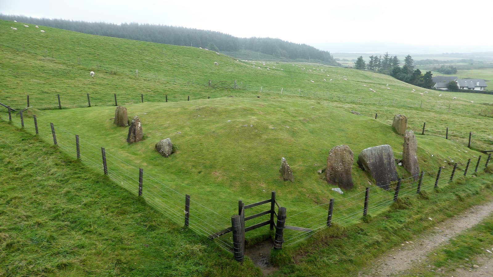
On the eastern slopes of the Isle of Arran, above the village of Whiting Bay, two Neolithic chambered cairns stand in a clearing among the trees. Known as the Giants' Graves, they are Clyde-type long cairns built between 3500 and 4000 BCE by farming communities who chose this ridge, 120 metres above the sea, as the place to house their dead. The northern cairn stretches 35 metres long, with a chambered interior once entered through a concave forecourt designed for gathering and ceremony. To the south, a smaller cairn lies at right angles, as though the builders intended two monuments to hold this clearing between them. From the ridge, views open across Whiting Bay to Holy Island, a place that has drawn seekers of solitude for millennia. The cairns have watched that island for over five thousand years.
The walk begins at Ashdale Bridge in Whiting Bay and follows a forest trail uphill through broadleaf and conifer woodland. The path narrows. The sound of the sea fades. After climbing steadily, you arrive at a clearing where the trees pull back to reveal two long cairns set on a ridge overlooking the water far below. This is the Giants' Graves. The name belongs to a later age, when Gaelic tradition attributed these ancient structures to the legendary giant Fin-Ma-Coul, the Scots-Gaelic form of Fionn mac Cumhaill. But the cairns predate those stories by thousands of years. They were built by Neolithic farming communities sometime around 3500 to 4000 BCE, making them among the earliest monumental tombs in Scotland. The builders chose the Clyde-type design: a long trapezoidal cairn with a chambered interior accessible through a passage at one end, fronted by a concave forecourt that created a natural arena for ceremony. The northern cairn is the larger, approximately 35 metres long and 20 metres wide, tapering from a broad facade at its north end. The burial chamber runs 6.7 metres long, narrowing from 1.5 metres to less than a metre wide. Within it, excavators in 1902 found fragments of cremated bone, pottery sherds, flint knives, and leaf-shaped arrowheads. These were not isolated deposits but accumulated offerings, placed over generations as the community returned to their dead. The southern cairn sits about 18 metres away at right angles, smaller and more compact at 13 metres long. Its chamber, excavated more fully in 1961-62, yielded nine sherds of a round-based vessel and further burnt bone. Two cairns, two orientations, two ways of addressing the same landscape. Together they hold the clearing. They are part of something larger. Arran contains over twenty-eight chambered cairns, one of the densest concentrations in Scotland. This island, visible from the Ayrshire coast and Kintyre, may have served as a communal ceremonial landscape for communities across the wider Firth of Clyde. People came here to bury their dead, to build monuments that would endure, to perform the rites that bound the living to those who had gone before them. The Giants' Graves are two nodes in that ancient web of obligation and remembrance.
Context and lineage
Sometime around 3500 to 4000 BCE, Neolithic farming communities on the Isle of Arran chose a ridge above Whiting Bay to build two chambered cairns. They were not the first to build on Arran; the island already held a growing collection of such monuments, eventually numbering over twenty-eight. But these builders chose their site with particular care. The ridge commanded views across the bay to the open sea and to the long profile of what is now Holy Island. They built in the Clyde style, raising trapezoidal mounds of stone with chambered interiors accessible through passages. The northern cairn was the larger, its facade shaped into a concave forecourt with horn-like projections, creating a natural amphitheatre where the community could gather for ceremony. Inside, the chamber narrowed from 1.5 metres to less than a metre, its walls closing in around whoever entered. Here they placed their dead, cremated remains accompanied by pottery vessels, flint knives, and leaf-shaped arrowheads. The objects speak of a community that equipped its dead for whatever came next. These were not single burials sealed forever but communal deposits built up over generations. The community returned to these chambers, opened them, placed new dead alongside old, and sealed them again. Each return was an act of continuity, a reaffirmation that the dead and the living belonged to the same community. The smaller southern cairn, built at right angles 18 metres away, served the same purpose on a more intimate scale. Its chamber held burnt bone and the sherds of a round-based vessel. Centuries passed. The cairns were used into the Bronze Age, if the beaker pottery fragments found in the northern chamber are any guide. Eventually, the visits ceased. Vegetation grew over the stones. Gaelic-speaking communities, arriving millennia later, looked at these grassy mounds and attributed them to giants. The giant Fin-Ma-Coul, known elsewhere as Fionn mac Cumhaill, was said to rest here. The name 'Giants' Graves' preserves that explanation. In 1902, archaeologist T. H. Bryce excavated both cairns, recovering the artefacts that revealed their true age and purpose. In 1961-62, A. S. Henshall returned to the southern cairn for further investigation. The site was scheduled as an ancient monument in 1953.
The Giants' Graves belong to the Clyde-type chambered cairn tradition, one of the earliest monumental tomb forms in the British Isles. The Clyde cairns are concentrated in southwest Scotland and are thought to represent a building tradition that spread from Scotland to Ireland rather than the reverse. Arran's twenty-eight chambered cairns form one of the densest concentrations in Scotland, and the island may have functioned as a communal ceremonial landscape for communities across the wider Firth of Clyde region. Other notable Neolithic sites on Arran include the Machrie Moor Stone Circles, Torrylin Cairn, and the recently discovered Drumadoon Cursus monument.
T. H. Bryce
Audrey Shore Henshall
Why this place is sacred
The thinness of the Giants' Graves operates through approach and arrival. The walk uphill through the forest is a passage from the ordinary world of the coastal village into something older and quieter. The trees close around you. The light changes. Then the clearing opens, and the cairns are there, low and long, covered in grass and bracken but unmistakably deliberate. They are not ruins. They are still doing what they were built to do: holding a space where the dead rest above the sea. The Neolithic builders who placed these cairns chose their position with care. The ridge stands 120 metres above the water, high enough to command views across Whiting Bay to Holy Island and the Scottish mainland beyond. From here, the living could look out over the world they inhabited, and the dead could look out over the world they had left. The forecourt of the northern cairn, with its concave facade and horn-like projections, created a threshold between these two conditions. Here the community gathered. Here they performed whatever rites accompanied the placing of the dead within the chamber. The forecourt was the place where the boundary was crossed.
The Giants' Graves were constructed as communal burial monuments during the Neolithic period, approximately 3500 to 4000 BCE. The Clyde-type design, with its accessible chamber and ceremonial forecourt, indicates the monuments were not sealed tombs but places where the living maintained an ongoing relationship with the dead. Remains were placed inside the chambers over generations, and the forecourt provided a ritual arena for ceremonies that accompanied each new deposit.
The cairns fell out of active use during or after the Bronze Age, though the presence of beaker pottery suggests continued engagement into the second millennium BCE. Over the centuries, vegetation covered the structures and Gaelic-speaking communities reinterpreted them as the graves of the legendary giant Fin-Ma-Coul. The name 'Giants' Graves' endures from this tradition. T. H. Bryce excavated both cairns in 1902, and A. S. Henshall returned to the southern cairn in 1961-62. The site was scheduled as an ancient monument in 1953. Today it is reached via the popular Glenashdale Falls walking circuit.
Traditions and practice
The Neolithic communities who built the Giants' Graves practised communal burial, placing cremated remains and grave goods in the stone chambers over generations. The concave forecourt of the northern cairn indicates ceremonial gatherings accompanied each deposit. The rituals themselves are unknown, but the architecture shaped them: the forecourt gathered the community, the passage drew individuals inward, the chamber received the dead.
Today the Giants' Graves are visited primarily as part of the Glenashdale Falls walking circuit. The combination of waterfall, forest, and ancient cairn creates a natural progression through layers of landscape and time. Some visitors come specifically for the cairns and spend time in contemplation at the clearing. The site's relative quietness compared to more famous Scottish monuments allows for unhurried engagement.
Follow the circular trail from Ashdale Bridge, visiting Glenashdale Falls before ascending to the cairns. The walk itself serves as preparation, each stage taking you further from the village and deeper into the landscape. At the clearing, take time with each cairn. Stand at the northern cairn's forecourt and consider the ceremonial space. Then cross to the southern cairn and look east toward Holy Island. Let the views, the silence, and the age of the place work on you at their own pace.
Neolithic communal burial
HistoricalThe Giants' Graves served as communal tombs for Neolithic farming communities, with chambers entered and re-entered over generations.
Cremation burial with grave goods. Forecourt ceremonies at the northern cairn. Repeated deposition over centuries.
Gaelic folklore of Fin-Ma-Coul
HistoricalGaelic-speaking communities attributed the cairns to the legendary giant Fionn mac Cumhaill, preserving recognition of the monuments' significance through mythology.
Oral storytelling. Naming traditions that persist in the site's identity today.
Contemporary contemplative walking
ActiveThe Glenashdale Falls and Giants' Graves circular walk has become a popular route that combines natural beauty with encounter with deep antiquity.
Walking the forest trail. Contemplation at the clearing. Viewing the landscape from the ridge.
Experience and perspectives
The Isle of Arran is reached by ferry from Ardrossan to Brodick, a crossing of about fifty-five minutes across the Firth of Clyde. From Brodick, the road south follows the coast through Lamlash, with its views of Holy Island, and on to Whiting Bay. The walk begins at Ashdale Bridge at the southern end of the village, where a signed path leads into the glen. The trail follows the Glenashdale Burn upstream through broadleaf and conifer woodland. After about five hundred metres, a path forks left and climbs steeply to the cairns. Alternatively, the circular route continues to Glenashdale Falls first, where a double cascade drops through a narrow gorge, and then loops back through the forest to approach the cairns from above. Either way, you arrive at a clearing on the ridge. The northern cairn occupies the main space, its trapezoidal outline still visible despite centuries of turf and bracken growth. Walk to the northern end, where the concave forecourt once provided a stage for ceremony. The standing stones that formed the facade are partly visible, including a large upright at the northeast corner. The horn-like projections of the forecourt create a sense of enclosure, gathering you in as they gathered the Neolithic community. The chamber entrance lies between the facade stones. Do not enter; instead, stand at the threshold and consider what it meant to bring the dead here, to climb this ridge bearing bones and offerings, to place them in the stone chamber and seal the entrance knowing the community would return. Twenty metres to the south, the smaller cairn lies at right angles, oriented east-west. Its single chamber held its own dead. Between the two cairns, the clearing opens to views across Whiting Bay. Holy Island lies directly in the sightline, its long ridge visible against the eastern horizon. Whatever meaning the Neolithic builders ascribed to that island, it was part of their view from this place of the dead. It remains part of yours.
The Giants' Graves stand on a wooded ridge approximately 120 metres above sea level, above the village of Whiting Bay on the eastern coast of the Isle of Arran. The northern cairn is oriented roughly north-south with its forecourt at the north end. The southern cairn lies approximately 18 metres to the south at right angles, on a west-northwest to east-southeast axis. Views extend east across Whiting Bay to Holy Island and the Scottish mainland.
The Giants' Graves invite consideration through archaeology, folklore, and the direct experience of walking through forest to encounter monuments that have occupied this ridge for over five thousand years.
Archaeologists classify the Giants' Graves as Clyde-type chambered long cairns, among the earliest monumental tomb types in Britain, dating to approximately 3500-4000 BCE. T. H. Bryce's 1902 excavation and Henshall's 1961-62 investigation revealed communal burial practices involving cremation, with grave goods including pottery, flint knives, and arrowheads. The northern cairn's concave forecourt with horned projections is interpreted as a ritual arena for funerary ceremonies. Arran's twenty-eight chambered cairns represent one of Scotland's densest concentrations, and recent LiDAR survey work has revealed approximately a thousand previously unknown archaeological sites on the island, including the Drumadoon Cursus, the most complete Neolithic cursus monument in Britain.
Gaelic tradition renamed the cairns as the graves of Fin-Ma-Coul, the Scots-Gaelic form of Fionn mac Cumhaill, the legendary hero-giant of Irish and Scottish mythology. The name of Arran itself was sometimes etymologised from 'Arjn' or 'Arfyn,' meaning 'the place of the giant Fin-Ma-Couls slaughter.' This tradition reflects a widespread pattern in which communities explained monumental prehistoric remains through heroic mythology, honouring the scale of the monuments by attributing them to beings of comparable stature.
Some visitors approaching the cairns through the lens of sacred landscape studies note the deliberate siting above the sea with views to Holy Island, interpreting this as evidence of a cosmological awareness in which the placement of the dead was connected to the wider landscape of sea, island, and horizon. The concentration of ancient monuments on Arran has drawn interest from those exploring the concept of islands as sacred centres.
Whether the two cairns served the same community or different groups remains uncertain. The precise rituals performed in the forecourt areas are lost. Why Arran attracted such an extraordinary concentration of chambered cairns is not fully understood. The relationship between the cairn builders and the earlier or contemporary communities who erected the Machrie Moor stone circles is still being investigated.
Visit planning
Whiting Bay has guest houses, holiday cottages, and a campsite. More accommodation options in Brodick and Lamlash. Book in advance during summer months.
These are burial monuments over five thousand years old. They contain human remains. Treat them accordingly.
Dress for Scottish outdoor conditions. Waterproofs and sturdy walking boots are essential. The trail is approximately 5 kilometres round trip with moderate elevation gain.
Photography is permitted. The clearing offers varied light through the canopy, and the views toward Holy Island provide a natural backdrop.
Not traditionally associated with offerings. Presence and attentiveness are sufficient.
Do not disturb the scheduled monument. Do not enter the chambers. Do not remove stones or artefacts. No metal detecting.
Plan your visit
Address
National Cycle Route 8, Isle of Arran KA27 8QP, UK
Hours
Hours, fees, and access can change — verify on the official source before you travel. Practical details last checked Jun 2026.
Nearby sacred places
Sacred places within a half-day’s reach. Pilgrims often visit them together: walk one, stay for the other.


References
Sources consulted when researching this page. Independent verification by readers is welcome.
- 01Arran, Whiting Bay, Giant's Graves North - Canmore — Historic Environment Scotland / Canmorehigh-reliability
- 02Arran, Whiting Bay, Giant's Graves South - Canmore — Historic Environment Scotland / Canmorehigh-reliability
- 03Giants' Graves, long cairns, Whiting Bay, Arran (SM398) — Historic Environment Scotlandhigh-reliability
- 04Giants' Graves, Arran - Wikipedia — Wikipedia contributors
- 05Giants' Graves - The Modern Antiquarian — The Modern Antiquarian
- 06Glenashdale Falls & Giant's Graves, Whiting Bay - WalkHighlands — WalkHighlands
- 07Giants' Graves, long cairns, Whiting Bay, Arran - Ancient Monuments UK — Ancient Monuments UK
- 08Neolithic Arran: an essay - The Urban Prehistorian — The Urban Prehistorian
- 09Giants' Graves, Arran - Britain Express — Britain Express
- 10Giants' Graves - Ayrshire and Arran — Ayrshire and Arran tourism
Key questions
What pilgrims usually ask
- Why is Giants' Graves considered sacred?
- Visit the Giants' Graves on Arran, two 5,000-year-old Neolithic chambered cairns on a forest ridge above Whiting Bay with views to Holy Island.
- What should I wear at Giants' Graves?
- Dress for Scottish outdoor conditions. Waterproofs and sturdy walking boots are essential. The trail is approximately 5 kilometres round trip with moderate elevation gain.
- Can I take photos at Giants' Graves?
- Photography is permitted. The clearing offers varied light through the canopy, and the views toward Holy Island provide a natural backdrop.
- How long should I spend at Giants' Graves?
- 2-3 hours to include contemplative time at the cairns
- What offerings are appropriate at Giants' Graves?
- Not traditionally associated with offerings. Presence and attentiveness are sufficient.
- What etiquette should visitors follow at Giants' Graves?
- These are burial monuments over five thousand years old. They contain human remains. Treat them accordingly.
- What is the history of Giants' Graves?
- Sometime around 3500 to 4000 BCE, Neolithic farming communities on the Isle of Arran chose a ridge above Whiting Bay to build two chambered cairns. They were not the first to build on Arran; the island already held a growing collection of such monuments, eventually numbering over twenty-eight. But these builders chose their site with particular care. The ridge commanded views across the bay to the open sea and to the long profile of what is now Holy Island. They built in the Clyde style, raising trapezoidal mounds of stone with chambered interiors accessible through passages. The northern cairn was the larger, its facade shaped into a concave forecourt with horn-like projections, creating a natural amphitheatre where the community could gather for ceremony. Inside, the chamber narrowed from 1.5 metres to less than a metre, its walls closing in around whoever entered. Here they placed their dead, cremated remains accompanied by pottery vessels, flint knives, and leaf-shaped arrowheads. The objects speak of a community that equipped its dead for whatever came next. These were not single burials sealed forever but communal deposits built up over generations. The community returned to these chambers, opened them, placed new dead alongside old, and sealed them again. Each return was an act of continuity, a reaffirmation that the dead and the living belonged to the same community. The smaller southern cairn, built at right angles 18 metres away, served the same purpose on a more intimate scale. Its chamber held burnt bone and the sherds of a round-based vessel. Centuries passed. The cairns were used into the Bronze Age, if the beaker pottery fragments found in the northern chamber are any guide. Eventually, the visits ceased. Vegetation grew over the stones. Gaelic-speaking communities, arriving millennia later, looked at these grassy mounds and attributed them to giants. The giant Fin-Ma-Coul, known elsewhere as Fionn mac Cumhaill, was said to rest here. The name 'Giants' Graves' preserves that explanation. In 1902, archaeologist T. H. Bryce excavated both cairns, recovering the artefacts that revealed their true age and purpose. In 1961-62, A. S. Henshall returned to the southern cairn for further investigation. The site was scheduled as an ancient monument in 1953.
- Who is associated with Giants' Graves?
- T. H. Bryce, Audrey Shore Henshall