Auchagallon Curved Cairn
A Bronze Age burial cairn above Machrie Bay, where fifteen red and grey stones hold watch over the western sea
Machrie, North Ayrshire, United Kingdom
Plan this visit
Practical context before you go
45-60 minutes to fully experience the site and the views
Free access. Respect the monument as a burial site. Use the lane rather than crossing fields. Leave nothing behind.
At a glance
- Coordinates
- 55.5598, -5.3428
- Type
- Cairn
- Suggested duration
- 45-60 minutes to fully experience the site and the views
Pilgrim tips
- Sturdy footwear for the uphill walk. Waterproofs advisable in Scottish island weather.
- Freely permitted. Late afternoon light on the red sandstone is particularly rewarding.
- The hillside can be wet and slippery in rain. Arran weather changes quickly. The site is exposed to wind from the west.
Overview
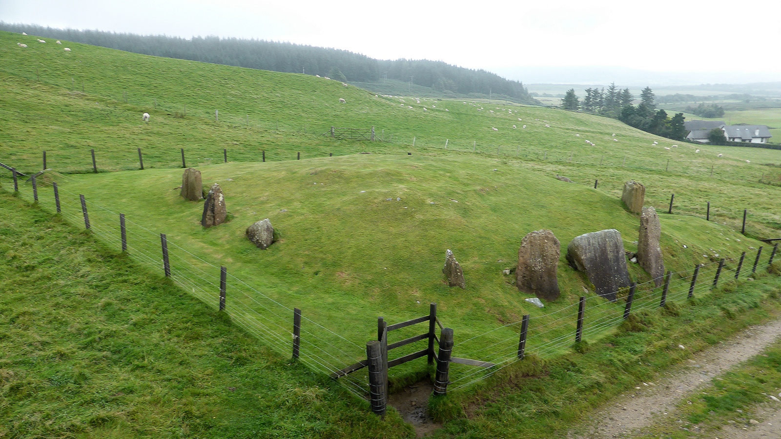
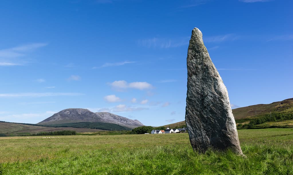
On the west coast of the Isle of Arran, on a shelf of hillside above Machrie Bay, fifteen upright stones form a circle around the remains of a Bronze Age burial cairn. Most are red sandstone. Two are grey granite. No one knows why the builders chose to mix the materials. The stones are graded in height, the tallest on the downhill side facing the sea, the shortest on the uphill side, as though the monument was designed to present a uniform profile when seen from the bay below. Inside, a cist was found in the 19th century. What it contained, beyond a stone box in the earth, is lost to poor record-keeping. Auchagallon has never been properly excavated. It remains an enigma on a hillside, looking west across the Kilbrannan Sound toward Kintyre.
The path up from the road is short and steep enough to change your breathing. Within five minutes you leave the tarmac world behind and arrive on a shelf of land that someone chose four thousand years ago as a fitting place to honour the dead. The fifteen stones of Auchagallon stand in a rough circle, 14.5 metres across, surrounding what was once a cairn of heaped stones covering a burial. The cairn has largely gone, eroded or removed over centuries, but the kerb stones remain, planted deep in the earth, each one placed with care. Thirteen of the stones are red sandstone, the dominant rock of western Arran. Two are grey granite. The contrast is visible immediately: warm red-brown against cool grey-white. Whether this distinction carried meaning for the builders or simply reflected what was available, no one can say. But when you stand among them, the eye is drawn to the granite stones as though they mark something different, something set apart. The grading of the stones is deliberate. On the western, downhill side, where the land falls away toward Machrie Bay, the stones are tallest, reaching up to 2.3 metres. On the eastern, uphill side, they shrink to half a metre. The effect from below would have been a monument of even height, its profile level against the sky. The effect from within is different: standing at the centre, you are enclosed by stone on the uphill side and opened to the sea on the downhill side. The bay spreads below. The Kilbrannan Sound stretches toward Kintyre. The sky, on Arran, is rarely still. Just to the south lies Machrie Moor, where six stone circles mark what was once one of Scotland's most significant prehistoric ceremonial landscapes. Auchagallon belongs to this broader world of ritual and remembrance, though it stands apart from the moor, elevated, looking outward rather than inward. The cairn builders chose a place where the dead could face the setting sun and the open water. Whatever else has been forgotten, that choice remains legible.
Context and lineage
Around 2000 BC, a community on the western coast of the Isle of Arran selected a shelf of hillside above Machrie Bay as the burial place for a person of significance. They dug a cist, a box of stone slabs, into the earth, placed the body inside with whatever grave goods custom demanded, and sealed it. Over the cist they heaped a cairn of stones. Around the cairn they set fifteen upright slabs as a kerb, grading the heights so that the tallest stones faced the sea and the shortest faced the hill. Thirteen stones were red sandstone, the local rock. Two were grey granite, sourced separately, deliberately different. The result was a monument visible from the bay below, its profile even against the sky, marking the place where the dead rested above the living world. The cairn stood for centuries, then millennia. The heaped stones were eventually lost. The kerb stones endured. In the 19th century, diggers opened the centre and found the cist. What else they found, they did not record. The monument passed into state care. It stands now as it has stood for four thousand years: fifteen stones on a hillside, looking west.
Auchagallon belongs to the tradition of kerbed cairns found across western Scotland and Ireland during the Early Bronze Age. It is part of the broader prehistoric landscape of western Arran, which includes the Machrie Moor stone circles (six circles dating from Neolithic to Bronze Age), Tormore, and other ceremonial and funerary sites. This concentration of monuments indicates that the western coast of Arran was a significant ritual landscape for at least two thousand years.
Unknown 19th-century antiquarians
Why this place is sacred
Auchagallon holds something that more thoroughly investigated sites have surrendered: the unknown. Victorian antiquarians dug into the centre and found a cist, a stone box designed to hold a burial. But what the cist contained, whether bones remained, what grave goods accompanied the dead, whether the body lay crouched as was customary, none of this was recorded. The excavators took what they found and left no account. This incompleteness is not a failing of the monument but a condition of its power. You stand among the stones knowing that someone lies beneath your feet, honoured four thousand years ago with an elaborate cairn and a ring of graded stones, and you cannot know who they were. The site resists the closure that knowledge brings. The setting amplifies this quality. The west-facing hillside receives the afternoon and evening light directly, warming the red sandstone to the colour of old terracotta. The two grey granite stones catch the light differently, cooler, more reflective. As the sun moves westward over the sea, the monument shifts through registers of colour and shadow that the builders may have intended or may simply have received as a gift of the stone they chose. The view is expansive. Machrie Bay lies below, its curve of sand and farmland reaching toward the sea. The Kilbrannan Sound separates Arran from the long spine of Kintyre. On clear days the coast opposite is visible; on others, the sea and sky merge into a single grey expanse. This is a place positioned between the known and the unknown, the land and the sea, the living and the dead.
Auchagallon was built as a kerbed burial cairn approximately 2000 BC. The body of a person of importance was placed in a cist, a stone-lined burial chamber, beneath the ground. Prestigious objects were likely placed beside the body. The cairn was then heaped over the cist and edged with a kerb of graded upright stones. The monument served as a visible marker in the landscape, honouring the dead and asserting the presence of the living community.
The cairn was built in the Early Bronze Age. At some unknown point, the cairn material above the cist was lost to erosion or removal, leaving the kerb stones standing as an apparent stone circle. In the 19th century, unnamed antiquarians excavated the centre and found the cist, but left no proper records. The site was taken into state care and is now managed by Historic Environment Scotland as a scheduled ancient monument. No modern archaeological excavation has been conducted.
Traditions and practice
The cairn was a funerary monument. The dead were placed in a cist beneath the cairn with grave goods. The construction of the kerb, with its graded heights and contrasting stone types, may have been a ritualised act in itself. The relationship to Machrie Moor below suggests the cairn was part of a wider system of ritual movement through the landscape.
Visitors walk to the site for quiet contemplation and to experience the prehistoric landscape of western Arran. Some combine a visit with Machrie Moor stone circles as part of a walking route through the ancient sites. Photography, particularly in the late afternoon light, is common.
Approach on foot from the signposted lane. Let the short uphill walk transition you from the road to the monument. Walk around the outside of the circle first, observing the graded heights and the two grey granite stones. Then enter and stand at the centre. Face west, toward the sea. Consider that the person buried here was placed to face this same view four thousand years ago. If time allows, walk south to Machrie Moor to connect the elevated burial site with the ceremonial landscape on the moor below.
Bronze Age kerbed cairn burial tradition
HistoricalThe cairn was built approximately 2000 BC as an elaborate burial monument. The kerbed construction, graded stone heights, and use of contrasting stone materials indicate a ritual tradition with specific conventions about how the dead should be honoured and the living landscape marked.
Cist burial beneath a cairn of heaped stones, edged with a kerb of upright slabs. Probable deposition of pottery and flint tools as grave goods. Deliberate selection of site on elevated ground facing the western sea.
Contemporary contemplative visiting
ActiveModern visitors drawn to Arran's prehistoric landscape include Auchagallon as a quieter, more intimate alternative to Machrie Moor.
Walking to the site, standing among the stones, contemplating the views and the unknown burial beneath. Photography. Combining the visit with walks to other prehistoric sites on the western coast.
Experience and perspectives
You will likely be alone. Auchagallon does not appear in most guidebooks, and even visitors who come to Arran for its prehistoric sites often head straight to Machrie Moor without stopping here. This is the site's gift. The approach is signposted from the A841 coast road, at the junction near Machrie golf course, about four miles north of Blackwaterfoot. A short lane leads uphill. There is space to park at the roadside, and a sign asks visitors to walk up the lane rather than crossing the fields. The walk takes five minutes and carries you from the level coast to an elevated shelf where the light and the air change. You are higher now, and the bay opens below. The stones appear as you crest the slope. They are not dramatic in the manner of tall standing stones; the tallest reaches 2.3 metres, and many are shorter. Their power lies in their arrangement, their colours, and their setting. Walk around the outside first, noting how the heights change, tallest facing the sea, shortest facing the hill. Then enter the circle and stand at the centre where the cist was found. Look west. The builders placed this monument so the dead would face the open water and the setting sun. The evening light is particularly fine here. If you visit in late afternoon, the red sandstone glows and the shadows lengthen eastward up the hill. The two grey granite stones stand out like sentinels of a different order. From this vantage you can also see southward toward Machrie Moor, where the stone circles stand on the level ground below. Auchagallon and Machrie Moor together represent a landscape of ritual activity spanning centuries, perhaps millennia. Walking between them, along the coast road or across the hillside, connects the elevated burial site to the ceremonial arena on the moor.
Auchagallon stands on a west-facing hillside above Machrie Bay on the Isle of Arran. The stones form a circle approximately 14.5 metres in diameter. The tallest stones are on the western (downhill) side, the shortest on the eastern (uphill) side. The centre of the circle, where the cist was found, is the focal point. Machrie Moor stone circles lie approximately 1.5 miles to the south.
Auchagallon invites interpretation through archaeology, landscape, and the quality of not-knowing that an unexcavated site preserves.
Archaeologists now classify Auchagallon as a kerbed cairn rather than a true stone circle. The fifteen upright stones formed the kerb of a burial cairn, with a cist found at the centre during 19th-century excavation. The graded stone heights may have served to present a uniform profile when viewed from below, or may reflect ritual significance. The two grey granite stones among the red sandstone majority remain unexplained. The site dates to the Early Bronze Age, approximately 2000 BC. No modern excavation has been conducted, leaving many questions unanswered.
No specific folk traditions are recorded for Auchagallon. The broader Arran landscape carries Gaelic place names and associations with Finn MacCool (Fionn mac Cumhaill), the mythical giant warrior of Gaelic tradition, particularly at nearby Machrie Moor where the stone circles are sometimes called 'Fingal's Cauldron Seat.' The Isle of Arran sits in the Firth of Clyde, a crossing point between the Gaelic west and the Lowland east, and its monuments belong to both worlds.
The cairn's west-facing position overlooking the sea has drawn interpretations connecting it to beliefs about the dead journeying westward. In many Atlantic cultures, the west, where the sun sets over the ocean, was associated with the otherworld or the land of the dead. Auchagallon's orientation may reflect this cosmology, placing the deceased to face their destination.
Almost everything about Auchagallon remains uncertain. The 19th-century excavation produced no proper records. Whether the cist contained a single burial or multiple remains, what grave goods accompanied the dead, whether the cairn had a passage or entrance, and whether the graded stones and mixed materials held specific symbolic meaning are all unknown. The site has never been excavated using modern methods. This is simultaneously a gap in knowledge and a preservation of mystery.
Visit planning
Accommodation available in Blackwaterfoot (4 miles), Machrie, and Brodick. The island has a range of B&Bs, hotels, and self-catering options. Book in advance for summer.
Free access. Respect the monument as a burial site. Use the lane rather than crossing fields. Leave nothing behind.
Sturdy footwear for the uphill walk. Waterproofs advisable in Scottish island weather.
Freely permitted. Late afternoon light on the red sandstone is particularly rewarding.
Do not leave offerings or disturb the scheduled monument.
Scheduled ancient monument. No disturbance, no metal detecting, no removal of material.
Plan your visit
Address
Auchangallon Jetty, Isle of Arran KA27 8DZ, UK
Hours
Hours, fees, and access can change — verify on the official source before you travel. Practical details last checked Jun 2026.
Nearby sacred places
Sacred places within a half-day’s reach. Pilgrims often visit them together: walk one, stay for the other.


References
Sources consulted when researching this page. Independent verification by readers is welcome.
- 01Auchagallon Cairn - Historic Environment Scotland — Historic Environment Scotlandhigh-reliability
- 02Auchagallon Cairn: History - Historic Environment Scotland — Historic Environment Scotlandhigh-reliability
- 03Arran, Auchengallon - Canmore — Historic Environment Scotland / Canmorehigh-reliability
- 04Auchagallon Stone Circle - Wikipedia — Wikipedia contributors
- 05Auchagallon Stone Circle - The Megalithic Portal — The Megalithic Portal
- 06The Isle of Arran: Auchagallon Cairn - Dr Aaron Watson — Dr Aaron Watson
- 07Auchagallon Stone Circle, Isle of Arran - Britain Express — Britain Express
- 08Auchagallon Stone Circle - Undiscovered Scotland — Undiscovered Scotland
- 09Saints and Stones: Auchagallon Kerbed Cairn — Saints and Stones
- 10Auchagallon Cairn - Scotland Off the Beaten Track — Scotland Off the Beaten Track
Key questions
What pilgrims usually ask
- Why is Auchagallon Curved Cairn considered sacred?
- Visit Auchagallon kerbed cairn on the Isle of Arran, a Bronze Age burial monument of fifteen red sandstone and grey granite stones overlooking Machrie Bay.
- What should I wear at Auchagallon Curved Cairn?
- Sturdy footwear for the uphill walk. Waterproofs advisable in Scottish island weather.
- Can I take photos at Auchagallon Curved Cairn?
- Freely permitted. Late afternoon light on the red sandstone is particularly rewarding.
- How long should I spend at Auchagallon Curved Cairn?
- 45-60 minutes to fully experience the site and the views
- What offerings are appropriate at Auchagallon Curved Cairn?
- Do not leave offerings or disturb the scheduled monument.
- What etiquette should visitors follow at Auchagallon Curved Cairn?
- Free access. Respect the monument as a burial site. Use the lane rather than crossing fields. Leave nothing behind.
- What is the history of Auchagallon Curved Cairn?
- Around 2000 BC, a community on the western coast of the Isle of Arran selected a shelf of hillside above Machrie Bay as the burial place for a person of significance. They dug a cist, a box of stone slabs, into the earth, placed the body inside with whatever grave goods custom demanded, and sealed it. Over the cist they heaped a cairn of stones. Around the cairn they set fifteen upright slabs as a kerb, grading the heights so that the tallest stones faced the sea and the shortest faced the hill. Thirteen stones were red sandstone, the local rock. Two were grey granite, sourced separately, deliberately different. The result was a monument visible from the bay below, its profile even against the sky, marking the place where the dead rested above the living world. The cairn stood for centuries, then millennia. The heaped stones were eventually lost. The kerb stones endured. In the 19th century, diggers opened the centre and found the cist. What else they found, they did not record. The monument passed into state care. It stands now as it has stood for four thousand years: fifteen stones on a hillside, looking west.
- Who is associated with Auchagallon Curved Cairn?
- Unknown 19th-century antiquarians