Carrowkeel
A Neolithic necropolis older than the pyramids, aligned to the solstice sun on an Irish mountain ridge
County Sligo, Ballymote-Tubbercurry Municipal District, Ireland
Plan this visit
Practical context before you go
3 to 4 hours to explore the cairns, walk the ridgeline, and spend contemplative time at Cairn G
Treat the site as a five-thousand-year-old burial ground. Do not climb on, mark, or remove anything from the cairns. Leave no trace.
At a glance
- Coordinates
- 54.0573, -8.3791
- Type
- Megalithic site
- Suggested duration
- 3 to 4 hours to explore the cairns, walk the ridgeline, and spend contemplative time at Cairn G
Pilgrim tips
- Sturdy walking shoes or hiking boots. Breathable, layered clothing suitable for exposed mountain conditions. Waterproof outer layers advised. The site is at elevation and fully exposed to wind and weather.
- Photography is permitted and the site is highly photogenic. Be mindful of others' experiences, particularly during solstice gatherings. Drone photography may be subject to National Monument restrictions; check current regulations.
- The site is remote and fully exposed to mountain weather. Sturdy walking shoes or hiking boots are essential. Rain gear and warm layers advised even in summer. Mobile phone signal may be weak or absent on the mountain. The nearest settlement with reliable signal is Castlebaldwin. Some cairn passages are low and narrow; take care entering. Do not enter cairns that appear structurally unstable. The Bricklieve Mountains are a Special Area of Conservation; follow leave-no-trace principles.
Overview
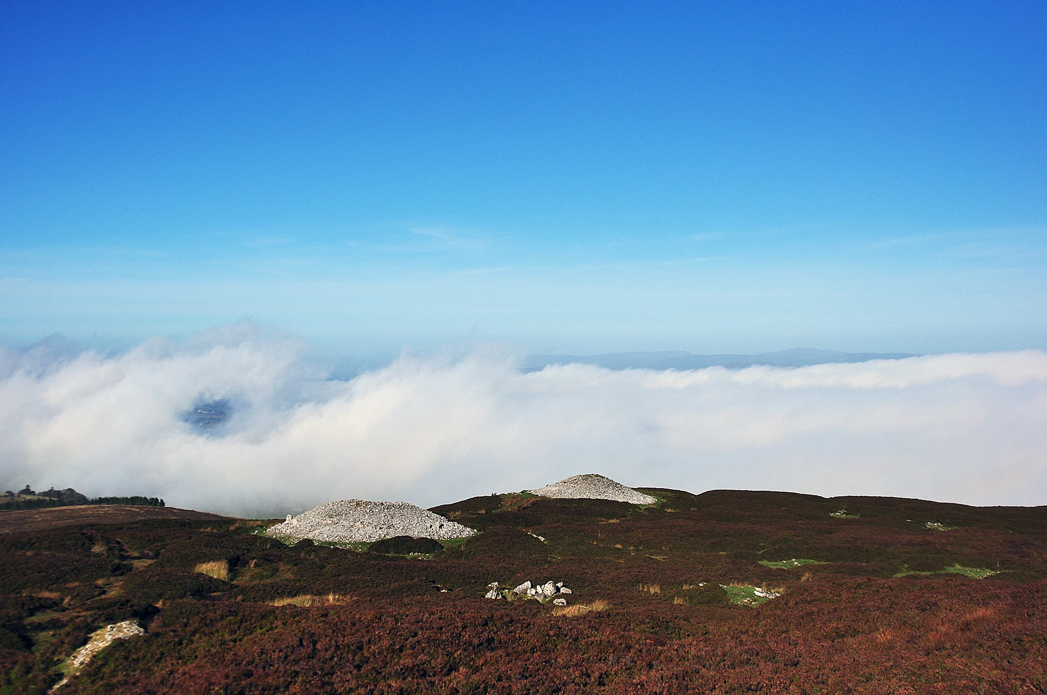
On the Bricklieve Mountains in County Sligo, fourteen cairns built over five thousand years ago crown the ridgeline like stone sentinels. Inside Cairn G, a roofbox channels the setting sun at midsummer into a darkness that has held the cremated dead since before the pyramids of Giza were conceived. The builders came from Anatolia. Their understanding of the sky was precise. The landscape around them, soaked in mythology from the Tuatha De Danann to Queen Maeve, has never stopped being sacred.
Carrowkeel occupies the high ground of the Bricklieve Mountains in south County Sligo, a Neolithic passage tomb cemetery dating to approximately 3400-3100 BC. Fourteen cairns are distributed across the limestone ridges, their stone structures visible against the skyline from the surrounding lowlands. This is one of Ireland's four great passage tomb complexes, and among the least commercialized. There is no visitor centre, no admission fee, no guided tour. A rough track leads from a small car park through bog and heather to the cairns above. The approach takes twenty to thirty minutes of uphill walking, and by the time you reach the first monuments, the modern world has fallen away.
The cairns held the cremated remains of the Neolithic dead. DNA analysis has revealed that these people had ancestral origins in Anatolia, with greater genetic affinity to Mediterranean populations than to the Danubian farming communities that spread across northern Europe. They carried their knowledge of passage tomb construction from the continent to Ireland, and at Carrowkeel they built with a sophistication that continues to yield new understanding.
Cairn G is the most celebrated monument in the complex. Its passage leads into a cruciform chamber, and above the entrance, a roofbox channels the setting sun into the tomb during the weeks around the summer solstice. This feature is at least three hundred years older than the more famous roofbox at Newgrange. When the sun reaches the right angle, light floods the inner chamber, illuminating a space that spends most of its existence in total darkness. The effect is not metaphorical. It is engineered. The builders calculated the sun's path with precision and built their tomb to receive it.
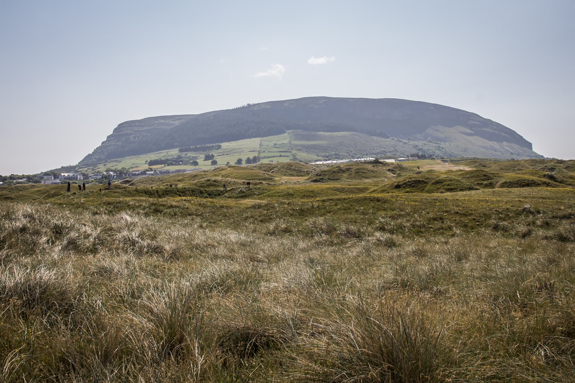
The wider landscape amplifies the significance. The Caves of Kesh Corran, visible from the cairns, are associated in Irish mythology with the Tuatha De Danann and the Otherworld. Queen Maeve's unexcavated cairn sits on Knocknarea to the northwest. Croagh Patrick, Ireland's holy mountain, is visible to the west. The alignment from Cairn K captures sunset behind Croagh Patrick on both Samhain and Imbolc, the cross-quarter days that mark the Celtic transitions between seasons. Carrowkeel does not exist in isolation. It is a node in a sacred geography that extends across the entire west of Ireland.
Context and lineage
Between approximately 3400 and 3100 BC, Neolithic farming communities built a series of passage tombs on the Bricklieve Mountain ridges above Lough Arrow in County Sligo. These communities, DNA analysis has revealed, had ancestral origins in Anatolia, with genetic profiles more closely related to Mediterranean populations than to the Danubian farming expansion of northern Europe. They brought with them the knowledge of passage tomb construction, astronomical alignment, and the funerary practices that shaped Carrowkeel.
The builders chose the high ground deliberately. The ridgeline position provides sightlines to Knocknarea, Croagh Patrick, and the Caves of Kesh Corran, integrating the cemetery into a landscape already dense with meaning. The cairns were constructed with corbelled chambers, side recesses, and passages oriented to receive sunlight at astronomically significant moments. Cairn G's roofbox, designed to channel the setting solstice sun, demonstrates a sophistication that predates the similar feature at Newgrange by at least three centuries.
In 1911, R.A.S. Macalister, R. Lloyd Praeger, and E.C.R. Armstrong conducted the first major excavation. Their methods, though pioneering for the time, included the removal of roofing stones from several cairns, causing damage that remains visible today. They documented cremated human remains, Carrowkeel Ware pottery, stone beads, and bone pins. Modern research by Thomas Kador and Lara Cassidy has added DNA analysis and refined the dating of the complex.
Carrowkeel belongs to the Irish passage tomb tradition, which includes Newgrange, Knowth, and Dowth in the Boyne Valley and the cemetery at Carrowmore in north County Sligo. The tradition has its roots in the megalithic cultures of Atlantic Europe, with connections traced through Brittany to the Iberian Peninsula and ultimately to Anatolia. Within Ireland, Carrowkeel is distinguished by the number and concentration of its cairns, the sophistication of the Cairn G roofbox, and its integration into a mythological landscape unmatched anywhere else in the country.
R.A.S. Macalister, R. Lloyd Praeger, and E.C.R. Armstrong
Martin Byrne
Anthony Murphy
The Neolithic builders
Why this place is sacred
The thinness of Carrowkeel operates through elevation, darkness, light, and time.
The elevation comes first. The Bricklieve Mountains are not high by alpine standards, but the walk up from the car park crosses a threshold that the body registers before the mind catches up. The boggy lowland gives way to heather, then to limestone pavement and exposed rock. The wind strengthens. The views open. By the time you reach the cairns, you are standing on the spine of the mountain with the landscape of County Sligo spread below in every direction. Lough Arrow gleams to the east. Knocknarea's flat-topped profile marks the northwest. On clear days, Croagh Patrick is visible to the west. You are exposed, elevated, and the cairns around you have occupied this exposure for over five thousand years.
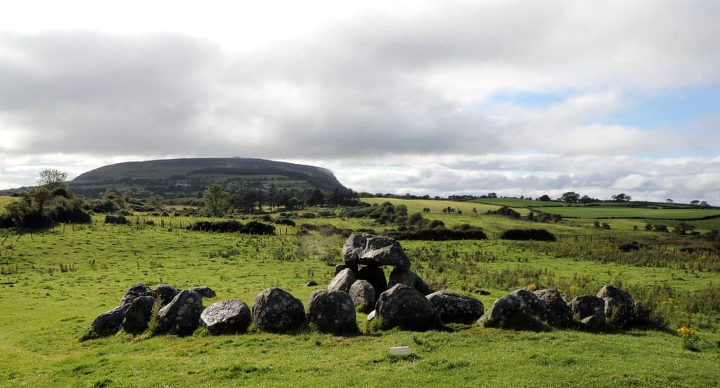
The darkness is inside the cairns. Cairn G's passage is low and narrow, requiring you to crouch or crawl. The inner chamber opens into a cruciform plan, three side chambers radiating from a central space. In the absence of sunlight, the darkness is absolute. The corbelled ceiling compresses the space. Your breathing becomes audible, then dominant. The stone that surrounds you is the same stone that held the cremated dead of a community whose faces you will never see. This is not a museum case with bones behind glass. This is the room where they were placed, and the room has not changed.
The light enters through the roofbox. Around the summer solstice, the setting sun reaches the angle at which it aligns with the roofbox above Cairn G's entrance. A beam of light penetrates the passage and floods the inner chamber, turning the darkness to gold. The contrast between the absolute dark of the chamber and the sudden illumination is total. The builders designed this moment. They calculated the sun's declination and built a stone mechanism to capture it. The roofbox at Carrowkeel is at least three hundred years older than the one at Newgrange. This is not a copy. This is where the idea matured.
The mythological density of the surrounding landscape adds a dimension that pure archaeology cannot supply. The Caves of Kesh Corran, visible from the cairns, are associated with virtually every major cycle of Irish mythology: the Tuatha De Danann, the Dagda, the Morrigan, Lugh, Fionn Mac Cumhaill, Queen Maeve, and the Cailleach. The Second Battle of Moytura, in which the divine race defeated the Fomorians, is set in the landscape around Lough Arrow. The alignment from Cairn K toward sunset behind Croagh Patrick on Samhain and Imbolc knits the cemetery into the Celtic sacred calendar. Whether the Neolithic builders would have recognized these later associations is unknowable. What is certain is that the landscape has never stopped generating sacred meaning.
The cairns served as repositories for cremated human remains and as ceremonial centres for ancestor worship, astronomical observation, and communal ritual. The astronomical alignments indicate that ceremonies were timed to solstices and cross-quarter days.
Constructed approximately 3400-3100 BC, with continued use into the Bronze Age (until approximately 1500 BC). The 1911 excavation by Macalister, Praeger, and Armstrong documented the cairns but used methods now considered destructive, including the removal of roofing stones. Modern research by Kador and Cassidy has added DNA analysis and refined dating. The site was incorporated into Irish mythology by Celtic-speaking communities who arrived millennia after the builders. Today it functions as both a National Monument and an active sacred site for modern spiritual practitioners, particularly at the summer solstice.
Traditions and practice
Neolithic practices included cremation and deposition of human remains within the passage tombs, offerings of food, drink, and precious objects, and communal gatherings likely coordinated by spiritual leaders. The characteristic Carrowkeel Ware pottery, first identified at this site, was associated with funerary rituals. The astronomical alignments indicate ceremonies timed to the summer solstice (Cairn G roofbox) and the cross-quarter days of Samhain and Imbolc (Cairn K alignment with sunset behind Croagh Patrick).
Growing numbers gather at Cairn G around the summer solstice to witness the setting sun entering the roofbox. Modern Celtic pagans and neo-druids use the site for seasonal ceremonies aligned with the Wheel of the Year, particularly at the solstice, Samhain, and Imbolc. Individual meditation and contemplation occur year-round. The site's remoteness and lack of commercial infrastructure create conditions conducive to personal reflection.
Begin by giving the walk your full attention. The uphill approach through bog and heather is not an inconvenience to be endured before reaching the cairns. It is the approach, the gradual separation from the modern world that prepares you for what is above. Walk slowly. Notice the ground changing beneath your feet. Feel the wind increasing as you gain elevation.
At the cairns, resist the impulse to rush to Cairn G. Walk the ridgeline first. Stand at the highest point and orient yourself. Find Knocknarea to the northwest, its flat summit crowned by Queen Maeve's cairn. Locate Lough Arrow to the east. On a clear day, identify Croagh Patrick to the west. You are standing in the centre of a sacred geography that extends across the entire west of Ireland.
Enter Cairn G when you are ready. The passage is low, so crouch or crawl. Inside, allow your eyes to adjust to the darkness. Turn off your phone. Sit in the central chamber and listen to the silence. This room was built for the dead, and for over five thousand years, the dead have been here. The weight of that fact needs time to register.
If you visit around the summer solstice (approximately six weeks on either side of June 21), the setting sun will enter through the roofbox. Arrive in the late afternoon and position yourself inside the chamber. The light enters slowly, a gradual brightening that transforms the darkness into gold. The builders designed this moment for their dead. You are witnessing what they intended.
Walk carefully. The terrain is uneven, some cairns are unstable, and mobile phone signal may be unreliable on the mountain.
Neolithic Passage Tomb Tradition
HistoricalThe passage tombs were built as repositories for cremated human remains and served as focal points for ancestor veneration. The builders demonstrated sophisticated understanding of astronomy, incorporating solar and lunar alignments into the tomb designs. DNA analysis has revealed ancestral origins in Anatolia.
Cremation and burial, communal gatherings, offerings of food and precious objects, ceremonies timed to solstices and cross-quarter days. Carrowkeel Ware pottery, first identified at this site, was associated with funerary rituals.
Celtic Paganism / Irish Mythology
ActiveThe Carrowkeel-Kesh Corran complex is deeply embedded in Celtic mythology. The Caves of Kesh Corran are associated with the Tuatha De Danann, and the wider landscape connects to the Dagda, the Morrigan, Lugh, Fionn Mac Cumhaill, and Queen Maeve. Cairn K aligns with sunset behind Croagh Patrick on Samhain and Imbolc.
Modern Celtic pagans gather for seasonal festivals, particularly at the summer solstice at Cairn G. Samhain and Imbolc alignments from Cairn K are observed. Meditation, ceremony, and ancestral connection at the cairns.
Archaeological Research and Conservation
ActiveOngoing archaeological research continues to reveal new findings about the builders, their origins, and their astronomical knowledge. The site is protected as a National Monument and the Bricklieve Mountains are a Special Area of Conservation.
DNA analysis, radiocarbon dating, archaeoastronomical survey, ecological conservation of the Marsh Fritillary butterfly habitat and rare orchid populations.
Experience and perspectives
The walk changes you before the cairns do. From the small car park, a track leads uphill through boggy terrain and heather. There is no paved path. The ground is uneven, sometimes wet, and the gradient is steady. Twenty to thirty minutes of walking separates you from your car, from mobile signal, from the sounds of the road. By the time the first cairns come into view on the ridgeline above, you have shed the momentum of arrival and settled into the pace of the mountain.
The cairns appear as stone mounds against the skyline, their profiles varying in size and condition. Some are tumbled, their passages collapsed. Others retain their structural integrity after five millennia. The first impression is of scale and number: these are not isolated monuments but a community of structures, spread across the ridge in a pattern that suggests deliberate placement.
Cairn G draws most visitors. Its entrance faces south-southwest, and the passage beyond is low, requiring you to stoop or crouch. Pass through the entrance and the light fades rapidly. The passage leads into a cruciform chamber, three side recesses opening from a central space. The corbelled ceiling closes over you. If you turn off any torch or phone light, the darkness is total. This is the darkness in which the Neolithic builders placed their cremated dead, wrapped in Carrowkeel Ware pottery. Sit here. Let your eyes adjust. Let the silence settle.
Above the entrance, the roofbox is visible as a narrow slit of light. Around the summer solstice, the setting sun aligns with this opening and sends a beam of light into the chamber. If you are present for this event, the experience is extraordinary: the slow brightening of the chamber as the sun descends, the beam tracking across the stone walls, the moment when the inner space is flooded with golden light. The builders intended this. They calculated it. They built a room for the dead and then arranged for the sun to visit.
Outside, walk the ridgeline between cairns. The views are panoramic and deeply significant. Knocknarea, with Queen Maeve's unexcavated cairn on its summit, dominates the northwest. The Caves of Kesh Corran are visible in the Bricklieve range below. Lough Arrow fills the eastern view. On clear days, Croagh Patrick appears to the west. The landscape reads as a map of Ireland's sacred geography, and the cairns of Carrowkeel sit at its centre.
The Bricklieve Mountains are also a Special Area of Conservation, home to the rare Marsh Fritillary butterfly and white orchids. The ecological richness of the heathland adds a living dimension to the ancient stone.
Carrowkeel is located in the Bricklieve Mountains, approximately 16 miles from Sligo town. Access is from the Boyle-Sligo road (N4) via Castlebaldwin. The car park is at the base of the mountain. The cairns are on the ridgeline above, reached by a twenty- to thirty-minute walk uphill.
Carrowkeel is understood through archaeological analysis, Irish mythology, modern spiritual practice, and the ongoing scientific investigation of its astronomical alignments. These perspectives overlap and sometimes conflict, but together they convey a site whose significance has been recognized for five millennia.
Archaeologists classify Carrowkeel as one of Ireland's four major passage tomb cemeteries, dating to approximately 3400-3100 BC. The 1911 excavation by Macalister, Praeger, and Armstrong was pioneering but used methods now considered destructive. Modern research has added DNA analysis revealing Anatolian and Mediterranean genetic origins for the builders. The roofbox at Cairn G is recognized as at least three hundred years older than the more famous example at Newgrange, demonstrating early astronomical sophistication. The cairns served both funerary and ritual purposes within a cosmologically oriented landscape. The relationship to other passage tomb complexes, particularly Carrowmore, continues to be investigated.
In Irish mythology and folk tradition, the Bricklieve Mountains and Kesh Corran are deeply embedded in the landscape of the Tuatha De Danann and the heroic cycles. The Caves of Kesh Corran are associated with enchantment and the Otherworld. The cairns are connected to ancestors and the fairy folk. The alignment with Croagh Patrick links the site to the sacred geography of western Ireland. Queen Maeve's cairn on Knocknarea, visible from the ridgeline, connects the cemetery to the sovereignty mythology of Connacht.
Modern spiritual practitioners regard Carrowkeel as one of Ireland's most potent thin places. The mountain location, astronomical alignments, and layers of mythology create conditions that practitioners describe as deeply conducive to spiritual experience. The solstice gatherings at Cairn G have grown in recent years, attracting those who work with earth energies, seasonal cycles, and ancestral connection. Some practitioners identify ley line connections between Carrowkeel, Carrowmore, and Knocknarea.
Several cairns remain unexcavated. The exact nature and full extent of the astronomical alignments across the complex are still being documented. The relationship between Carrowkeel and other passage tomb complexes in Ireland is not fully understood. The precise ritual practices of the Neolithic builders remain speculative. The DNA findings raise questions about the cultural transmission of megalithic building traditions from the Mediterranean to Ireland that have not been resolved.
Visit planning
No facilities at the site. Nearest accommodation in Castlebaldwin and Boyle (approximately 15 km south). Sligo town offers full accommodation options. Mobile phone signal may be weak or absent on the mountain; the nearest reliable signal is at Castlebaldwin. No keyholder or booking required for access.
Treat the site as a five-thousand-year-old burial ground. Do not climb on, mark, or remove anything from the cairns. Leave no trace.
Sturdy walking shoes or hiking boots. Breathable, layered clothing suitable for exposed mountain conditions. Waterproof outer layers advised. The site is at elevation and fully exposed to wind and weather.
Photography is permitted and the site is highly photogenic. Be mindful of others' experiences, particularly during solstice gatherings. Drone photography may be subject to National Monument restrictions; check current regulations.
There is no traditional offering practice. Leave no trace. Do not place objects, crystals, ribbons, or other items at or on the cairns.
Do not climb on cairn structures or disturb stones. Do not scratch or mark stones. Do not remove any material from the site. Follow leave-no-trace principles. Respect the site as both a National Monument and an ecologically sensitive conservation area. Take care entering cairns: some have low, narrow passages and potentially unstable elements.
Plan your visit
Address
Carrowkeel, Co. Sligo, Ireland
Hours
Hours, fees, and access can change — verify on the official source before you travel. Practical details last checked Jun 2026.
Nearby sacred places
Sacred places within a half-day’s reach. Pilgrims often visit them together: walk one, stay for the other.
Tobar Nalt
County Sligo, Sligo Municipal Borough District, Ireland
21.2 km away
Carrowmore
County Sligo, Sligo Municipal Borough District, Ireland
23.4 km away
Knocknarea megalthic site, Sligo, Ireland
County Sligo, Sligo Municipal Borough District, Ireland
25.8 km away

Rathcroghan
Tulsk, County Roscommon, Ireland
28.8 km away
Key questions
What pilgrims usually ask
- Why is Carrowkeel considered sacred?
- Walk to a 5,000-year-old Neolithic cemetery in the Bricklieve Mountains where the solstice sun enters an ancient roofbox older than Newgrange.
- What should I wear at Carrowkeel?
- Sturdy walking shoes or hiking boots. Breathable, layered clothing suitable for exposed mountain conditions. Waterproof outer layers advised. The site is at elevation and fully exposed to wind and weather.
- Can I take photos at Carrowkeel?
- Photography is permitted and the site is highly photogenic. Be mindful of others' experiences, particularly during solstice gatherings. Drone photography may be subject to National Monument restrictions; check current regulations.
- How long should I spend at Carrowkeel?
- 3 to 4 hours to explore the cairns, walk the ridgeline, and spend contemplative time at Cairn G
- What offerings are appropriate at Carrowkeel?
- There is no traditional offering practice. Leave no trace. Do not place objects, crystals, ribbons, or other items at or on the cairns.
- What etiquette should visitors follow at Carrowkeel?
- Treat the site as a five-thousand-year-old burial ground. Do not climb on, mark, or remove anything from the cairns. Leave no trace.
- What is the history of Carrowkeel?
- Between approximately 3400 and 3100 BC, Neolithic farming communities built a series of passage tombs on the Bricklieve Mountain ridges above Lough Arrow in County Sligo. These communities, DNA analysis has revealed, had ancestral origins in Anatolia, with genetic profiles more closely related to Mediterranean populations than to the Danubian farming expansion of northern Europe. They brought with them the knowledge of passage tomb construction, astronomical alignment, and the funerary practices that shaped Carrowkeel. The builders chose the high ground deliberately. The ridgeline position provides sightlines to Knocknarea, Croagh Patrick, and the Caves of Kesh Corran, integrating the cemetery into a landscape already dense with meaning. The cairns were constructed with corbelled chambers, side recesses, and passages oriented to receive sunlight at astronomically significant moments. Cairn G's roofbox, designed to channel the setting solstice sun, demonstrates a sophistication that predates the similar feature at Newgrange by at least three centuries. In 1911, R.A.S. Macalister, R. Lloyd Praeger, and E.C.R. Armstrong conducted the first major excavation. Their methods, though pioneering for the time, included the removal of roofing stones from several cairns, causing damage that remains visible today. They documented cremated human remains, Carrowkeel Ware pottery, stone beads, and bone pins. Modern research by Thomas Kador and Lara Cassidy has added DNA analysis and refined the dating of the complex.
- Who is associated with Carrowkeel?
- R.A.S. Macalister, R. Lloyd Praeger, and E.C.R. Armstrong, Martin Byrne, Anthony Murphy, The Neolithic builders