Callanish Stone Circle 8
A half-circle of ancient stones on a cliff edge, where the sea completes what the builders left open
Callanish, United Kingdom

Plan this visit
Practical context before you go
30-45 minutes at the site
Respect the scheduled monument. Do not climb on or damage the stones. Stay clear of the cliff edge. Leave nothing behind.
At a glance
- Coordinates
- 58.2054, -6.8293
- Type
- Stone Circle
- Suggested duration
- 30-45 minutes at the site
Pilgrim tips
- Dress for exposed Hebridean conditions. The cliff-edge position means wind can be strong and sudden. Waterproof outer layers are essential at any time of year. Sturdy footwear with good grip is necessary for the rough ground approach and the grassy, potentially slippery area around the stones. Temperatures can drop quickly, particularly when wind comes off the water.
- Photography is permitted and the setting rewards it. The stones against the backdrop of the sea strait, the bridge, and the Lewis hills offer compositions at any time of day. Dawn and dusk bring particularly striking light on the Lewisian gneiss, drawing out the mineral banding. The double-shadow effect on calm winter days is subtle but photographable with patience.
- Exercise extreme caution near the cliff edge. The drop is approximately twelve metres to the water, and there are no barriers or railings. The ground near the edge may be undercut or unstable. Keep well back from the edge, particularly in wet or windy conditions. The approach involves rough, uneven ground. This site is not suitable for those with significant mobility challenges. There are no facilities at the site.
Overview
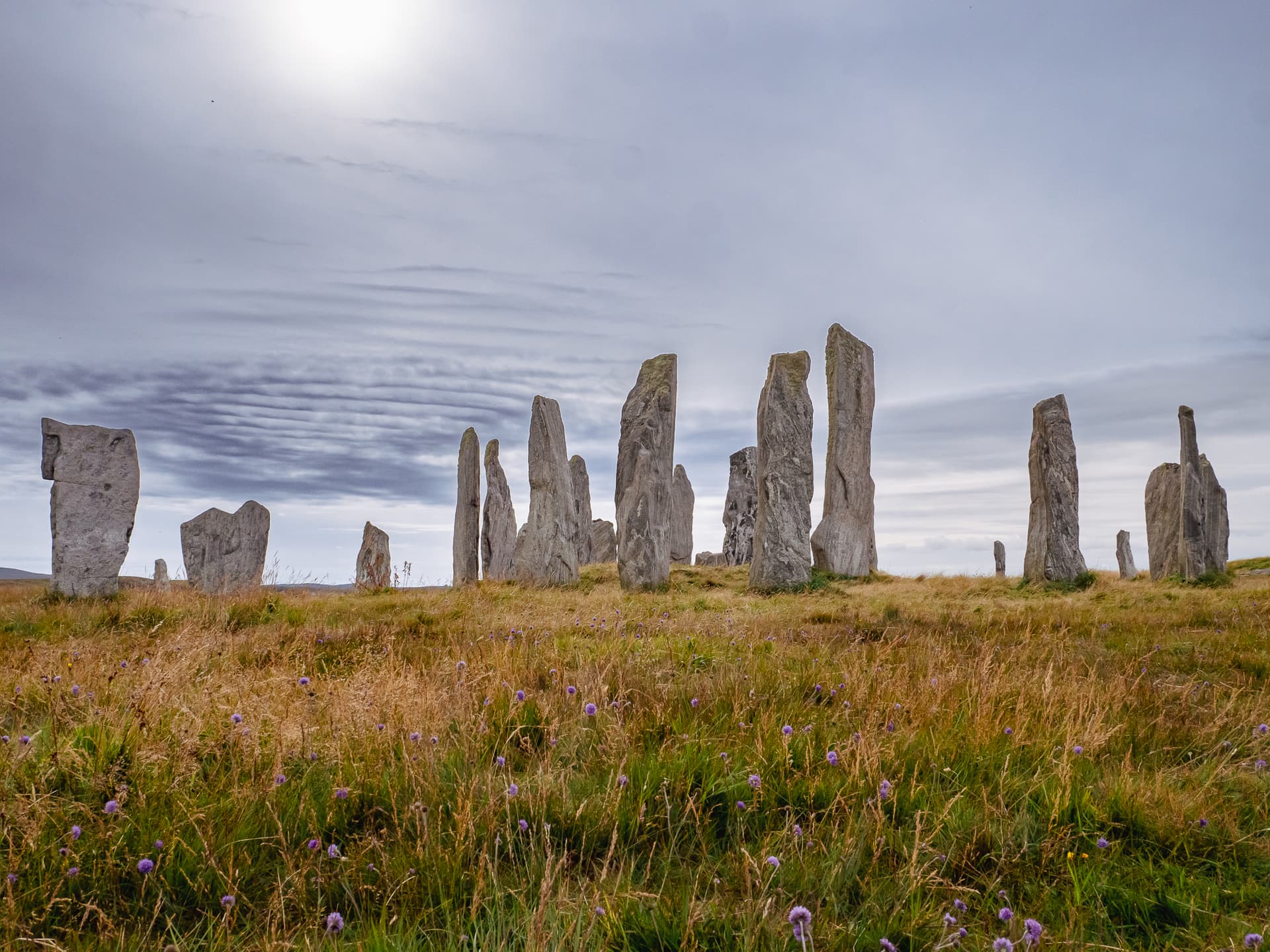
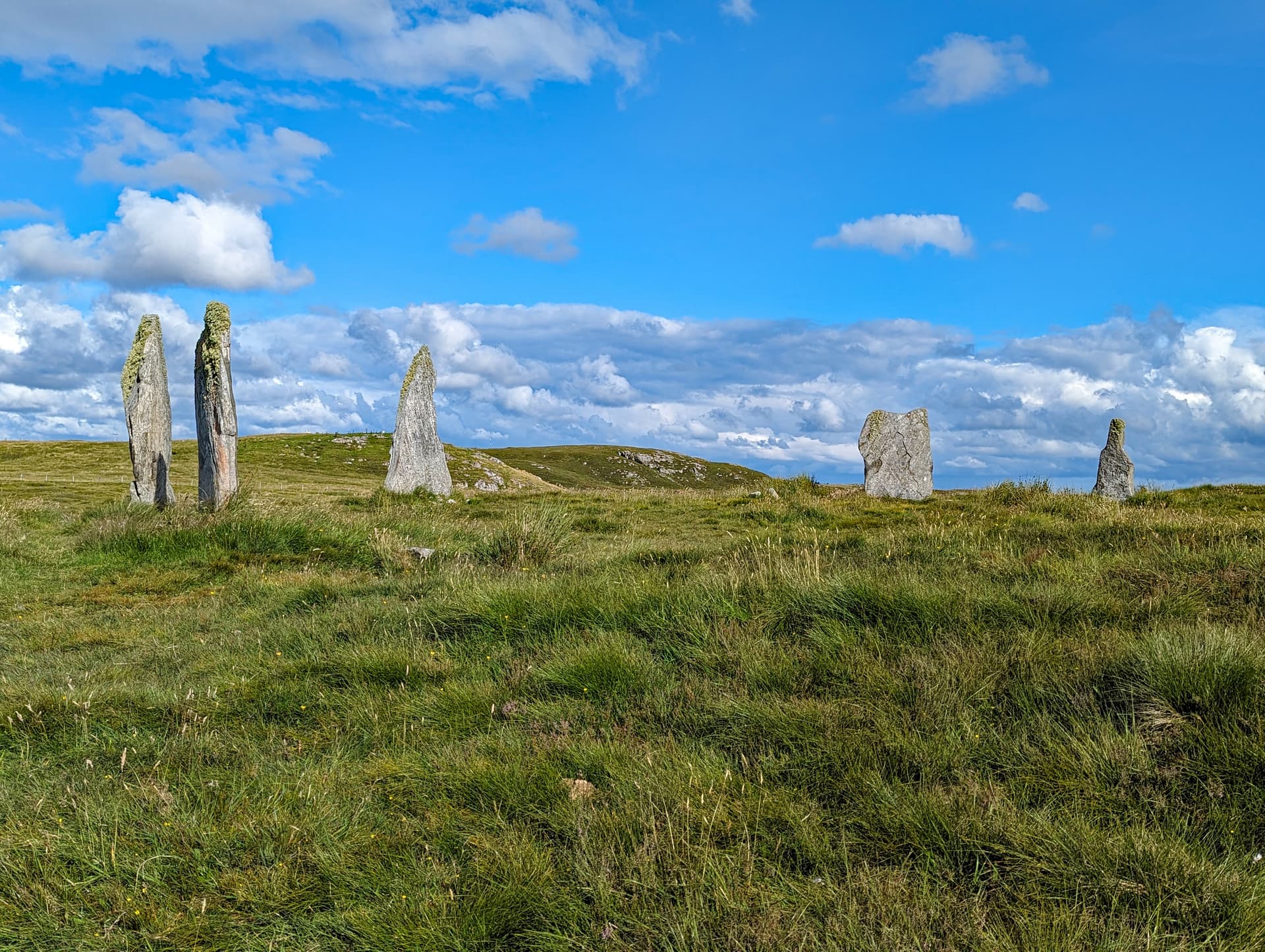
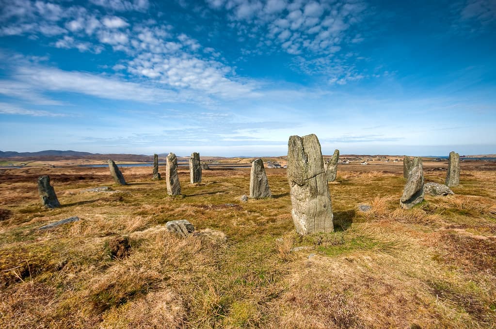
On the southern coast of Great Bernera, three standing stones and one fallen companion form a semicircle at the edge of a sheer cliff above Loch Roag. This is Callanish VIII, one of at least thirteen satellite monuments surrounding the main Callanish complex on the Isle of Lewis. The arc opens toward the water and the sky. No full circle was ever intended. The sea was always part of the design.
The stones stand where the land ends. On the southern shore of Great Bernera, just west of the bridge connecting the island to Lewis, three pillars of Lewisian gneiss rise from a cliff edge twelve metres above the water of Loch Roag. A fourth stone lies prostrate among them. Together they form a semicircle approximately twenty metres across, its open face directed toward the strait, toward Lewis, toward the horizon where the moon sets at certain intervals across its long cycle.
This is Callanish Stone Circle 8, known locally as Tursachan Cleitir. It is part of the vast Callanish ritual landscape that drew communities to this corner of the Outer Hebrides for at least fifteen hundred years, from roughly 3000 to 1500 BCE. While the great cruciform circle of Callanish I draws tens of thousands of visitors each year, this small cliff-edge monument receives only a handful. Most who come find themselves alone with the stones, the wind, and the water far below.
The semicircular form is found nowhere else in Britain. Whether the builders intended the cliff and the sea to complete the circle, or whether the half-form served a purpose entirely its own, remains one of the quiet questions the site holds. The researcher Margaret Curtis identified that the flat face of the westernmost stone aligns with moonset at the southern extreme of the lunar minor standstill, placing this small, exposed monument within a sophisticated network of astronomical observation that spans the entire Callanish landscape. The stones are Lewisian gneiss, among the oldest rock on earth at roughly three billion years. The monument built from them is perhaps five thousand years old. The gap between those numbers is itself a kind of threshold.
Context and lineage
Between roughly 3000 and 1500 BCE, the communities of the western Lewis coast constructed one of the most extensive ritual landscapes in prehistoric Britain. The main Callanish complex, with its great cruciform circle and stone avenues, was the centre. But radiating outward across the moorland and coastline, at least twelve additional stone settings were raised, each with its own form, its own orientation, its own relationship to the sky and the land.
Callanish VIII was built on the southern shore of Great Bernera, on a cliff edge overlooking the strait that separates the island from Lewis. The builders chose Lewisian gneiss, the local bedrock, a metamorphic stone approximately three billion years old whose banded surface of light quartz and dark hornblende carries the deep geological history of the region in visible mineral form.
They raised four stones in a semicircular arc approximately twenty metres across, with the open face directed toward the sea. Three stones were set upright. The tallest reached approximately 2.7 metres. The fourth was either set flat or eventually fell. The form they created exists nowhere else in Britain. Every other stone circle in the British Isles closes upon itself. This one opens outward, toward the water, toward the sky, toward whatever the builders wished to frame or observe or honour.
No excavation has been conducted at this specific site. The precise date of construction is unknown. What is known is that the monument sits within a landscape that was an active focus of ceremonial activity for at least fifteen hundred years, and that its unique form was deliberate, not the result of cliff erosion or stone loss.
Callanish VIII belongs to the Callanish ritual landscape, one of the most significant concentrations of Neolithic and Bronze Age monuments in Scotland. The main complex, Callanish I, is a cruciform stone circle with avenues extending to the north, south, east, and west, comparable in significance to Stonehenge and the Ring of Brodgar. At least twelve satellite stone settings surround it, each with distinct forms and orientations. Callanish VIII is the only semicircular form in the group and the only one positioned on a cliff edge. The broader tradition of megalithic construction in the Outer Hebrides reflects communities capable of coordinated landscape-scale planning and sustained ceremonial investment over centuries.
Margaret Curtis
Alexander Thom
Why this place is sacred
The thinness of Callanish VIII operates through absence. This is a semicircle, not a circle. The form is incomplete by design. Stand among the three upright stones and look toward the open arc, and you look over a cliff edge into the sea strait separating Great Bernera from Lewis. The builders did not finish the circle because the circle was never meant to be made of stone alone. The water, the air, the distant shore, the arc of the moon across the horizon complete it.
This is a monument that includes what is not there. The missing stones are not missing. They are the sea. They are the sky over the water. They are the moonset that Margaret Curtis tracked across decades of patient observation, noting how the flat face of the westernmost stone indicates the mountain where the moon sets at the southern extreme of its minor standstill. The stone points toward what cannot be built in stone.
The cliff itself is a threshold. Twelve metres of sheer drop separate the grassy platform where the stones stand from the water below. There is no gradual descent, no beach, no path down. The land simply stops. To stand at the open edge of the semicircle is to stand at the edge of the habitable world, looking outward into the elemental. On calm winter days, visitors have reported double shadows cast on the stones, caused by sunlight reflecting upward off the still surface of the water below. The stones are lit from above and from beneath simultaneously. The ordinary behaviour of light is disrupted.
The remoteness contributes. Callanish I, three miles to the east, receives its visitors in a car park with a visitor centre and a gift shop. Callanish VIII receives its visitors in silence. The walk from the Bernera Bridge parking area takes only minutes, but the psychological distance is considerable. You are on an island off an island off an island. The layered remoteness strips away the familiar.
The stones themselves carry their own thinness. Lewisian gneiss is among the oldest rock in western Europe, formed approximately three billion years ago from the metamorphosis of even older materials. The banding of light quartz and feldspar against dark hornblende and pyroxene is visible on the stone surfaces, a geological record written in mineral. The monument is perhaps five thousand years old. The stone it is made from is three billion. To touch the surface is to make contact with a timescale that the human mind can name but not comprehend.
The original purpose remains uncertain, as no formal excavation has been conducted at this specific site. The semicircular form and cliff-edge positioning suggest deliberate integration of the monument with the sea and sky. Margaret Curtis's research identified a lunar minor standstill alignment, suggesting the site functioned as an astronomical observation point within the broader Callanish network. A 2010 investigation proposed additional solar alignments relating to Beltane and Lammas. The site may have served as a ceremonial observation station coordinated with nearby Callanish XV.
The monument has stood largely undisturbed since its construction in the Neolithic or Bronze Age. Unlike the main Callanish complex, which was buried under peat and excavated in the 19th century, Callanish VIII has remained exposed on its cliff-edge position. The site has not been formally excavated. It is recorded on the Canmore database as site 4112 and holds scheduled monument status in Scotland, though it is not a Guardianship site like Callanish I. The Viking-period place name Cleitir, from Old Norse klettr meaning rocky hillside, confirms that Norse settlers recognised the distinctive character of this location. In the modern era, researchers including Alexander Thom and Margaret Curtis incorporated the site into studies of the broader Callanish astronomical landscape.
Traditions and practice
The original practices at Callanish VIII are unknown. No excavation has been conducted, and no artefacts or deposits have been recovered that might indicate specific ceremonial activities. The astronomical alignments identified by Margaret Curtis suggest observation of moonset at the minor standstill, an event that occurs on an 18.6-year cycle. A 2010 study proposed solar alignments relating to Beltane and Lammas, the Celtic cross-quarter festivals marking the transitions of the agricultural year. The semicircular form and cliff-edge position may have created a space for ceremonial observation of transitions between earth and water, ground and sky.
No formal ceremonies or organised events take place at this site. Visitors come for quiet contemplation, archaeological exploration, and photography. Some practitioners of earth-based spirituality visit the site as part of engagement with the full Callanish ritual landscape. Researchers continue to study the astronomical alignments.
Begin at the car park near the Bernera Bridge and walk to the stones on rough ground. The approach is short but the transition is real. You are leaving the road, the bridge, the infrastructure of the modern world, and entering a space that has been shaped only by stone, wind, and water for five thousand years.
Stand within the arc. Face the open side, where the semicircle opens toward the strait. Allow the incompleteness of the form to register. This is not a broken circle. This is a form that includes what is not stone. The water below the cliff, the air above it, the far shore of Lewis, the sky where the moon tracks its long cycle are all part of the design.
Move to the westernmost stone, the tallest. Place your hand on its surface if you wish. Feel the banding of the gneiss, the alternation of rough and smooth where different minerals have weathered at different rates. Look along the flat face of the stone toward the southern horizon. This is the direction Margaret Curtis identified as the moonset alignment at the minor standstill. You are looking along a sightline that was laid down before writing existed.
Sit on the grass within the arc if conditions permit. Let the sounds of the place arrive. Wind over stone. Water against the cliff base far below. Birds. The absence of engines, voices, music. This is the acoustic environment the monument was built within.
If you have come to Great Bernera specifically for this site, consider also seeking out Callanish XV, a short distance away, which may have functioned as a paired observation station. The relationship between these two sites, whatever its exact nature, suggests that the Callanish landscape was designed as a network, not a collection of isolated monuments.
Neolithic/Bronze Age Ceremonial Practice
HistoricalCallanish VIII is part of the extensive Callanish ritual landscape, one of the most significant concentrations of prehistoric ceremonial monuments in Scotland. The deliberate construction of a unique semicircular form on a cliff edge suggests intentional design linked to observation of the sea, sky, and celestial events. The site's position within a network of at least thirteen satellite circles indicates a specific function within a coordinated ceremonial landscape that was active for approximately fifteen hundred years.
Original practices unknown. The semicircular form and cliff-edge position suggest deliberate orientation toward the sea strait and possibly toward lunar and solar events. The site may have functioned as an observation point within a network of intervisible monuments.
Lunar and Solar Observation
ActiveMargaret Curtis's research identified Callanish VIII as an observation point for moonset at the southern extreme of the lunar minor standstill, with the flat face of the westernmost stone indicating the relevant mountain on the horizon. A 2010 study proposed additional solar alignments relating to the Beltane and Lammas cross-quarter festivals. These findings place the site within the broader understanding of the Callanish landscape as an integrated astronomical observation network.
Observation of moonset at the minor standstill. Possible coordination with Callanish XV as a paired observation and warning system. Modern researchers continue to study and document astronomical alignments.
Heritage Pilgrimage and Contemplative Visitation
ActiveModern visitors seek out Callanish VIII as part of deeper engagement with the full Callanish ritual landscape, moving beyond the tourist infrastructure of the main site to encounter the satellite monuments in their original settings. The dramatic cliff-edge location, the sense of solitude, and the unique semicircular form create a powerful atmospheric experience that draws those interested in prehistoric archaeology, earth-based spirituality, and contemplative engagement with ancient places.
Quiet contemplation, meditation, photography, archaeological tourism. Some visitors time their visits to lunar events or Celtic cross-quarter festivals. The site's remoteness and lack of infrastructure ensure that visits remain self-directed and contemplative.
Experience and perspectives
The approach begins with a bridge. The Bernera Bridge, opened in 1953, connects Great Bernera to Lewis across a narrow tidal channel. As you cross from the Lewis side, the stones are visible to your left, on the southern shore of Bernera just west of the bridge. A small car park with a viewing area sits near the northern end of the bridge. From there, a short walk on rough ground brings you to the monument.
The first thing you notice is the setting. The stones do not sit in a field or on a moor. They stand at the edge of a cliff that drops twelve metres to the water. The ground beneath your feet is grass and rock. The air is salt and wind. The strait between Bernera and Lewis stretches before you, and across it the hills of Lewis rise against whatever sky the day has offered.
Three stones stand upright. The tallest reaches approximately 2.7 metres, roughly the height of a door frame and its lintel. The second stands at 2.1 metres, the third at less than a metre. A fourth stone lies flat on the ground. Together they form an arc, a semicircle opening toward the southeast and the water. The widest faces of the stones are oriented toward the strait, as though they are looking outward.
Walk the arc. Stand at each stone in turn. Notice how the view shifts with each position. From the westernmost stone, the mountains to the south frame the horizon where Margaret Curtis identified the moonset alignment. From the centre of the arc, the strait opens before you. From the eastern end, the Bernera Bridge enters the frame, a modern structure of concrete and steel standing in juxtaposition with stones raised before metal was worked on these islands.
The prostrate stone raises its own questions. Was it always intended to lie flat, a recumbent element in the design? Or did it once stand with its companions before toppling at some point across the millennia? No excavation has answered this. The stone lies as you find it, and the uncertainty is part of the experience.
If you visit on a calm winter day when the sun is low and the water is still, watch for the double shadows. Sunlight strikes the stones from above in the ordinary way. But light reflecting off the calm surface of the water below also illuminates them from beneath, casting a second set of shadows upward. The effect is subtle and transient. It rewards patience.
The silence is significant. At Callanish I, you will share the stones with other visitors, with the sounds of the visitor centre, with the infrastructure of managed heritage. Here there is none of that. The sounds are wind, water, birds. The monument exists in the same acoustic environment it has occupied for five thousand years. Allow the silence to settle. The half-circle of stones is asking something. The answer may not arrive in words.
Callanish Stone Circle 8 stands on the southern coast of Great Bernera, immediately west of the Bernera Bridge. The semicircular arc opens toward the southeast, facing the strait between Bernera and Lewis. The cliff edge forms the southern boundary. The tallest stone stands to the west of the arc. The prostrate stone lies within the semicircle.
Callanish Stone Circle 8 is understood through a combination of archaeological survey, archaeoastronomical research, and the lived experience of visitors who encounter its unique form on its dramatic cliff-edge site.
Callanish VIII is recorded on the Canmore database as site 4112 and holds scheduled monument status in Scotland. It is recognised as one of at least thirteen satellite stone settings within the broader Callanish ritual landscape, which was an active focus for prehistoric activity for approximately fifteen hundred years from the late Neolithic into the Bronze Age. The semicircular form is accepted as the original design intent, not the result of cliff erosion or stone loss, as there is no evidence of collapsed stones or erosion on the cliff face.
Margaret Curtis's long-term research on the Callanish complex identified the site as an observation point for moonset at the southern extreme of the lunar minor standstill. She noted that the flat face of the westernmost stone indicates the relevant mountain on the horizon. Her work placed Callanish VIII within a coordinated network of astronomical observation spanning the Callanish landscape, with nearby site XV possibly serving as a linked warning station for lunar transits.
A 2010 investigation proposed additional solar alignments, suggesting the stones tracked astronomical events at Beltane and Lammas, the Celtic cross-quarter festivals. Alexander Thom's earlier surveys of multiple Callanish satellite sites contributed foundational understanding of the astronomical significance of the broader landscape.
No formal excavation has been conducted at Callanish VIII. The precise date of construction, the nature of any deposits beneath the stones, and the relationship between this site and the main Callanish complex in terms of chronology remain open questions.
The Gaelic name Tursachan, meaning standing stones, reflects generations of local recognition of the site. The name Cleitir derives from Old Norse klettr, meaning rocky hillside, confirming that Viking-period settlers in the 9th century and after recognised the distinctive character of this cliff-edge location. The broader Callanish folklore traditions provide the cultural context within which this satellite site has been understood. The Fir Bhreig legend holds that the Callanish stones are petrified giants who refused to convert to Christianity. The tradition of the Shining One speaks of a figure who walks the avenue at Callanish I at midsummer. While these legends attach primarily to the main complex, they express the living relationship between the communities of Lewis and their ancient stone monuments.
The unique semicircular form has attracted interpretations focusing on the deliberate integration of stone, sea, and sky as sacred geometry. Some visitors and practitioners of earth-based spirituality understand the half-circle as representing the boundary between the material realm of stone and earth and the elemental realm of water and air. The reported double-shadow phenomenon, in which the stones are lit simultaneously from above and below on calm days, has been noted as a natural expression of liminality. The astronomical alignments support broader interpretations of the Callanish complex as a sophisticated celestial observatory encoding knowledge of lunar and solar cycles across a landscape-scale instrument.
The fundamental question of Callanish VIII is the semicircular form itself. Was the cliff and the sea intended to complete the circle? Was the half-circle a deliberate symbolic statement about incompleteness or openness? Or did it serve a purely observational function, framing a specific arc of the horizon for astronomical purposes? The precise relationship between Callanish VIII and site XV as a paired observation system remains to be fully understood. Whether the site predates, is contemporary with, or postdates the main Callanish I complex is unknown. The prostrate fourth stone presents its own mystery: was it always recumbent, serving as a different kind of marker, or did it once stand with its companions? What ceremonies or observations took place during the lunar minor standstill at this cliff-edge location? Why were the widest faces of the stones oriented toward the water? These questions are likely to persist, as the site's scheduled monument status and the absence of threat from development make excavation unlikely.
Visit planning
Limited accommodation available on Great Bernera. More options in Callanish village, three miles to the east, or in Stornoway, twenty-five miles east. Accommodation across the Outer Hebrides books quickly in summer. Advance reservation recommended.
Respect the scheduled monument. Do not climb on or damage the stones. Stay clear of the cliff edge. Leave nothing behind.
Dress for exposed Hebridean conditions. The cliff-edge position means wind can be strong and sudden. Waterproof outer layers are essential at any time of year. Sturdy footwear with good grip is necessary for the rough ground approach and the grassy, potentially slippery area around the stones. Temperatures can drop quickly, particularly when wind comes off the water.
Photography is permitted and the setting rewards it. The stones against the backdrop of the sea strait, the bridge, and the Lewis hills offer compositions at any time of day. Dawn and dusk bring particularly striking light on the Lewisian gneiss, drawing out the mineral banding. The double-shadow effect on calm winter days is subtle but photographable with patience.
Not traditionally associated with offerings. Presence and attention are sufficient. Do not leave flowers, coins, crystals, or other items at the stones. The site is unmanaged and any materials left behind become litter in an exposed coastal environment.
Do not climb on the stones. Do not attempt to move or right the prostrate stone. Do not remove any materials from the site, including stone fragments. Do not camp or make fires. Exercise extreme caution near the cliff edge. Keep children and animals under close supervision.
Plan your visit
Address
B8059, Isle of Lewis HS2 9LP, UK
Phone
Hours
Hours, fees, and access can change — verify on the official source before you travel. Practical details last checked Jun 2026.
Nearby sacred places
Sacred places within a half-day’s reach. Pilgrims often visit them together: walk one, stay for the other.

References
Sources consulted when researching this page. Independent verification by readers is welcome.
- 01Callanish 8 [Cleitir, Callanish VIII] Stone Circle — The Megalithic Portalhigh-reliability
- 02Great Bernera, 'tursachan', Barraglom — Canmore (Historic Environment Scotland)high-reliability
- 03Margaret Curtis lunar research at Callanish — The Megalithic Portal / Turning of the Ageshigh-reliability
- 04Calanais Standing Stones & Visitor Centre — Calanais Visitor Centrehigh-reliability
- 05Calanais Standing Stones: History — Historic Environment Scotlandhigh-reliability
- 06Callanish VIII — Wikipedia
- 07Bernera Bridge Stone Circle, Great Bernera, Isle of Lewis — Britain Express
- 08Cleitir Standing Stones / Isle of Great Bernera — Scotland's Finest
- 09Callanish VIII entry — Scotland Off the Beaten Track
- 10Ancient Scotland - Calanais VIII — Ancient Scotland
Key questions
What pilgrims usually ask
- Why is Callanish Stone Circle 8 considered sacred?
- Visit Callanish Stone Circle 8 on Great Bernera, Isle of Lewis. A unique cliff-edge semicircle of ancient stones in the Callanish ritual landscape. Free access.
- What should I wear at Callanish Stone Circle 8?
- Dress for exposed Hebridean conditions. The cliff-edge position means wind can be strong and sudden. Waterproof outer layers are essential at any time of year. Sturdy footwear with good grip is necessary for the rough ground approach and the grassy, potentially slippery area around the stones. Temperatures can drop quickly, particularly when wind comes off the water.
- Can I take photos at Callanish Stone Circle 8?
- Photography is permitted and the setting rewards it. The stones against the backdrop of the sea strait, the bridge, and the Lewis hills offer compositions at any time of day. Dawn and dusk bring particularly striking light on the Lewisian gneiss, drawing out the mineral banding. The double-shadow effect on calm winter days is subtle but photographable with patience.
- How long should I spend at Callanish Stone Circle 8?
- 30-45 minutes at the site
- What offerings are appropriate at Callanish Stone Circle 8?
- Not traditionally associated with offerings. Presence and attention are sufficient. Do not leave flowers, coins, crystals, or other items at the stones. The site is unmanaged and any materials left behind become litter in an exposed coastal environment.
- What etiquette should visitors follow at Callanish Stone Circle 8?
- Respect the scheduled monument. Do not climb on or damage the stones. Stay clear of the cliff edge. Leave nothing behind.
- What is the history of Callanish Stone Circle 8?
- Between roughly 3000 and 1500 BCE, the communities of the western Lewis coast constructed one of the most extensive ritual landscapes in prehistoric Britain. The main Callanish complex, with its great cruciform circle and stone avenues, was the centre. But radiating outward across the moorland and coastline, at least twelve additional stone settings were raised, each with its own form, its own orientation, its own relationship to the sky and the land. Callanish VIII was built on the southern shore of Great Bernera, on a cliff edge overlooking the strait that separates the island from Lewis. The builders chose Lewisian gneiss, the local bedrock, a metamorphic stone approximately three billion years old whose banded surface of light quartz and dark hornblende carries the deep geological history of the region in visible mineral form. They raised four stones in a semicircular arc approximately twenty metres across, with the open face directed toward the sea. Three stones were set upright. The tallest reached approximately 2.7 metres. The fourth was either set flat or eventually fell. The form they created exists nowhere else in Britain. Every other stone circle in the British Isles closes upon itself. This one opens outward, toward the water, toward the sky, toward whatever the builders wished to frame or observe or honour. No excavation has been conducted at this specific site. The precise date of construction is unknown. What is known is that the monument sits within a landscape that was an active focus of ceremonial activity for at least fifteen hundred years, and that its unique form was deliberate, not the result of cliff erosion or stone loss.
- Who is associated with Callanish Stone Circle 8?
- Margaret Curtis, Alexander Thom