Callanish II Stone Circle
A quieter ellipse of ancient gneiss on a ridge above Loch Roag, within sight of the great Callanish circle
Callanish, United Kingdom
Plan this visit
Practical context before you go
1 hour including the walk from the road and time to appreciate the views and landscape connections
Respect the monument. Leave no trace. Allow other visitors the silence the site deserves.
At a glance
- Coordinates
- 58.1945, -6.7291
- Type
- Stone Circle
- Suggested duration
- 1 hour including the walk from the road and time to appreciate the views and landscape connections
Pilgrim tips
- Dress for exposed Hebridean weather regardless of the forecast. The ridge-top location is fully exposed to wind from any direction. Waterproof outer layers, warm mid-layers, and sturdy footwear with ankle support are the minimum. Conditions at the coast can be significantly different from conditions in Stornoway. Gloves and a hat are advisable outside high summer.
- Photography is freely permitted and the site photographs exceptionally well. The thin standing stones against the Hebridean sky, the views across Loch Roag, and the relationship to the wider landscape all offer strong compositions. Dawn and dusk provide the most atmospheric light. The elevated position of the ridge allows photographs back toward Callanish I that convey the scale of the ritual landscape. Be mindful that other visitors may be seeking a contemplative experience and may not wish to appear in photographs.
- The path to the site can be boggy after rain. Sturdy footwear with good grip is essential. The ridge-top is exposed to Atlantic weather with no shelter. Conditions can change rapidly. In winter, daylight hours are limited, so plan your visit accordingly. The stones are ancient and fragile despite their apparent solidity. Do not climb on them or lean against them.
Overview
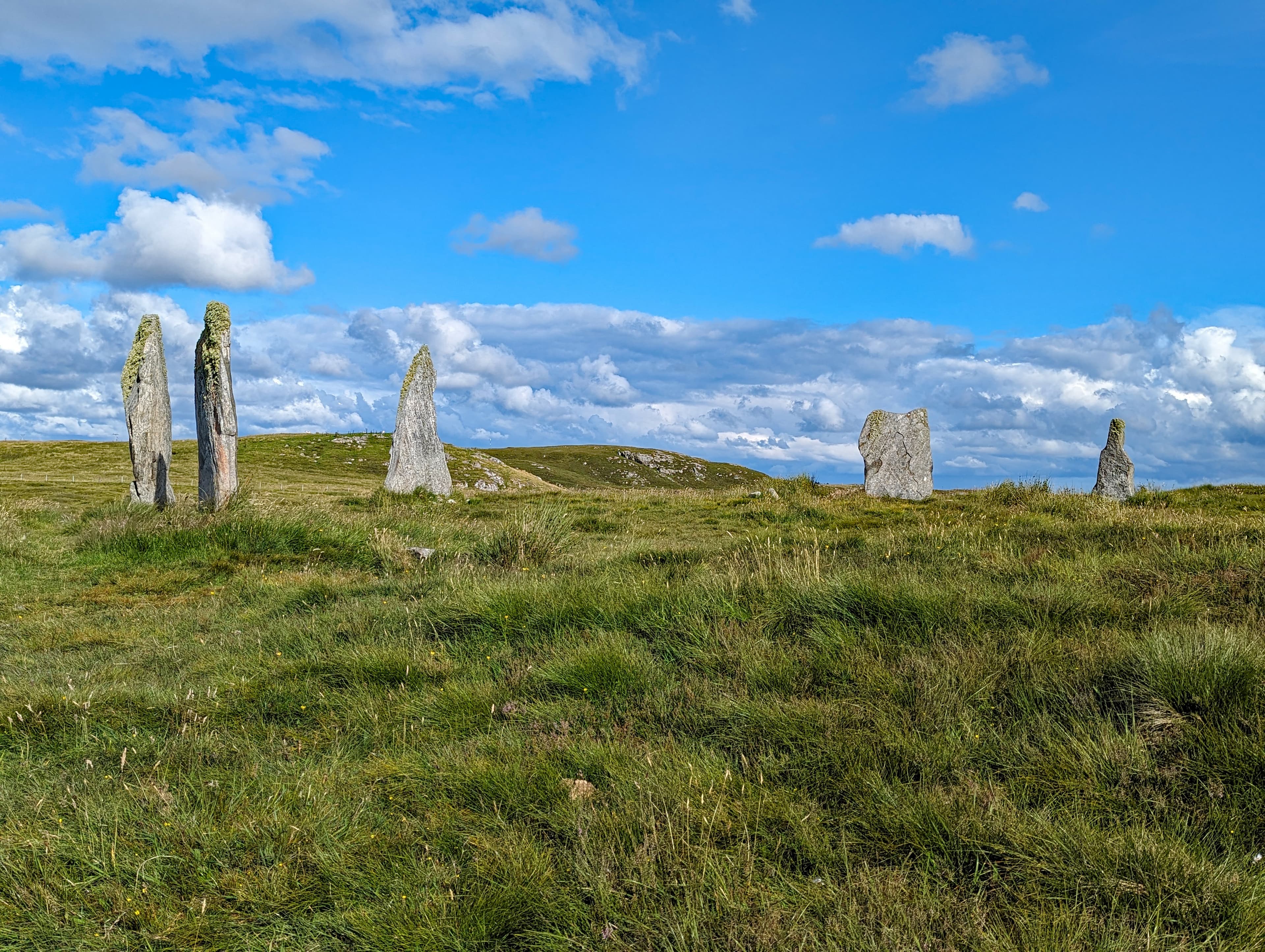
On a low ridge overlooking East Loch Roag, five standing stones and two fallen slabs trace an ellipse that once held ten uprights around a central cairn. Callanish II is the quieter sibling of the famous Callanish Stones, separated by a kilometre of open moorland but connected by five thousand years of shared purpose. Where Callanish I draws the crowds, this satellite circle offers something rarer: solitude among Neolithic stones, wind off the Atlantic, and the long view across water to the monuments that define this landscape.
The ridge comes first. Walking east from the main road along a short path, you climb gently onto a low spine of land that falls away toward the waters of East Loch Roag. The stones appear against the sky before you fully understand their arrangement. Five uprights, two fallen, thin slabs of Lewisian gneiss that absorbed three billion years of geological time before anyone thought to stand them on end.
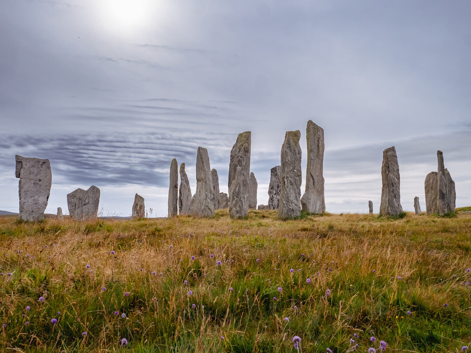
Callanish II is formally an ellipse, measuring 21.6 by 18.9 metres, which makes it nearly twice the diameter of the central ring at Callanish I. This is not a minor satellite. When all ten stones stood, with an eleventh outlier keeping watch, this was a substantial ceremonial space in its own right. A cairn 8.5 metres across occupies the centre, adding the dimension of the dead to whatever the living enacted here. Timber post holes discovered beneath the stone setting indicate that this ridge was ritually active before the stones arrived, possibly hosting a wooden circle ten metres in diameter. The place was chosen before the monument was built. Something about this particular ridge, this particular view, compelled attention.
The gneiss slabs range from two to over three metres in height. They are thin, elegant, their banded surfaces recording pressures and temperatures from deep within the early Earth. On grey days they absorb the light. When the sun breaks through Hebridean cloud, they glow. The stone that once stood among them but was removed to Lews Castle in Stornoway is a reminder that monuments are not static. Stones move. People take them. The circle endures, diminished but present.
From the ridge, you can see Callanish I to the northwest and Callanish III to the south. The three circles form a triangle across the landscape, each visible from the others, each contributing to a ceremonial geography that operated for at least fifteen hundred years. Standing at Callanish II, you occupy one vertex of that triangle. The wind carries across open water. The stones stand or lie as they have since before written language reached these shores. The silence here is not empty. It is the silence of a place that has been listened to for a very long time.
Context and lineage
The story of Callanish II begins before the stones. At some point during the late Neolithic, perhaps around 3000 BCE or earlier, people dug holes on this ridge above Loch Roag and set timber posts into the ground in a circle roughly ten metres across. The posts would have been visible from the water and from the ridge where Callanish I was already being planned or built. Whatever gatherings took place within the timber circle, they were considered significant enough that when the posts eventually rotted or were removed, the community replaced them with something more permanent.
The stone ellipse took shape over the centuries that followed. Ten slabs of Lewisian gneiss were selected from the local landscape, shaped minimally if at all, transported to the ridge, and raised into an elliptical setting approximately twenty-two by nineteen metres. An eleventh stone stood apart as an outlier. The choice of an ellipse rather than a true circle may have been deliberate, perhaps tracking an astronomical alignment or reflecting a different ceremonial geometry from the circles at Callanish I and III. Or it may simply reflect the natural contour of the ridge.
At some later point, a cairn 8.5 metres in diameter was constructed within the ellipse. This addition changed the character of the space, introducing the dead into what may have been a purely ceremonial enclosure. Similar cairn insertions occurred at Callanish I and at stone circles across Scotland, suggesting a widespread shift in ritual practice during the transition from the late Neolithic to the early Bronze Age.
Eventually the ceremonies ceased. The reasons are unknown. Peat began to accumulate, slowly burying the lower portions of the stones. For thousands of years the site stood on its ridge, progressively absorbed into the bog, its original scale hidden. When Sir James Matheson ordered the peat stripped from the Callanish monuments in the mid-nineteenth century, the full dimensions of Callanish II emerged for the first time in millennia.
Callanish II belongs to the stone circle tradition of the British Neolithic and early Bronze Age, a practice of communal monument building that produced thousands of stone settings across the British Isles and Brittany between approximately 3500 and 1500 BCE. Within this broader tradition, the Callanish complex represents one of the most significant concentrations of megalithic monuments in northern Europe. The complex includes at least thirteen known stone settings scattered across the landscape around Loch Roag. Callanish II's elliptical form connects it to a subset of stone settings that deviate from the circular norm, though whether this represents a regional variation, a chronological development, or a functional distinction remains debated. The use of Lewisian gneiss, the oldest rock type exposed at the Earth's surface, gives the Callanish monuments a material distinctiveness shared by few other megalithic sites.
Sir James Matheson
Henry Callender
Patrick Ashmore
Calanais Virtual Reconstruction Project
Why this place is sacred
Callanish II operates through a convergence of elements that together produce a quality of presence difficult to account for rationally. The ridge-top position places you between earth and sky with water on either side. The stones are Lewisian gneiss, among the oldest exposed rock on the planet, three billion years compressed into thin slabs that human hands raised five thousand years ago. The temporal scale defeats comprehension. You stand in a space defined by stone older than complex life, erected by people whose names and languages have been lost, in a landscape that still looks much as it did when the last stone was heaved upright.
The timber post holes add a layer of depth that is easy to miss but important to absorb. Before the stones, there were wooden posts. Before the permanent monument, there was a temporary one. The impulse to mark this ridge as significant preceded the technology of permanence. Whatever drew people here operated before the stone ellipse existed. The stones formalised something already felt.
The intervisibility with Callanish I and III creates what might be called a relational thinness. No single circle contains the full meaning of the landscape. Each references the others. Standing within the ellipse at Callanish II, you are aware of the greater complex around you, of being within a system rather than at a single point. The ridge amplifies this awareness. You can see in all directions. The horizon is water and mountain and the profile of Cailleach na Mointeach, the Old Woman of the Moors, whose reclining figure the Neolithic builders may have read as the body of the landscape itself.
The quiet is perhaps the most immediate factor. Callanish I receives thousands of visitors annually. Callanish II, a fifteen-minute walk away, is frequently empty. The absence of other people at a five-thousand-year-old monument produces a particular quality of attention. There is nothing between you and the stones, nothing between you and whatever the stones were placed here to attend to.
The site's original purpose remains a matter of informed speculation. The timber circle suggests an early phase of ceremonial gathering. The stone ellipse formalised the space. The central cairn introduced funerary rites, connecting the ceremonies of the living to the presence of the dead. The intervisibility with Callanish I and III suggests coordinated ritual activity across the landscape, possibly involving processional movement between sites during seasonal or astronomical events. The ridge-top position with its panoramic views would have served horizon astronomy, though no specific alignment distinct from those associated with Callanish I has been conclusively demonstrated.
The monument was gradually buried under accumulating peat over millennia. In the mid-nineteenth century, Sir James Matheson, then owner of Lewis, ordered large-scale peat removal from the Callanish sites, revealing the true scale of the stone circles to modern eyes. The exact date varies between sources: 1848, 1857, and shortly after 1857 are all cited. Henry Callender documented the excavation, recording the post holes and pebble-lined features found at the site. One stone was removed to Lews Castle in Stornoway at some point during this period. The site was scheduled as an Ancient Monument on 2 November 1992 and is now managed by Historic Environment Scotland as part of the broader Callanish complex. The Calanais Virtual Reconstruction Project, led by the University of St Andrews with Urras nan Tursachan and the University of Bradford, has contributed to understanding the wider prehistoric landscape, revealing additional monuments still hidden beneath the peat.
Traditions and practice
The original practices conducted within the stone ellipse are unknown. The timber-to-stone transition suggests evolving ceremonial traditions over centuries. The central cairn indicates that funerary rites were conducted within the circle at some stage, connecting ceremonies for the living to the presence of the ancestral dead. The intervisibility with Callanish I and III implies coordinated ritual activity across the landscape, possibly involving processional movement between sites during seasonal or astronomical events. The broader Callanish complex is associated with Gaelic traditions of midsummer and May Day visits, though these customs are primarily linked to Callanish I.
No formal ceremonies are conducted at Callanish II. The site functions as an open-access heritage monument within the broader Callanish landscape. Some visitors time their visits to solstices, equinoxes, or Celtic festival dates. Contemporary spiritual practitioners occasionally use the site for meditation or personal ritual, drawn by its quiet atmosphere and the intimate scale of the stone setting. The Callanish Walk circular route connects Callanish I, II, and III, creating a modern pilgrimage path through the prehistoric landscape.
Begin at the Calanais Visitor Centre if you wish to understand the archaeological context before walking to the site. The interpretation displays provide background that enriches the direct encounter with the stones.
Walk the path to Callanish II slowly. The transition from road to open ground is part of the experience. As the ridge rises beneath your feet, notice how the view opens. The stones will appear as silhouettes first. Let them resolve gradually rather than rushing toward them.
At the ellipse, pause before entering. Observe the arrangement from outside. Note the gaps where stones once stood. The circle remembers its own completeness even in diminished form.
Step inside. Move to the central cairn and stand near it. Turn slowly through a full rotation. Identify Callanish I to the northwest across the water. Find Callanish III to the south. You are standing within a network of monuments that once operated as a single ceremonial system.
Spend time with individual stones. Each slab of gneiss has its own character, its own pattern of banding, its own relationship to the light. Touch is not prohibited, but approach the stones with the awareness that they have stood here for five millennia and carry the accumulated weather of that duration.
If conditions allow, sit within the ellipse for an extended period. Ten minutes of stillness will reveal aspects of the site that a shorter visit cannot. The wind changes. The light shifts. Birds cross the sky. The stones remain. This contrast between movement and permanence is one of the qualities that makes the site what it is.
For the fullest experience, walk from Callanish II to Callanish III and then to Callanish I, experiencing the landscape as a connected whole rather than a collection of separate monuments.
Neolithic Ceremonial Practice
HistoricalCallanish II was part of a major Neolithic ritual landscape that developed over at least 1,500 years on the shores of Loch Roag. The discovery of timber post holes beneath the stone ellipse indicates the location was sacred before the stones were raised, representing deep continuity of ceremonial use from approximately 3000 BCE.
Original practices are unknown. The timber-to-stone transition suggests evolving ceremonial traditions. The central cairn indicates funerary rites were conducted within the circle. The intervisibility with Callanish I and III suggests coordinated ritual activity across the landscape.
Gaelic Cultural Tradition
ActiveThe Gaelic name Cnoc Ceann a' Gharaidh preserves a landscape understanding of the site within local settlement patterns. The broader Callanish complex is known as Fir Bhreige (False Men) or Tursachan (Standing Stones) in Gaelic tradition, with legends of giants turned to stone by St Kieran.
The broader Callanish complex is associated with midsummer and May Day visits in Gaelic tradition. Seasonal gatherings and cultural connection to the stones persist in the community memory of Lewis.
Lunar Standstill Observation
ActiveThe Callanish landscape is oriented toward the major lunar standstill, a phenomenon occurring every 18.6 years when the moon traces its most extreme path across the southern horizon, appearing to skim along the profile of Cailleach na Mointeach. While primarily associated with Callanish I, Callanish II's position within the same landscape means it participates in this astronomical tradition.
Gatherings and observations during the major lunar standstill at the Callanish complex. The ridge-top position of Callanish II provides distinctive horizon views relevant to observational astronomy.
Heritage Stewardship and Contemplative Visiting
ActiveSince the peat removal of the mid-nineteenth century and the site's scheduling as an Ancient Monument in 1992, Callanish II has been maintained as part of Scotland's protected heritage. Historic Environment Scotland manages the site. The Callanish Walk circular route connects Callanish I, II, and III, creating a modern pilgrimage path through the prehistoric landscape.
Heritage conservation, archaeological research, public interpretation, contemplative visiting, and walking pilgrimage between the stone circles. Contemporary spiritual practitioners use the site for meditation and personal reflection.
Experience and perspectives
From the Calanais Visitor Centre at Callanish I, you head east along the A858 for roughly three hundred metres, then turn right onto a minor road. A short signposted path leads to the stone circle on its ridge. The walk takes ten to fifteen minutes and serves as a transition. The visitor centre, with its interpretation panels and cafe, belongs to one mode of engagement. The path across open ground belongs to another.
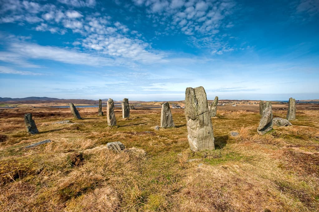
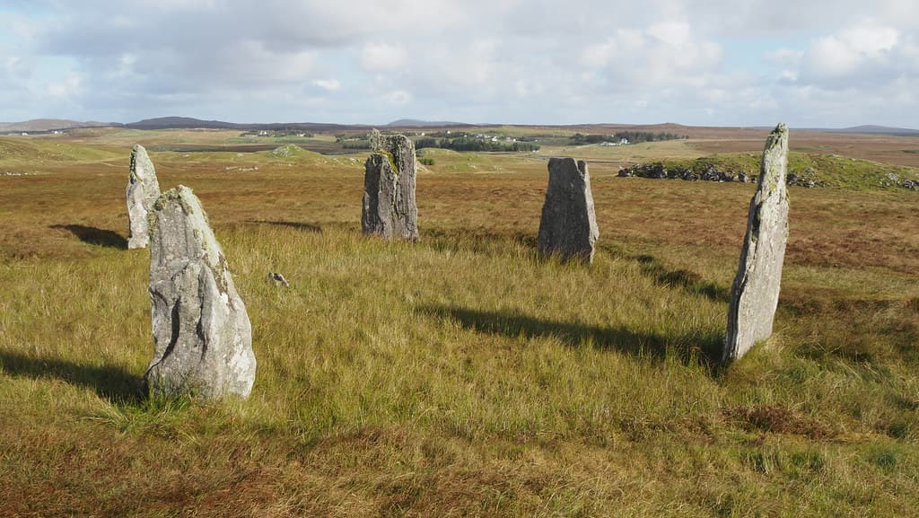
The ridge reveals itself gradually. The stones appear first as silhouettes, thin uprights against the Hebridean sky. As you approach, the elliptical arrangement becomes apparent. Five stones stand. Two lie where they fell or were toppled. The gaps where three missing stones once stood are palpable. You can sense the shape the circle wants to be, the completeness it almost achieves.
Enter the ellipse. The surviving stones define a space large enough to feel open but contained enough to feel intentional. The central cairn, 8.5 metres across, occupies the middle ground. Its surface is rough and grassy now, giving little outward sign of whatever burial or deposit it once held. Stand near it and turn slowly. To the northwest, across the water and the moor, the distinctive cruciform shape of Callanish I is visible. To the south, the double ring of Callanish III sits on lower ground. You are in the middle of a conversation between monuments.
The stones themselves repay close attention. Lewisian gneiss is not uniform. Each slab carries its own pattern of banding, its own record of metamorphic pressures endured billions of years before humans existed. Run your eyes along the surface. The grain of the stone catches light differently as the day turns. On overcast days, the gneiss is sombre and dark. When the sun emerges, the minerals flash. After rain, the stone surfaces darken and the banding becomes more distinct.
The wind is a constant companion on the ridge. It comes off the Atlantic, crosses Loch Roag, and finds nothing to break it before reaching you. This is not incidental to the experience. The Neolithic builders of this circle lived with this wind. Their ceremonies were conducted in it. Whatever words were spoken here were spoken into wind. To stand within the ellipse on a blustery day is to share a physical condition with the people who raised these stones.
If you have time, continue south to Callanish III, roughly five hundred metres away. Walking between the circles on the open moor gives a sense of the landscape as a connected whole. The Callanish Walk, a circular route linking all three major sites, takes two to three hours and is the fullest way to experience the ritual landscape.
Callanish II occupies a ridge approximately 90 metres from the waters of East Loch Roag. The ellipse is oriented roughly north-south along its longer axis. The site is positioned approximately 1.2 kilometres southeast of Callanish I and 500 metres north of Callanish III. The ridge provides elevated views in all directions, with Loch Roag to the west, the moor extending east, and the mountain profile of Cailleach na Mointeach visible along the southern horizon.
Callanish II is understood through several interpretive lenses, each illuminating different aspects of the monument and its place within the broader Callanish landscape.
Archaeological investigation has established Callanish II as a significant component of a major Neolithic ritual landscape. The discovery of timber post holes beneath the stone ellipse demonstrates that the location was used for ceremonial purposes before the stones were erected, possibly as a timber circle approximately ten metres in diameter. The stone ellipse of approximately ten stones, of which seven survive, was subsequently constructed, and a cairn 8.5 metres in diameter was built within it. The site's dimensions, at 21.6 by 18.9 metres, make it nearly twice the diameter of the central circle at Callanish I, challenging any assumption that Callanish II was a lesser monument. Patrick Ashmore's excavations at the broader Callanish complex between 1979 and 1988 placed the satellite circles within a coherent landscape interpretation. The Calanais Virtual Reconstruction Project has expanded understanding of the wider prehistoric context, revealing evidence of additional monuments still buried beneath the peat. Scholarly debate continues over the precise dating of the site, with no radiocarbon dates specific to Callanish II. The dating is inferred from the broader Callanish complex chronology, generally placed between approximately 3000 and 2000 BCE. Whether the timber post holes represent a pre-stone phase or a contemporaneous structure alongside the stones remains unresolved.
Gaelic-speaking communities of Lewis integrated the Callanish stone circles into their cultural landscape over centuries. The name Cnoc Ceann a' Gharaidh, meaning Hill at the End of the Enclosure or Garden Wall, preserves a practical understanding of the site's position within the local agricultural pattern. The broader Callanish complex is known in Gaelic as Fir Bhreige, the False Men, or Tursachan, Standing Stones. The legend holds that giants who refused to convert when St Kieran came to Lewis were turned to stone as punishment. The various stone circles represent different groups of these petrified giants. Other traditions speak of the Shining One who walks the avenue at Callanish I during midsummer, and of a white cow with red ears associated with the site. While these traditions centre on Callanish I, the satellite circles including Callanish II participate in the same cultural landscape and share its legendary associations.
Contemporary spiritual practitioners recognise the Callanish complex as one of the most powerful megalithic landscapes in northern Europe. Some interpret the multiple stone circles as nodes in an energy grid or ley line network. The lunar standstill alignment and the Cailleach na Mointeach landscape figure support interpretations focusing on goddess traditions and the sacred feminine. Callanish II's elliptical rather than circular form has attracted particular attention from those who read the shape as symbolically significant, sometimes interpreting the ellipse as a lunar or feminine geometry in contrast to the cruciform solar geometry of Callanish I. The ridge-top position, the water on either side, and the intervisibility with other circles are cited as evidence of deliberate sacred landscape design operating on principles not yet fully understood by conventional archaeology.
Fundamental questions remain unanswered about Callanish II. No radiocarbon dates specific to this site exist, so its chronology is inferred rather than directly established. The exact original number of stones is uncertain, with estimates ranging from eight to ten plus an outlier. Whether the elliptical form was intentional or a product of topography is unknown. The function of the timber circle that preceded the stones remains a matter of speculation. Whether Callanish II possessed its own astronomical alignments distinct from those associated with Callanish I has not been conclusively demonstrated. The nature of the ceremonies that connected the multiple stone circles, and whether processional movement between sites was a feature of the ritual practice, cannot be determined from the surviving evidence. The relationship between the living ceremonies of the stone ellipse and the dead interred in the central cairn remains one of the persistent mysteries of Neolithic monument studies.
Visit planning
Limited accommodation is available in Callanish village itself, including B&Bs and self-catering cottages. A wider range of options exists in Stornoway, approximately 12 miles east, including hotels, hostels, and guesthouses. Accommodation on Lewis fills quickly during summer months, so advance booking is strongly advised.
Respect the monument. Leave no trace. Allow other visitors the silence the site deserves.
Dress for exposed Hebridean weather regardless of the forecast. The ridge-top location is fully exposed to wind from any direction. Waterproof outer layers, warm mid-layers, and sturdy footwear with ankle support are the minimum. Conditions at the coast can be significantly different from conditions in Stornoway. Gloves and a hat are advisable outside high summer.
Photography is freely permitted and the site photographs exceptionally well. The thin standing stones against the Hebridean sky, the views across Loch Roag, and the relationship to the wider landscape all offer strong compositions. Dawn and dusk provide the most atmospheric light. The elevated position of the ridge allows photographs back toward Callanish I that convey the scale of the ritual landscape. Be mindful that other visitors may be seeking a contemplative experience and may not wish to appear in photographs.
The site is not traditionally associated with offerings. Presence and attentive engagement are sufficient. Do not leave crystals, coins, ribbons, or other objects at the stones. Such deposits, however well-intentioned, alter the character of the site and can damage the archaeological context.
Do not climb on the stones. Do not disturb or remove any stone, soil, or material from the site. Do not dig or probe the ground. Do not light fires. Leave no trace of your visit.
Plan your visit
Address
Isle of Lewis HS2 9DY, UK
Hours
Hours, fees, and access can change — verify on the official source before you travel. Practical details last checked Jun 2026.
Nearby sacred places
Sacred places within a half-day’s reach. Pilgrims often visit them together: walk one, stay for the other.

References
Sources consulted when researching this page. Independent verification by readers is welcome.
- 01Callanish 2 [Cnoc Ceann a'Gharraidh, Calanais II] — The Megalithic Portalhigh-reliability
- 02Calanais Standing Stones — Historic Environment Scotlandhigh-reliability
- 03Facts, Legend & History — Calanais Visitor Centrehigh-reliability
- 04Lewis, Callanish, 'tursachan' — Canmore (HES)high-reliability
- 05New discoveries in the Neolithic landscape of the Callanish Stones — Current Archaeologyhigh-reliability
- 06Callanish II — Wikipedia
- 07Callanish Stones — Wikipedia
- 08Calanais II (Cnoc Ceann a' Ghàrraidh) — Visit Outer Hebrides
- 09Cnoc Ceann a'Gharraidh Stone Circle — Isle of Albion
- 10Cnoc Ceann à Gharaidh stone circle — Stone Pages
Key questions
What pilgrims usually ask
- Why is Callanish II Stone Circle considered sacred?
- Visit Callanish II (Cnoc Ceann a' Gharaidh), a Neolithic stone ellipse on Lewis. Free access, Loch Roag views, part of the Callanish complex.
- What should I wear at Callanish II Stone Circle?
- Dress for exposed Hebridean weather regardless of the forecast. The ridge-top location is fully exposed to wind from any direction. Waterproof outer layers, warm mid-layers, and sturdy footwear with ankle support are the minimum. Conditions at the coast can be significantly different from conditions in Stornoway. Gloves and a hat are advisable outside high summer.
- Can I take photos at Callanish II Stone Circle?
- Photography is freely permitted and the site photographs exceptionally well. The thin standing stones against the Hebridean sky, the views across Loch Roag, and the relationship to the wider landscape all offer strong compositions. Dawn and dusk provide the most atmospheric light. The elevated position of the ridge allows photographs back toward Callanish I that convey the scale of the ritual landscape. Be mindful that other visitors may be seeking a contemplative experience and may not wish to appear in photographs.
- How long should I spend at Callanish II Stone Circle?
- 1 hour including the walk from the road and time to appreciate the views and landscape connections
- What offerings are appropriate at Callanish II Stone Circle?
- The site is not traditionally associated with offerings. Presence and attentive engagement are sufficient. Do not leave crystals, coins, ribbons, or other objects at the stones. Such deposits, however well-intentioned, alter the character of the site and can damage the archaeological context.
- What etiquette should visitors follow at Callanish II Stone Circle?
- Respect the monument. Leave no trace. Allow other visitors the silence the site deserves.
- What is the history of Callanish II Stone Circle?
- The story of Callanish II begins before the stones. At some point during the late Neolithic, perhaps around 3000 BCE or earlier, people dug holes on this ridge above Loch Roag and set timber posts into the ground in a circle roughly ten metres across. The posts would have been visible from the water and from the ridge where Callanish I was already being planned or built. Whatever gatherings took place within the timber circle, they were considered significant enough that when the posts eventually rotted or were removed, the community replaced them with something more permanent. The stone ellipse took shape over the centuries that followed. Ten slabs of Lewisian gneiss were selected from the local landscape, shaped minimally if at all, transported to the ridge, and raised into an elliptical setting approximately twenty-two by nineteen metres. An eleventh stone stood apart as an outlier. The choice of an ellipse rather than a true circle may have been deliberate, perhaps tracking an astronomical alignment or reflecting a different ceremonial geometry from the circles at Callanish I and III. Or it may simply reflect the natural contour of the ridge. At some later point, a cairn 8.5 metres in diameter was constructed within the ellipse. This addition changed the character of the space, introducing the dead into what may have been a purely ceremonial enclosure. Similar cairn insertions occurred at Callanish I and at stone circles across Scotland, suggesting a widespread shift in ritual practice during the transition from the late Neolithic to the early Bronze Age. Eventually the ceremonies ceased. The reasons are unknown. Peat began to accumulate, slowly burying the lower portions of the stones. For thousands of years the site stood on its ridge, progressively absorbed into the bog, its original scale hidden. When Sir James Matheson ordered the peat stripped from the Callanish monuments in the mid-nineteenth century, the full dimensions of Callanish II emerged for the first time in millennia.
- Who is associated with Callanish II Stone Circle?
- Sir James Matheson, Henry Callender, Patrick Ashmore, Calanais Virtual Reconstruction Project