Callanish Stone Circle III
A double stone ring on a Lewis hilltop, aligned to the moon's furthest journey north
Callanish, United Kingdom
Plan this visit
Practical context before you go
1-2 hours for the walk from the car park via Callanish II to Callanish III and return
Respect the Scheduled Ancient Monument. Do not climb or damage the stones. Dress for Hebridean weather. Leave no trace.
At a glance
- Coordinates
- 58.1956, -6.7241
- Type
- Stone Circle
- Suggested duration
- 1-2 hours for the walk from the car park via Callanish II to Callanish III and return
Pilgrim tips
- Dress for exposed Hebridean conditions. Weather on Lewis is highly changeable, with wind, rain, and sun occurring within the same hour. Waterproof outer layers, warm base layers, and sturdy waterproof footwear are essential. The walk crosses open moorland with no shelter between the car park and the stone circle.
- Photography is permitted and welcomed. The double concentric ring can be effectively photographed from within and from the surrounding ridge. Dawn and dusk light on the Lewisian gneiss creates striking textures and shadows. The intervisibility with the main Callanish complex to the northwest can be captured from the hilltop. Drone use should follow current Civil Aviation Authority regulations and avoid disturbing other visitors or wildlife.
- The path crosses open moorland which can be boggy and uneven. Sturdy waterproof footwear is essential. Weather on Lewis changes rapidly. There are no facilities at the stone circle itself. The walk requires moderate fitness and is not accessible for wheelchair users or those with significant mobility limitations.
Overview
On a low ridge southeast of the main Callanish Stones, a double concentric ring of Lewisian gneiss has stood for nearly five thousand years. Callanish Stone Circle III is one of at least a dozen satellite monuments in a Neolithic landscape that stretches across the west coast of Lewis. Smaller and quieter than its famous neighbour, this circle was built with precision: its stones track the moonset at the northern extreme of the major lunar standstill, an event that occurs once every 18.6 years.
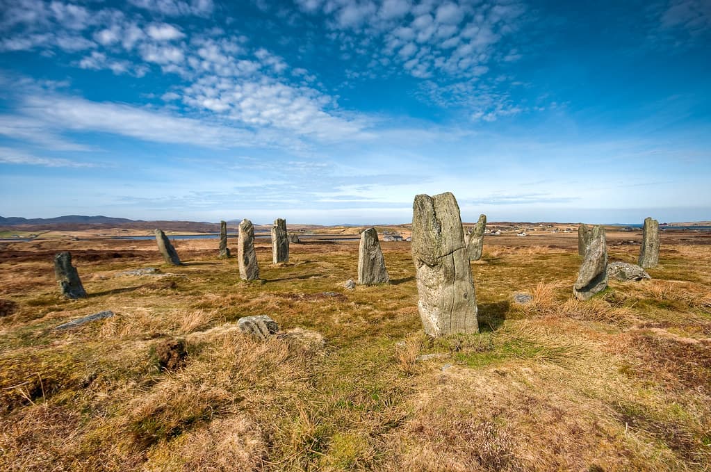
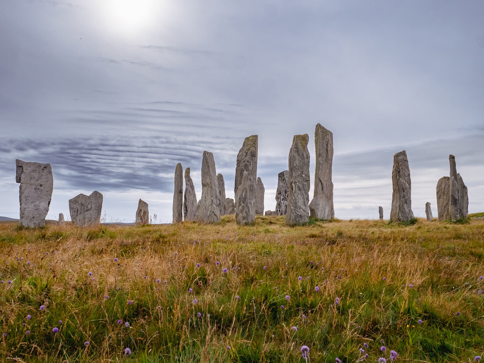
The walk matters. From the Callanish car park, you pass the main standing stones with their dramatic cruciform avenue, continue southeast past Callanish II on its lower knoll, and climb gradually over open moorland until a second circle appears on the ridge ahead. This is Callanish III, known in Gaelic as Cnoc Fhillibhir Bheag. It is not large. The outer ring measures roughly fourteen metres across, the inner ring half that. Eight stones of the outer setting remain upright, five have fallen. Four stones stand in the inner ring. All are Lewisian gneiss, the oldest rock in Britain at approximately three billion years old, banded and textured by deep geological time.
What this circle lacks in scale it compensates for in specificity. Gerald and Margaret Ponting identified an alignment to moonset at the northern extreme of the major lunar standstill, at approximately 354 degrees azimuth. This means the monument was not placed casually on the ridge. It was positioned to observe a rare celestial event visible only for a brief window every 18.6 years, when the moon sets at its most northerly point on the horizon. The double concentric ring, with its inner group of four stones variously interpreted as a cove or a second circle, suggests layered zones of activity within the monument.
Standing here, you are not at a single monument. You are within a sacred landscape. The main Callanish Stones are visible to the northwest. Callanish II lies downslope. Other satellite circles and standing stones are scattered across the moor. The Neolithic communities who built these monuments understood this place as a connected whole, and Callanish III was one node in a network of stone, sky, and intention that spanned several kilometres of Lewis moorland.
Context and lineage
Sometime around 2900 to 2600 BCE, communities on the Isle of Lewis selected a low ridge southeast of their principal ceremonial site and erected a double ring of standing stones. The outer ring held at least thirteen stones. Within it, they placed a second, smaller setting of stones, creating nested enclosures on the hilltop. The stones were local Lewisian gneiss, quarried or gathered from outcrops nearby, and propped upright in their sockets with small boulders packed around the base.
The site was not chosen at random. The ridge offered clear sightlines to the north and northwest, and the monument was positioned to align with moonset at the northern extreme of the major lunar standstill, a celestial event occurring every 18.6 years. This alignment places Callanish III within a broader network of stone circles, standing stones, and other monuments that together formed what researchers have called the Callanish observatory complex. At least eleven satellite sites surround the main Callanish I monument, each apparently positioned with reference to specific astronomical events.
The circle remained in active use for perhaps 1,500 years, through the late Neolithic and into the Bronze Age. As the centuries passed, peat began to grow across the Lewis moorland, gradually burying the lower portions of the stones. By the medieval period, only the upper portions of the tallest stones were visible above the peat. When Sir James Matheson ordered peat clearance in the Callanish area after 1857, the full height of the stones and the fallen members of the circle were revealed for the first time in centuries.
Callanish Stone Circle III belongs to the stone circle tradition of Neolithic Britain, which produced monuments from Orkney to Cornwall over a period spanning roughly 3200 to 2000 BCE. Within this tradition, the Callanish complex on Lewis represents one of the most concentrated assemblages of stone circles in the British Isles, comparable in significance to Avebury and Stonehenge though distinct in character. The double concentric ring at Callanish III, with its inner cove-like setting, has parallels at Avebury's stone circles. The broader Callanish landscape, with its multiple satellite monuments positioned around a central complex, echoes patterns found at the Ring of Brodgar and Stones of Stenness in Orkney. The astronomical alignments connect the site to a research tradition stretching from Somerville's 1912 surveys through Thom's megalithic geometry to the Pontings' archaeoastronomical analysis.
Captain H. Boyle Somerville
Alexander Thom
Gerald and Margaret Ponting
Patrick Ashmore
Sir James Matheson
Why this place is sacred
The thinness of Callanish III operates through relationship. This is not a monument that stands alone. It exists because the main Callanish complex exists, because the other satellite circles exist, because the horizon to the north exists at precisely the angle where the moon sets at its furthest extreme. The thinness is relational, astronomical, and deeply embedded in landscape.
Consider what the builders knew. They understood that the moon does not follow the same path each month, that its arc shifts over a cycle lasting 18.6 years, and that at the extreme of this cycle it sets at a point on the horizon visible from this ridge. They then placed stones to mark that alignment. This is not simple observation. It is sustained, multigenerational attention to the sky, encoded in rock that is itself three billion years old. The human knowledge embedded in these stones spans perhaps a century of careful watching. The stones themselves span geological time beyond comprehension. Between these two scales of time, something opens.
The double concentric ring intensifies the sense of threshold. The outer ring defines a boundary. The inner ring defines a second, more intimate boundary within the first. To stand among the inner four stones is to occupy the centre of two nested enclosures, each made of the oldest rock in Britain, each placed with reference to a celestial event most people will witness no more than four or five times in a lifetime. The rarity of the lunar standstill gives the alignment a quality of patient waiting. For most of its existence, this circle has been between events, holding the memory of the last standstill and the anticipation of the next.
The hilltop setting removes you from the domestic world of Callanish village below. The wind from the Atlantic is constant. The moorland stretches in every direction, broken only by the stones of other monuments. The main Callanish complex is visible but distant enough that you are alone with this smaller, quieter circle. The intimacy is the point. Here, the encounter with Neolithic sacred architecture is not mediated by visitor centres, fences, or crowds. It is direct.
Callanish III was part of a Neolithic ceremonial landscape centred on the main Callanish I monument. The double concentric ring, with its astronomical alignment to the major lunar standstill moonset, indicates a specific observational function within the broader complex. The inner group of four stones may have served as a cove, a ritual focal point comparable to structures at Avebury. The site was likely active from approximately 2900 to 2600 BCE and continued in use into the Bronze Age.
Peat gradually covered the lower portions of the stones over millennia. In 1857, Sir James Matheson, proprietor of Lewis, ordered peat clearance from the main Callanish monument, and clearance at Callanish III followed shortly after, revealing the true height of the stones and exposing fallen stones previously hidden. Captain H. Boyle Somerville conducted the first accurate survey in 1912. Alexander Thom later measured the site and interpreted it as a Type A Flattened Circle. Patrick Ashmore's government-funded excavation programme between 1979 and 1988 established the broader chronology of the Callanish complex. The site is now a Scheduled Ancient Monument under the protection of Historic Environment Scotland.
Traditions and practice
The original Neolithic practices are unknown in detail but almost certainly involved observation of celestial events. The alignment to moonset at the northern extreme of the major lunar standstill indicates that specific ceremonies or gatherings took place at this circle during those rare astronomical windows. The double concentric ring may have defined different zones of ritual participation, with the inner cove or circle serving as a focal point for those leading ceremonies and the outer ring marking a secondary boundary. As part of the broader Callanish complex, the site would have participated in landscape-scale ceremonial practice spanning centuries of continuous use.
The site is visited as part of walking routes connecting the Callanish satellite circles. Archaeoastronomers visit to study and observe celestial alignments, particularly during lunar standstill years when the alignment can be directly witnessed. Contemporary pagans and spiritual practitioners visit for personal observance, especially at solstices and equinoxes. The relative solitude of the satellite circles, compared to the well-visited main Callanish Stones, attracts those seeking contemplative rather than touristic encounters with the Neolithic landscape.
Begin at the Callanish car park and walk the full circuit through the satellite circles. The walk itself is the practice. Moving through the landscape on foot, at the pace the terrain demands, is the closest available approximation to how the builders of these monuments experienced the distances between them.
At Callanish III, enter the outer ring and pause. Notice which stones are standing and which have fallen. Observe the banding and texture of the Lewisian gneiss, the way three billion years of geological history are visible on every surface. Move to the inner ring and stand among the four upright stones. The space is small. You are enclosed twice over, by the inner ring and the outer. Let the double enclosure register physically.
Look north toward approximately 354 degrees. This is the direction of the lunar standstill alignment. You are unlikely to witness the standstill itself, but you can stand where the alignment exists and consider the sustained observation required to identify it. Generations of watching the moon, noting its shifting path, recognising the extreme, and then encoding that knowledge in stone.
If time allows, visit at dawn or dusk. The low-angle Hebridean light transforms the gneiss, drawing out the mineral bands and casting long shadows from the stones across the moorland. Under moonlight, the circle takes on a different character entirely. The stones become silhouettes against the sky, and the astronomical purpose of the monument becomes viscerally apparent.
Neolithic Ceremonial Practice
HistoricalCallanish III was part of a major Neolithic ritual landscape on the west coast of Lewis. The stone circle complex, with at least eleven satellite sites surrounding the main Calanais I monument, indicates this area was a significant ceremonial focus from approximately 2900-2600 BCE. The double concentric ring design with its inner cove suggests specific ritual functions within the broader landscape.
Original practices are unknown. The astronomical alignment toward moonset at the northern extreme of the major lunar standstill suggests observation of celestial events was central to the site's function. The concentric double ring may have defined different zones of ritual activity.
Gaelic Cultural Memory
ActiveThe Gaelic-speaking communities of Lewis maintained cultural awareness of the stone circles across millennia. The broader Callanish complex is known as Tursachan and Fir Bhreig, with traditions of petrified giants and the Shining One. All satellite circles participate in this wider mythological landscape.
Traditional recognition of the stones as places of significance within the Lewis landscape. Oral traditions preserved through Gaelic-speaking communities across generations.
Archaeoastronomical Research
ActiveCallanish III has been the subject of significant archaeoastronomical research since Somerville's surveys in 1912. The Pontings identified the moonset alignment at the major lunar standstill. The site serves as a key observation point within the broader Callanish observatory complex.
Ongoing astronomical observation and research. The major lunar standstill, occurring every 18.6 years, draws researchers and enthusiasts. The Calanais Virtual Reconstruction Project at the University of St Andrews has conducted geomagnetic surveys to further understand the monument landscape.
Contemporary Spiritual Practice
ActiveModern spiritual seekers, pagans, and those drawn to megalithic sites recognise Callanish III as part of one of Europe's most significant prehistoric sacred landscapes. The intimate scale and relative solitude of the satellite circle offer a more personal encounter with Neolithic sacred architecture.
Meditative visits, walking between satellite circles as landscape pilgrimage, observation of solstices and equinoxes, and personal spiritual practice among the stones.
Experience and perspectives
The approach from Callanish village takes you past the main standing stones and through the heart of the Neolithic landscape. From the car park, follow the path southeast. You will pass Callanish II on its lower knoll to your left, a smaller circle that serves as a waypoint on the walk. Continue uphill across open moorland. The ground can be boggy in places and a stile provides access over a fence near the site. The walk takes perhaps fifteen to twenty minutes, depending on conditions and pace.
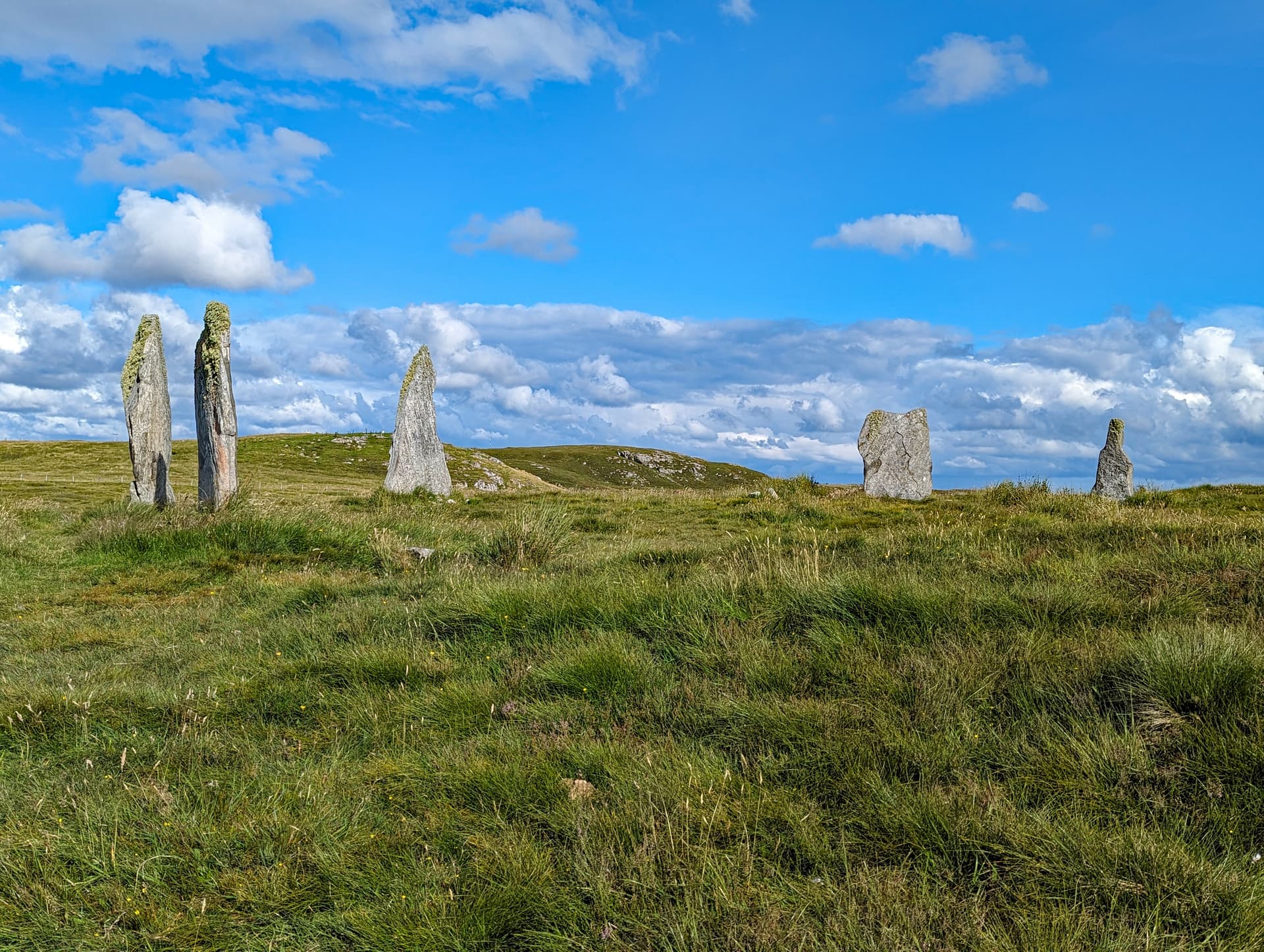
As you gain height, the ridge of Cnoc Fhillibhir Bheag comes into view. The stones appear gradually, resolving from the background of moor and sky. They are not tall. The highest stands about two metres, roughly human height. Most are shorter. But their arrangement is unmistakable: a ring within a ring, stones set in the earth with deliberate spacing.
Enter the outer ring first. Eight stones remain upright here, weathered and banded with the characteristic striations of Lewisian gneiss. This rock is among the oldest on Earth, formed approximately three billion years ago. Run your eye along the surface of any stone and you will see the geological record: bands of lighter and darker mineral compressed and folded over inconceivable time. The stones were not shaped. They were selected and placed as found, their natural forms incorporated into the monument's design.
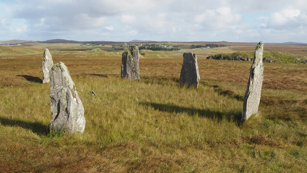
Move to the inner ring. Four stones stand here, closer together, defining a smaller space. Whether this inner group represents a concentric circle, a rectangular cove, or something else entirely remains debated. Stand among them. The outer ring surrounds you. The moorland surrounds the outer ring. The Atlantic horizon surrounds the moorland. Concentric enclosures at every scale.
Look northwest. The main Callanish Stones are visible on the horizon, their taller pillars distinguishable against the sky on clear days. Look north, toward approximately 354 degrees. This is the direction the Pontings identified as the alignment to moonset at the northern extreme of the major lunar standstill. On those rare occasions, perhaps once in a generation of sustained observation, the moon would have set precisely along this line of sight. Imagine the patience required to discover this. Imagine the significance once discovered.
The wind will be present. It is almost always present on Lewis. Let it be part of the experience rather than an obstacle to it. The stones have stood in this wind for nearly five millennia. The lichen on their surfaces has accumulated over centuries. The ground beneath your feet has been walked since the Neolithic. Nothing here requires hurrying.
Before leaving, turn slowly through a full circle. Count the monuments you can see or sense in the landscape. The main Callanish complex to the northwest. Callanish II downslope. The open moor with its hidden archaeology. You are standing at one point in a web of aligned stone that once covered this part of Lewis. The walk back to the car park completes a natural circuit through the sacred landscape.
Callanish Stone Circle III sits on the summit of Cnoc Fhillibhir Bheag, a low ridge approximately 50 feet above sea level, roughly 1 kilometre southeast of the main Callanish I Stones. Callanish II lies approximately 400 metres to the northwest and downslope, between this site and the main complex. The outer ring measures approximately 13.7 by 13.1 metres. The inner ring measures approximately 10.5 by 6.6 metres. The lunar standstill alignment faces approximately north-northwest at 354 degrees azimuth.
Callanish Stone Circle III is understood through overlapping lenses: archaeological science, archaeoastronomy, Gaelic cultural memory, and contemporary spiritual engagement. Each reveals a different dimension of why stones were placed on this hilltop five thousand years ago.
The scholarly consensus dates Callanish III to approximately 2900-2600 BCE, based on the broader chronology established by Patrick Ashmore's excavations of the Callanish complex between 1979 and 1988. The site consists of two concentric, unevenly oval stone settings: an outer ring of approximately 13.7 by 13.1 metres with thirteen original stones (eight standing, five fallen), and an inner ring of approximately 10.5 by 6.6 metres with four upright stones. The geometric layout has been interpreted as a Type A Flattened Circle by Thom and the Pontings, as a complex double ellipse in an alternative Thom interpretation, and as two concentric circles with an inner cove by the Royal Commission on the Ancient and Historical Monuments of Scotland. Gerald and Margaret Ponting identified the astronomical alignment to moonset at the northern extreme of the major lunar standstill at approximately 354 degrees azimuth, placing Callanish III within the broader archaeoastronomical framework of the Callanish complex. The site is documented in the Canmore national archaeological database as Site 4167 and is protected as a Scheduled Ancient Monument.
The Gaelic-speaking communities of Lewis maintained cultural awareness of the stone circles as significant places across millennia. The broader Callanish complex is known in Gaelic as Tursachan (standing stones) and the stones are called Fir Bhreig (False Men). According to tradition, they were once giants who refused to convert to Christianity and were turned to stone by St Kieran. Another tradition speaks of the Shining One who walks the avenue of the main Callanish Stones at midsummer. While these traditions centre on the larger Callanish I site, all the satellite circles, including Callanish III, participate in the same culturally recognised sacred landscape. The Gaelic place name Cnoc Fhillibhir Bheag, meaning the small hill of Fhillibhir, anchors the site within the Gaelic naming tradition of Lewis.
Contemporary spiritual seekers recognise the Callanish complex as one of the most energetically significant prehistoric landscapes in Europe. The concentration of stone circles in a small area is interpreted by some as evidence of powerful earth energies converging on this part of Lewis. The astronomical alignments are understood as evidence of sophisticated spiritual-scientific knowledge that integrated celestial observation with sacred architecture. The double concentric ring at Callanish III is sometimes interpreted as representing inner and outer spiritual realms or cycles of being. The relative solitude of the satellite circles, compared to the well-visited main site, attracts practitioners seeking unmediated personal encounter with the stones.
Fundamental questions remain unanswered. The precise function of the inner four-stone setting, whether cove, concentric ring, or something else, is unresolved. Why this particular hilltop was chosen for a double-ring monument, rather than a single ring like other satellites, is unknown. The relationship and hierarchy between the satellite circles and the main Callanish I complex remains a matter of interpretation. What specific ceremonies or observations took place during the lunar standstill is beyond recovery. Whether the satellite circles were built simultaneously as a planned network or sequentially over centuries cannot be determined from available evidence. Whether undiscovered monuments remain buried beneath the Lewis peat in the surrounding area awaits future survey and excavation.
Visit planning
Limited accommodation in Callanish village, including guesthouses and bed-and-breakfasts. A wider range of options is available in Stornoway, approximately 12 miles east. Booking well in advance is advisable during summer months, particularly July and August, when the Outer Hebrides receive their highest visitor numbers.
Respect the Scheduled Ancient Monument. Do not climb or damage the stones. Dress for Hebridean weather. Leave no trace.
Dress for exposed Hebridean conditions. Weather on Lewis is highly changeable, with wind, rain, and sun occurring within the same hour. Waterproof outer layers, warm base layers, and sturdy waterproof footwear are essential. The walk crosses open moorland with no shelter between the car park and the stone circle.
Photography is permitted and welcomed. The double concentric ring can be effectively photographed from within and from the surrounding ridge. Dawn and dusk light on the Lewisian gneiss creates striking textures and shadows. The intervisibility with the main Callanish complex to the northwest can be captured from the hilltop. Drone use should follow current Civil Aviation Authority regulations and avoid disturbing other visitors or wildlife.
There is no tradition of offerings at this site. Presence, attention, and careful observation are sufficient. Do not leave objects, flowers, crystals, or other items at the stones. The monument is an archaeological site and anything left behind becomes litter that must be removed.
Do not climb on the stones. Do not lean against, push, or interfere with the stones in any way. The monument is a Scheduled Ancient Monument and it is a criminal offence to damage it. Do not dig, probe, or remove anything from the site. Leave no trace. Close any gates or stiles behind you. Keep dogs under close control.
Plan your visit
Address
Isle of Lewis HS2 9DY, UK
Hours
Hours, fees, and access can change — verify on the official source before you travel. Practical details last checked Jun 2026.
Nearby sacred places
Sacred places within a half-day’s reach. Pilgrims often visit them together: walk one, stay for the other.

References
Sources consulted when researching this page. Independent verification by readers is welcome.
- 01Lewis, Callanish, Cnoc Fillibhir Bheag, 'Tursachan' — Canmore / RCAHMShigh-reliability
- 02Lewis, Callanish, Cnoc Fillibhir Bheag, 'Tursachan' — Trove Scotlandhigh-reliability
- 03Decoding the Callanish Complex - A Progress Report — Gerald Ponting and Margaret Pontinghigh-reliability
- 04Facts, Legend & History — Calanais Visitor Centrehigh-reliability
- 05Calanais Standing Stones — Historic Environment Scotlandhigh-reliability
- 06Callanish III — Wikipedia
- 07Callanish 3 [Cnoc Fillibhir Bheag, Callanish III] Stone Circle — The Megalithic Portal
- 08Calanais III (Cnoc Fhillibhir Bheag) — Visit Outer Hebrides
- 09Callanish III (Cnoc Filibhir Bheag) — Saints and Stones
- 10Calanais III — Ancient Scotland
Key questions
What pilgrims usually ask
- Why is Callanish Stone Circle III considered sacred?
- Visit Callanish Stone Circle III (Cnoc Fhillibhir Bheag) on the Isle of Lewis. A 5,000-year-old double stone ring aligned to the lunar standstill. Free access.
- What should I wear at Callanish Stone Circle III?
- Dress for exposed Hebridean conditions. Weather on Lewis is highly changeable, with wind, rain, and sun occurring within the same hour. Waterproof outer layers, warm base layers, and sturdy waterproof footwear are essential. The walk crosses open moorland with no shelter between the car park and the stone circle.
- Can I take photos at Callanish Stone Circle III?
- Photography is permitted and welcomed. The double concentric ring can be effectively photographed from within and from the surrounding ridge. Dawn and dusk light on the Lewisian gneiss creates striking textures and shadows. The intervisibility with the main Callanish complex to the northwest can be captured from the hilltop. Drone use should follow current Civil Aviation Authority regulations and avoid disturbing other visitors or wildlife.
- How long should I spend at Callanish Stone Circle III?
- 1-2 hours for the walk from the car park via Callanish II to Callanish III and return
- What offerings are appropriate at Callanish Stone Circle III?
- There is no tradition of offerings at this site. Presence, attention, and careful observation are sufficient. Do not leave objects, flowers, crystals, or other items at the stones. The monument is an archaeological site and anything left behind becomes litter that must be removed.
- What etiquette should visitors follow at Callanish Stone Circle III?
- Respect the Scheduled Ancient Monument. Do not climb or damage the stones. Dress for Hebridean weather. Leave no trace.
- What is the history of Callanish Stone Circle III?
- Sometime around 2900 to 2600 BCE, communities on the Isle of Lewis selected a low ridge southeast of their principal ceremonial site and erected a double ring of standing stones. The outer ring held at least thirteen stones. Within it, they placed a second, smaller setting of stones, creating nested enclosures on the hilltop. The stones were local Lewisian gneiss, quarried or gathered from outcrops nearby, and propped upright in their sockets with small boulders packed around the base. The site was not chosen at random. The ridge offered clear sightlines to the north and northwest, and the monument was positioned to align with moonset at the northern extreme of the major lunar standstill, a celestial event occurring every 18.6 years. This alignment places Callanish III within a broader network of stone circles, standing stones, and other monuments that together formed what researchers have called the Callanish observatory complex. At least eleven satellite sites surround the main Callanish I monument, each apparently positioned with reference to specific astronomical events. The circle remained in active use for perhaps 1,500 years, through the late Neolithic and into the Bronze Age. As the centuries passed, peat began to grow across the Lewis moorland, gradually burying the lower portions of the stones. By the medieval period, only the upper portions of the tallest stones were visible above the peat. When Sir James Matheson ordered peat clearance in the Callanish area after 1857, the full height of the stones and the fallen members of the circle were revealed for the first time in centuries.
- Who is associated with Callanish Stone Circle III?
- Captain H. Boyle Somerville, Alexander Thom, Gerald and Margaret Ponting, Patrick Ashmore, Sir James Matheson