Brough of Deerness Chapel
A Norse chapel on a wind-scoured sea stack, where pilgrims climbed cliff steps on their knees for a thousand years
Deerness, Orkney Islands, United Kingdom
Plan this visit
Practical context before you go
Two to three hours to explore the Brough thoroughly and walk the coastal path.
Park at the Mull Head Nature Reserve car park, off a minor road signposted from the B9050 in the Deerness area of East Mainland, Orkney. Kirkwall is approximately twenty-five minutes' drive. The coastal path to the Brough is roughly one kilometre. The final approach involves a steep descent and ascent on rock-cut steps with chain support. Not wheelchair accessible. Not suitable for those with vertigo or significant mobility limitations.
The Brough of Deerness is a freely accessible Scheduled Ancient Monument. The primary considerations are physical safety on the cliff approach and respect for the archaeological remains.
At a glance
- Coordinates
- 58.9639, -2.7050
- Type
- Chapel
- Suggested duration
- Two to three hours to explore the Brough thoroughly and walk the coastal path.
- Access
- Park at the Mull Head Nature Reserve car park, off a minor road signposted from the B9050 in the Deerness area of East Mainland, Orkney. Kirkwall is approximately twenty-five minutes' drive. The coastal path to the Brough is roughly one kilometre. The final approach involves a steep descent and ascent on rock-cut steps with chain support. Not wheelchair accessible. Not suitable for those with vertigo or significant mobility limitations.
Pilgrim tips
- No dress code. Sturdy walking boots or shoes with good grip are essential for the cliff path. Waterproof and windproof layers are strongly recommended.
- Photography is unrestricted. The dramatic cliff setting, chapel ruins, and panoramic sea views offer exceptional photographic opportunities.
- The cliff approach is genuinely steep and can be dangerous in wet, icy, or very windy conditions. Do not attempt the ascent if conditions feel unsafe. The chain may not support full body weight. This site is not suitable for those with vertigo, significant mobility limitations, or young children.
Overview
On the eastern tip of Orkney's Mainland, a grass-topped promontory rises from the North Sea, connected to the land by a narrow neck of eroded rock. Atop this natural fortress stand the foundations of a Norse-era chapel and the remains of some thirty buildings, a settlement that flourished between the tenth and twelfth centuries. The Brough of Deerness has drawn the faithful since at least the Pictish period, and pilgrims continued climbing its cliff steps, sometimes on their knees, into the nineteenth century. The physical effort of reaching the summit has always been part of the devotion.
The walk to the Brough of Deerness begins along Orkney's eastern coast, following a cliff-top path from the Mull Head car park. The North Sea is constant company. Seabirds wheel overhead. The path is exposed to weather in a way that prepares the body for what comes next.
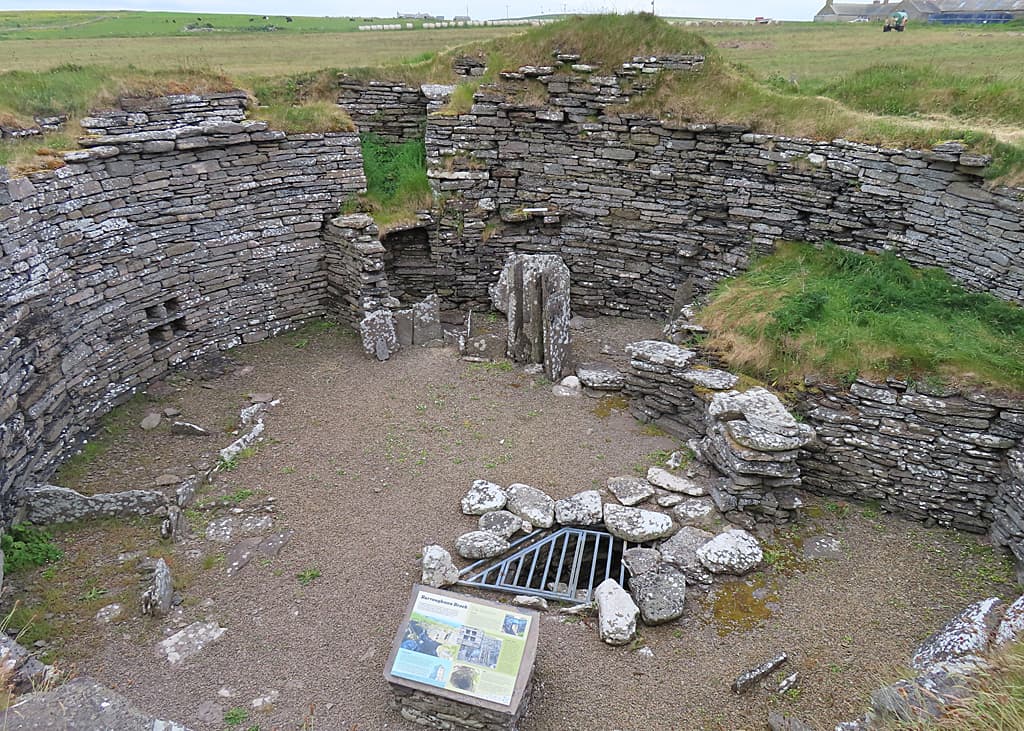
The Brough itself appears as a grassy headland separated from the mainland by a steep-sided gap. To reach the summit, you descend to a narrow rocky neck, then climb stone-cut steps with a chain bolted into the rock for support. The ascent is not dangerous in good conditions, but it demands attention, commitment, the use of hands as well as feet. Medieval pilgrims made this same climb on their knees.
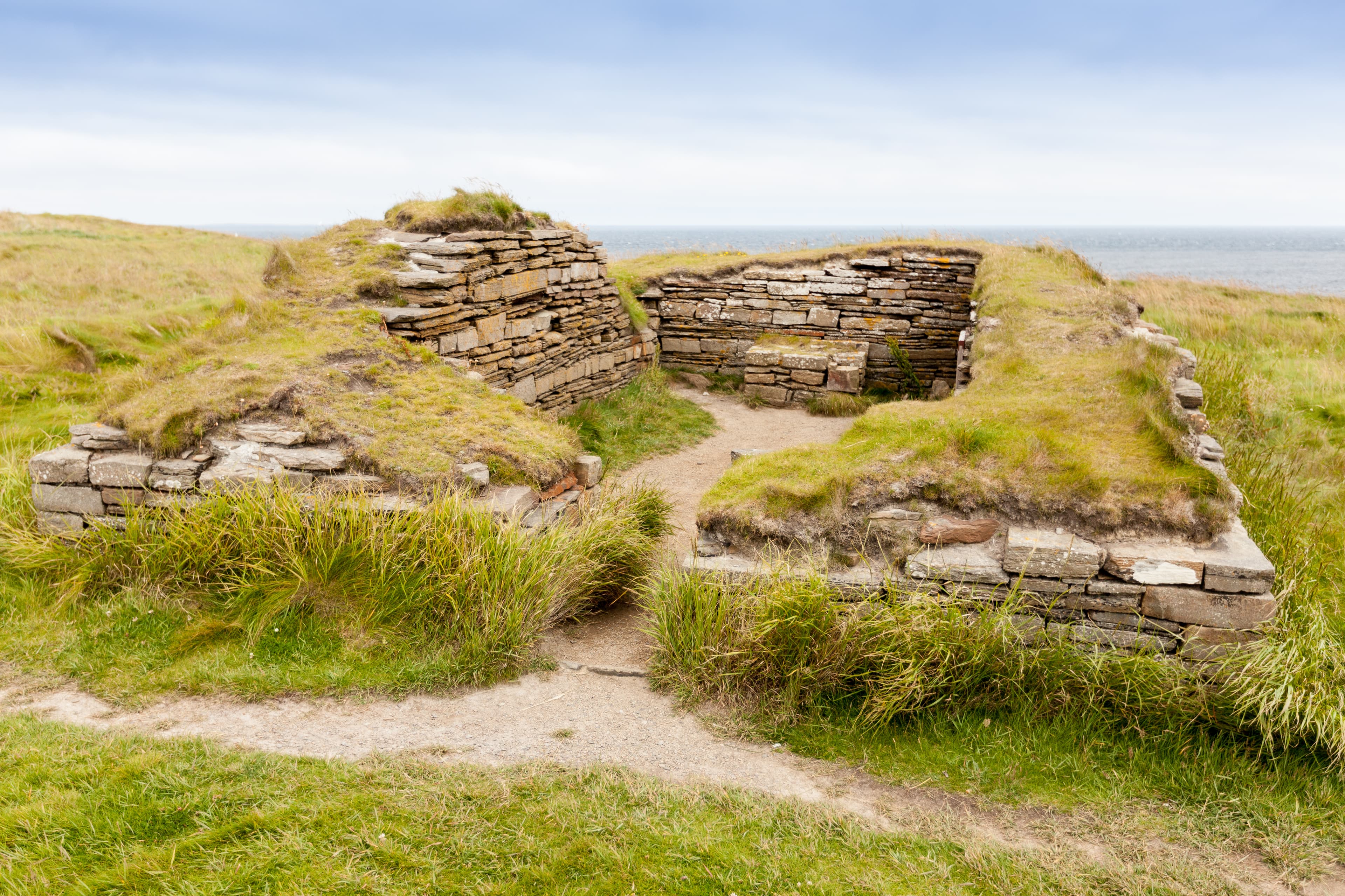
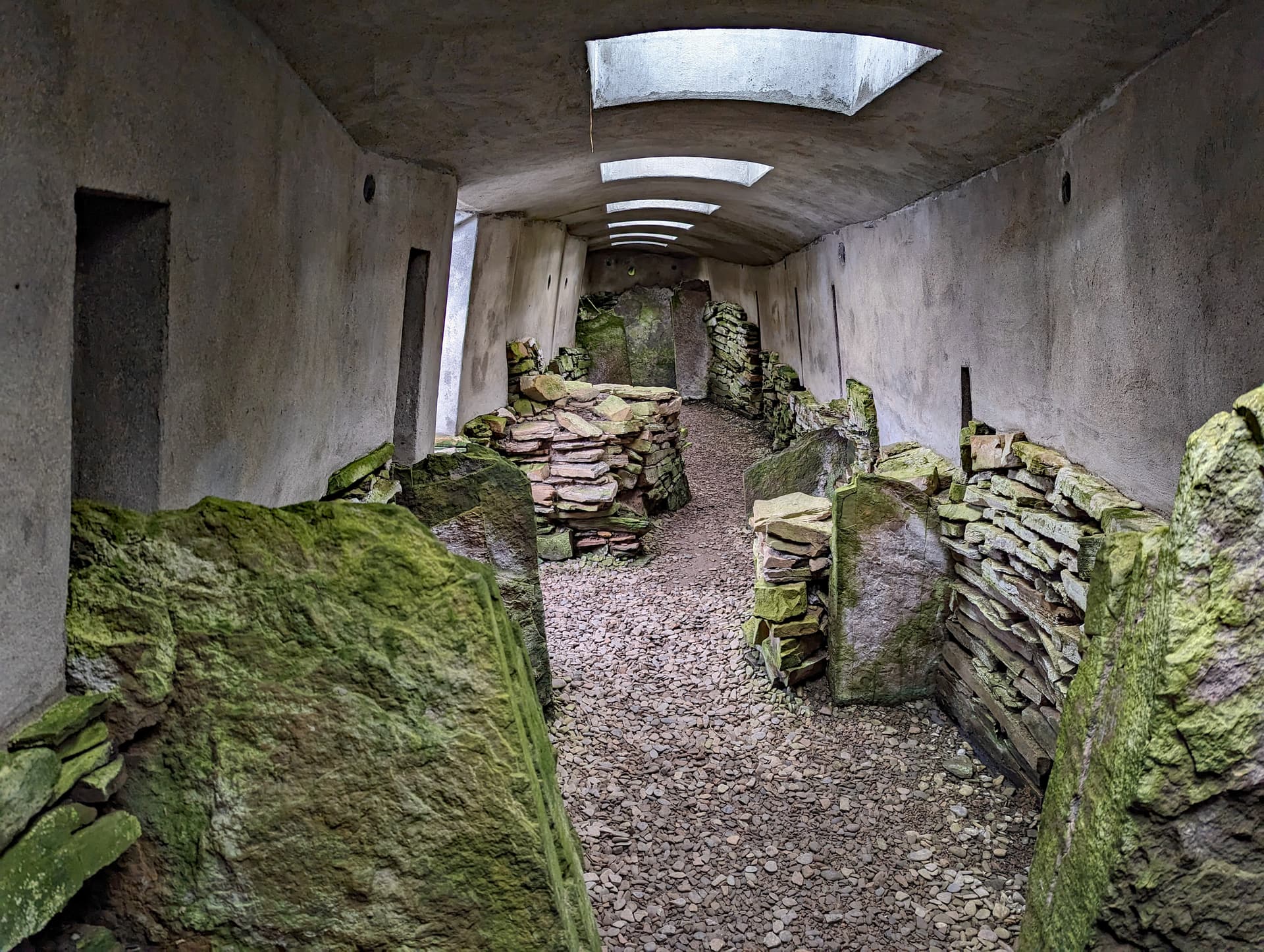
On top, the ground levels to a windswept plateau. The chapel foundations are visible as low stone walls forming a small rectangular building. Around it, the turf-covered outlines of approximately thirty Norse-era structures create a pattern of habitation. This was a community, not merely a church. Someone lived here, worked here, worshipped here, endured the wind and the isolation for reasons that mattered deeply to them.
Archaeological evidence reveals that the site was occupied before the Norse arrived. Radiocarbon dating of deposits beneath the visible buildings yields dates from the sixth and seventh centuries, the Pictish period. The Picts may have known this promontory as a place of spiritual retreat, its isolation recalling the Celtic Christian tradition of hermitage sites on exposed headlands and islands. When Norse settlers built their chapel here, perhaps in the mid-tenth century, they were claiming a site already sanctified by centuries of use.
A coin of the Anglo-Saxon king Eadgar, minted between 959 and 975, was found between the timber and stone phases of the chapel, providing a key dating marker. The stone chapel was rebuilt around 1100 and continued in use until the 1500s. But even after formal worship ceased, the site retained its hold. Thirty-eight coins recovered from the ruins date from 1642 to 1860, left as votive offerings by pilgrims who still made the cliff ascent centuries after the last service was held.
Context and lineage
No foundation legend survives for the chapel. Its origins are understood through archaeology rather than hagiography. The Pictish settlement predating Norse arrival suggests the location was recognised as significant before the Vikings came. The Norse chapel may have been built on or near an earlier Pictish religious site, representing cultural and spiritual continuity through conquest. The dedication of the chapel is unknown; no patron saint has been identified.
The site's lineage runs from Pictish settlement through Norse Christianity to post-medieval pilgrimage. The specific Pictish traditions are unrecoverable. Norse Christian worship at the chapel belongs to the broader pattern of Scandinavian conversion in the North Atlantic. The pilgrimage tradition, continuing to at least 1860 based on coin evidence, represents the longest documented continuity of sacred use at the site.
Christopher D. Morris
James H. Barrett
Why this place is sacred
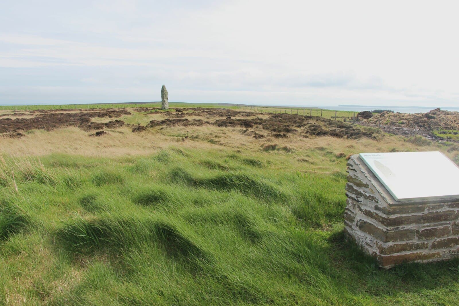
Thin places in Celtic and Norse Christian tradition are often located where land meets sea in dramatic fashion, where the boundary between elements mirrors the boundary between worlds. The Brough of Deerness exemplifies this pattern. The promontory is almost an island, connected to the mainland by a thread of eroded rock. To stand on its summit is to stand surrounded by sea on three sides, exposed to weather systems that arrive unobstructed from the Atlantic and the North Sea.
The climb itself creates a threshold experience. The descent to the rocky neck, the ascent of stone-cut steps, the use of a chain for support, these actions demand the kind of physical engagement that quiets the mind. Medieval pilgrims who climbed on their knees understood this instinctively: the body's effort was itself a form of prayer.
The antiquity of the site deepens its liminal quality. Pictish settlers chose this place in the sixth century, well before the Norse chapel was built. Something about this promontory, its isolation, its exposure, its dramatic separation from the mainland, marked it as significant across cultures and centuries. The Norse built their chapel here not on virgin ground but on a site already layered with meaning.
The presence of the dead adds another dimension. The settlement housed a community for centuries. People were born here, lived here, died here. The chapel served their spiritual needs, the small rectangular building the heart of their world. Standing among the ruins, you stand where generations stood, in a place that mattered enough to climb to, again and again, for over a thousand years.
The site's earliest purpose is debated. Pictish-era deposits suggest settlement from the sixth or seventh century, possibly connected to the Celtic Christian tradition of remote monastic retreat. The Norse chapel and settlement, dating from the tenth to twelfth centuries, are interpreted by most scholars as a chiefly stronghold with a private chapel, a combination of secular power and Christian devotion characteristic of the Norse conversion period.
The site evolved through several phases: Pictish settlement (sixth to ninth centuries), Norse timber chapel and settlement (tenth century), stone chapel rebuild (late tenth century onward, using the Eadgar coin as a terminus post quem), chapel reconstruction around 1100, continued use to the 1500s, and post-abandonment pilgrimage continuing to at least 1860. Each phase added to the site's accumulated sanctity.
Traditions and practice
The chapel served Norse Christian worship from the tenth through the sixteenth century. Pilgrims climbed the cliff steps, sometimes on their knees, and left votive coin offerings at the chapel. The settlement of approximately thirty buildings likely supported communal religious observance centred on the chapel. The specific liturgical practices are unknown, but would have followed the Norse Christian rites common in the North Atlantic during this period.
No organised religious ceremonies or pilgrimages take place at the site. Some visitors with spiritual interests treat the cliff ascent as an informal pilgrimage, conscious of echoing a practice that continued for centuries. The site is part of the Mull Head Nature Reserve walking circuit.
The climb to the summit is itself the primary practice this site offers. Allow it to be deliberate rather than hurried. On the summit, take time among the chapel ruins. The small rectangular space of the chapel can still be entered and occupied in imagination. Standing where the altar would have been, facing east into the sea, offers a particular quality of exposure and attention.
Pictish Christianity
HistoricalRadiocarbon dating of deposits beneath Norse-period buildings yields dates from the sixth to seventh centuries, placing the earliest occupation in the period of Pictish Christianisation in northern Scotland. The site's dramatically isolated position is consistent with the Celtic Christian tradition of remote monastic retreat on coastal headlands and islands.
Specific Pictish practices at the site are unknown. The isolation and coastal setting parallel other early Celtic Christian hermitage sites such as Skellig Michael and sites on Iona.
Norse Christianity
HistoricalThe chapel on the Brough of Deerness is one of the earliest Viking Christian sites in the North Atlantic. The Anglo-Saxon coin of Eadgar (959-975) found between the timber and stone chapel phases establishes the stone construction in the late tenth century. The surrounding settlement of approximately thirty buildings represents a significant Norse community, likely a chiefly stronghold where secular power and Christian devotion were intertwined.
Christian worship in a small rectangular chapel, supported by a resident community. The combination of chapel and chiefly residence reflects the political dimensions of Norse conversion, where adopting Christianity was both a spiritual and strategic act.
Medieval and Post-Medieval Pilgrimage
HistoricalPilgrimage to the Brough continued for centuries after the chapel ceased regular worship. Thirty-eight coins recovered from excavations, dating from 1642 to 1860, document two centuries of votive offerings by pilgrims who continued to climb the cliff path to the ruined chapel.
Pilgrims climbed the steep cliff steps, sometimes on their knees as an act of devotion, and left coin offerings at the chapel ruins. The physical challenge of the ascent was itself a devotional practice, a penitential act echoing broader traditions of arduous pilgrimage.
Experience and perspectives
From the Mull Head Nature Reserve car park, the coastal path runs east along the cliff tops. The walk takes roughly twenty minutes each way, with the sea below and seabirds above. The path is well-worn but exposed to weather.
The approach to the Brough announces itself with a dramatic view: the grass-topped promontory separated from the mainland by a narrow gap, the ruins visible as low mounds on the summit. The descent to the connecting neck requires care. Rock-cut steps, worn smooth by centuries of feet, lead down to the narrow causeway. A chain bolted into the rock provides support for the ascent on the far side.
The climb is short but steep. In wet conditions, the rock is slippery. In wind, balance requires attention. This is not a site that can be visited casually. The effort is the entry fee.
On the summit, the world opens. The North Sea stretches in three directions. The island of Copinsay is visible to the south. The chapel foundations, a small rectangular outline of stone walls, occupy the highest point. Around it, the humps and hollows of approximately thirty buildings create a settlement pattern visible in the turf. You can trace the outlines of individual structures, imagine rooms, doorways, the daily life of a Norse community a thousand years ago.
The wind is constant. There is no shelter. The grass is short, grazed by salt air and storms. Standing here, you understand why pilgrims came and why they climbed on their knees. The effort of reaching this place creates a severance from ordinary life that no architectural threshold could match.
Park at the Mull Head Nature Reserve car park, signposted from the B9050 in the Deerness area of East Mainland, Orkney. The coastal path runs approximately one kilometre east to the Brough. The full circuit, including the Brough, Mull Head, and the Gloup sea cave, makes a rewarding walk of two to three hours. The Italian Chapel at Lamb Holm and St Magnus Cathedral in Kirkwall are both within thirty minutes' drive.
The Brough of Deerness sits at the intersection of multiple interpretive frameworks: Pictish settlement studies, Norse conversion history, medieval pilgrimage traditions, and the archaeology of power. Each lens reveals different aspects of the site, and none provides a complete picture.
Two major excavation campaigns, Christopher Morris's 1975-1977 work on the chapel and James Barrett's 2008 investigations of the settlement, have established the site's chronology. Radiocarbon dating confirms Pictish-era occupation from the sixth or seventh century. A coin of Eadgar (minted 959-975) found between the timber and stone chapel phases provides a key dating horizon. Current scholarly interpretation favours the site as a chiefly stronghold with a private chapel rather than a monastic community, reflecting the political dimensions of Norse conversion to Christianity. The site is of national importance as Scheduled Monument SM4654. The chapel underwent at least two major building phases and was rebuilt around 1100.
No surviving oral tradition from the Pictish or Norse periods. The pilgrimage tradition, documented through coin evidence dating from 1642 to 1860, represents the most recent layer of sacred practice. Pilgrims climbed the cliff steps on their knees, a form of penitential devotion with parallels across Celtic and medieval Christian pilgrimage traditions.
Some writers on sacred landscape interpret the Brough's dramatic position as evidence of deliberate placement at a point of spiritual power. The promontory's natural fortress quality, its separation from the mainland, and its exposure to the elements are read as intentional features enhancing spiritual function rather than merely defensive considerations.
Major questions remain. Was the Pictish settlement a monastic community, a secular farm, or something else? Was there continuity between Pictish and Norse occupation, or a gap? What was the chapel's dedication? The full stratigraphic sequence beneath the Norse buildings has been only partially excavated. Whether the site held significance in pre-Christian Pictish religion is unknown.
Visit planning
Park at the Mull Head Nature Reserve car park, off a minor road signposted from the B9050 in the Deerness area of East Mainland, Orkney. Kirkwall is approximately twenty-five minutes' drive. The coastal path to the Brough is roughly one kilometre. The final approach involves a steep descent and ascent on rock-cut steps with chain support. Not wheelchair accessible. Not suitable for those with vertigo or significant mobility limitations.
Accommodation is available in the Deerness area and more extensively in Kirkwall. Self-catering options, B&Bs, and hotels are available on the Orkney Mainland.
The Brough of Deerness is a freely accessible Scheduled Ancient Monument. The primary considerations are physical safety on the cliff approach and respect for the archaeological remains.
No dress code. Sturdy walking boots or shoes with good grip are essential for the cliff path. Waterproof and windproof layers are strongly recommended.
Photography is unrestricted. The dramatic cliff setting, chapel ruins, and panoramic sea views offer exceptional photographic opportunities.
Historically, pilgrims left coins at the chapel. This practice is no longer appropriate at a protected archaeological site. Do not leave coins or other offerings.
Do not disturb, damage, or remove archaeological material. Keep dogs under control. Do not attempt the cliff ascent in dangerous weather conditions.
Plan your visit
Address
Deerness, Orkney KW17 2QJ, UK
Hours
Hours, fees, and access can change — verify on the official source before you travel. Practical details last checked Jun 2026.
Nearby sacred places
Sacred places within a half-day’s reach. Pilgrims often visit them together: walk one, stay for the other.
References
Sources consulted when researching this page. Independent verification by readers is welcome.
- 01Brough of Deerness - Canmore (National Record of the Historic Environment) — Historic Environment Scotlandhigh-reliability
- 02New Excavations at the Brough of Deerness: Power and Religion in Viking Age Scotland — James H. Barrett et al.high-reliability
- 03The chapel and enclosure on the Brough of Deerness, Orkney: survey and excavations, 1975-1977 — Christopher D. Morrishigh-reliability
- 04Brough of Deerness - Current Archaeology — Current Archaeologyhigh-reliability
- 05Brough of Deerness, chapel and settlement (SM4654) — Historic Environment Scotlandhigh-reliability
- 06Brough of Deerness, Orkney: Ancient Chapel and Viking Settlement — Britain Express
- 07Brough of Deerness Feature Page — Undiscovered Scotland
- 08Brough of Deerness, chapel and settlement, East Mainland — Ancient Monuments UK
- 09Brough of Deerness - Orkney.com — Orkney.com
- 10Saints and Stones: Brough of Deerness Chapel — Saints and Stones
Key questions
What pilgrims usually ask
- Why is Brough of Deerness Chapel considered sacred?
- Visit the Brough of Deerness, a dramatic Norse-era chapel on Orkney's eastern coast. Climb cliff steps to ruins where pilgrims have journeyed for over 1,000 yea
- What should I wear at Brough of Deerness Chapel?
- No dress code. Sturdy walking boots or shoes with good grip are essential for the cliff path. Waterproof and windproof layers are strongly recommended.
- Can I take photos at Brough of Deerness Chapel?
- Photography is unrestricted. The dramatic cliff setting, chapel ruins, and panoramic sea views offer exceptional photographic opportunities.
- How long should I spend at Brough of Deerness Chapel?
- Two to three hours to explore the Brough thoroughly and walk the coastal path.
- How do you visit Brough of Deerness Chapel?
- Park at the Mull Head Nature Reserve car park, off a minor road signposted from the B9050 in the Deerness area of East Mainland, Orkney. Kirkwall is approximately twenty-five minutes' drive. The coastal path to the Brough is roughly one kilometre. The final approach involves a steep descent and ascent on rock-cut steps with chain support. Not wheelchair accessible. Not suitable for those with vertigo or significant mobility limitations.
- What offerings are appropriate at Brough of Deerness Chapel?
- Historically, pilgrims left coins at the chapel. This practice is no longer appropriate at a protected archaeological site. Do not leave coins or other offerings.
- What etiquette should visitors follow at Brough of Deerness Chapel?
- The Brough of Deerness is a freely accessible Scheduled Ancient Monument. The primary considerations are physical safety on the cliff approach and respect for the archaeological remains.
- What is the history of Brough of Deerness Chapel?
- No foundation legend survives for the chapel. Its origins are understood through archaeology rather than hagiography. The Pictish settlement predating Norse arrival suggests the location was recognised as significant before the Vikings came. The Norse chapel may have been built on or near an earlier Pictish religious site, representing cultural and spiritual continuity through conquest. The dedication of the chapel is unknown; no patron saint has been identified.