Brough of Birsay
A tidal island where Pictish, Norse, and medieval Christian worlds meet at the edge of the Atlantic
Birsay, Orkney Islands, United Kingdom

Plan this visit
Practical context before you go
1-2 hours on the island. Add 20-30 minutes for the causeway crossing each way. A half day allows for exploration of the Brough, the Earl's Palace ruins on the mainland, and St Magnus Church in Birsay village.
Respect the site as both a scheduled ancient monument and a place of centuries of worship. Check tide times, wear appropriate clothing, leave no trace, and do not disturb the ruins.
At a glance
- Coordinates
- 59.1365, -3.3302
- Type
- Monastic Settlement
- Suggested duration
- 1-2 hours on the island. Add 20-30 minutes for the causeway crossing each way. A half day allows for exploration of the Brough, the Earl's Palace ruins on the mainland, and St Magnus Church in Birsay village.
Pilgrim tips
- Sturdy waterproof boots essential for the causeway crossing. Warm, windproof, and waterproof outer layers. The island is fully exposed to Atlantic conditions regardless of season.
- Permitted throughout. The changing light, sea conditions, and dramatic coastal setting offer exceptional photographic opportunities.
- The causeway crossing requires attention and appropriate footwear. Do not attempt to cross when the tide is rising or uncertain. The island is fully exposed to Atlantic weather with no shelter. The ruins are a scheduled monument and must not be disturbed.
Overview
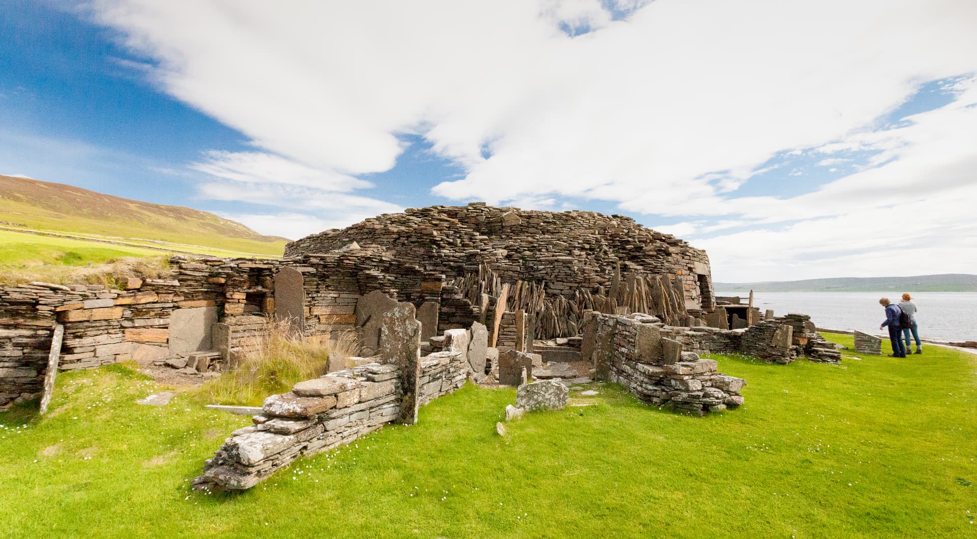
The Brough of Birsay rises from the sea off the northwest coast of Orkney, reachable only when the tide withdraws. For seven centuries, from Pictish monks to Norse earls to medieval pilgrims, this exposed island served as a centre of spiritual and political authority at the northernmost margins of European civilisation. The ruins of a Romanesque church, Norse longhouses, and Pictish carvings share the same wind-scoured ground, layered one upon another like the prayers of successive generations.
Twice each day, the North Atlantic reclaims the Brough of Birsay. The concrete causeway disappears beneath grey water, and the island becomes what it has always been: a place apart. For the hours when crossing is possible, visitors walk the exposed path between rock pools and seaweed to reach twenty-one hectares of windswept grass, ancient stone, and open sky.
What they find is not one sacred site but many, compressed into a single island. The Picts arrived first, sometime in the 7th century, establishing a settlement of sufficient status to produce fine bronze brooches and to carve, on a single stone slab, a processional scene of three robed figures bearing weapons. Whether they built a monastery here or a centre of secular power remains debated. What is certain is that they chose this island, this place separated from the mainland by the rhythm of the tides, as a place worth the effort of habitation.
The Norse came in the early 9th century and did not displace the significance of the place. They amplified it. Over three centuries they built longhouses with under-floor heating, a sauna, barns and workshops. According to the Orkneyinga Saga, Earl Thorfinn the Mighty made Birsay his seat and, around 1048, built a church dedicated to Christ that became the first cathedral of Orkney. Thorfinn had walked to Rome on pilgrimage and returned determined to bring his northern realm into the fold of Christendom.
The Romanesque church that stands in ruin on the Brough today dates to the 12th century. It is small but dignified, with stone benches running along the nave walls and alcoves for altars flanking the chancel entrance. A cloister once adjoined it on the north side. Apart from St Magnus Cathedral in Kirkwall, it is the most sophisticated medieval church building to survive in the Northern Isles.
In 1117, the body of Earl Magnus Erlendsson was brought here after his murder on the island of Egilsay. Miracles were reported at his grave. Pilgrims came. Magnus was canonised in 1135, and around that time his relics were carried to the new cathedral in Kirkwall, following a route that is now walked again as the St Magnus Way. The Brough's role as an ecclesiastical centre faded. The monastery may never have been completed. But the church ruins remain, open to the wind that has shaped this island for longer than anyone has prayed here.
Context and lineage
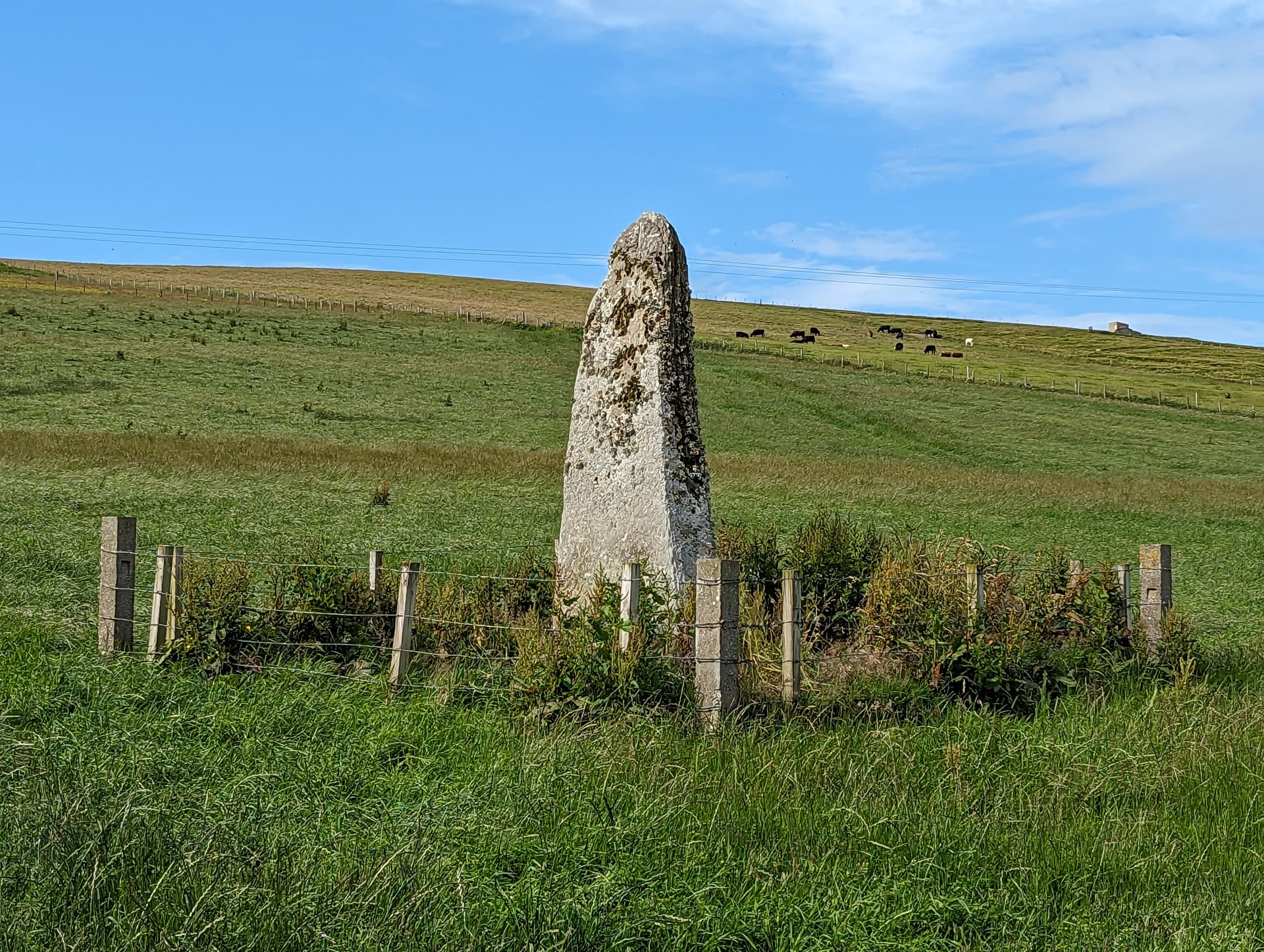
The Picts left no written account of why they chose this tidal island. What survives is the evidence of their presence: traces of buildings, moulds for casting fine bronze brooches and ornaments, and a remarkable carved stone depicting three figures in long robes, processing with spears, swords, and square shields. Four Pictish symbols, the crescent and V-rod, the eagle, the mirror case, and the swimming elephant, complete the composition. This is not the work of a marginal community. The stone speaks of a place of ceremony and authority, established here in the 7th or 8th century on an island that the sea isolates for most of each day.
The Norse arrived in the early 9th century and recognised what the Picts had seen. Over three centuries, they built a substantial settlement that grew and was rebuilt repeatedly, leaving a complex maze of overlapping walls. The Orkneyinga Saga, composed in Iceland around 1200, records that Earl Thorfinn the Mighty held his seat at Birsay. Thorfinn was a figure of considerable ambition. The saga claims he controlled Orkney, the Hebrides, nine Scottish earldoms, and a portion of Ireland. In his later years he made a pilgrimage to Rome and returned to build a minster dedicated to Christ, establishing the first episcopal seat of Orkney around 1048.
The event that transformed Birsay from a centre of political power to a place of pilgrimage occurred on 16 April 1117. On the island of Egilsay, Earl Magnus Erlendsson was murdered on the orders of his cousin and co-ruler, Earl Hakon. Magnus had gone to Egilsay for a meeting that was supposed to resolve their rivalry. Instead, Hakon's cook, Lifolf, struck the fatal blow. Magnus's mother arranged for his body to be carried by ship to Birsay and buried at Christchurch. Soon, miracles were reported at his grave: the sick were healed, lights were seen, fragrance filled the air. Pilgrims came. In 1135, Magnus was canonised, and his feast day was set on 16 April. Around the same time, his relics were translated to the new St Magnus Cathedral in Kirkwall, and Birsay's centrality began to fade.
No continuous monastic or ecclesiastical community survived the site's decline after the 12th century. The connection between the medieval pilgrimage to St Magnus and the modern St Magnus Way, opened in 2017, represents a deliberate revival of a broken tradition. Historic Environment Scotland manages the physical remains. The Orkney Heritage Society and local community maintain awareness of the site's significance.
Earl Thorfinn Sigurdsson (Thorfinn the Mighty)
Earl of Orkney, founder of Christchurch at Birsay
Earl Magnus Erlendsson (St Magnus)
Earl of Orkney, martyr, and patron saint
C.D. Morris
Archaeologist
Why this place is sacred
The thinness of the Brough of Birsay begins before you set foot on the island. It begins with the tide table, with the act of planning around a rhythm that is not your own. The sea decides when you may cross, and when you must leave. There is no negotiation. This submission to natural forces is rare in an age of continuous access, and it alters the quality of attention brought to whatever lies on the other side.
The causeway crossing itself is a passage through a liminal space. The rocks are uneven and sometimes slippery. The sea pools on either side hold small lives, crabs and anemones and kelp, indifferent to your purpose. By the time you reach the island, something has already shifted. The effort of getting there, the awareness that the window will close, creates a presence that most sites must work harder to generate.
Once on the island, the thinness deepens through accumulation. This is not a place where a single event created sanctity. Here, the Picts carved their symbols into stone and cast their bronze. Here, Norse earls built a capital at the edge of the known world. Here, a church was raised in the Romanesque style, its proportions speaking of a connection to European Christendom that seems improbable on this exposed Atlantic rock. Here, a murdered earl was buried, and his grave drew the desperate and the faithful.
Each of these layers would be significant on its own. Together, they create a density of sacred intention that saturates the ground. The wind strips away the inessential. The ruins do not pretend to be more than they are: low walls, open doorways, the ghost of a cloister. But in their honesty, they invite a corresponding honesty from the visitor. There is nowhere to hide from the weather, and nowhere to hide from the questions that a place like this raises about what endures and what the sea eventually takes.
The island sits at the northwestern corner of Orkney, facing nothing but ocean until the coast of Greenland. It is a place at the edge, geographically and psychologically. The Picts and Norse who chose it understood something about margins. Sacred things happen at boundaries, where one world meets another, where land meets sea, where the tide makes and unmakes a path.
The earliest settlement, Pictish in origin, dates to the 7th century and likely served as either a monastic community or a high-status secular centre with religious functions. The Norse repurposed the island as an earldom seat and episcopal centre. Earl Thorfinn's Christchurch, built around 1048, established the site as the first seat of the Bishops of Orkney.
From Pictish settlement to Norse capital to medieval pilgrimage site to scheduled monument. The site's ecclesiastical importance faded after 1135 when St Magnus's relics were translated to Kirkwall. The Brough became uninhabited. In 1925, a Stevenson lighthouse was built on the island. Archaeological excavations, notably by C.D. Morris from the 1970s, revealed the multi-period settlement. The site is now managed by Historic Environment Scotland. In 2017, the St Magnus Way pilgrimage route was opened, passing through Birsay and reconnecting the site to a living tradition of walking and spiritual seeking.
Traditions and practice
The Picts practiced early Christianity alongside their own symbolic traditions, as evidenced by the carved stone and metalwork. The Norse established formal Christian worship through Christchurch and the Romanesque church, with an episcopal seat and monastic community. Medieval pilgrims came to venerate the relics of St Magnus and to seek healing at his grave.
The St Magnus Way, opened on 16 April 2017, the 900th anniversary of Magnus's martyrdom, is a 90-kilometre pilgrimage route through Mainland Orkney. It passes through Birsay, tracing the path along which Magnus's body was carried from Evie to Birsay and later the route his relics took from Birsay toward Kirkwall. Pilgrims can download a companion app that provides historical and spiritual resources at waypoints along the route using bluetooth beacons. The route can be walked in three to five days. Beyond the formal pilgrimage, many visitors come to the Brough for quiet exploration and contemplation.
Let the tide set the terms of your visit. Arrive early enough to consult the tide table without haste. Cross the causeway slowly, noticing the transition from mainland to island. On the Brough, begin at the Norse settlement and move through the ruins without hurrying. Pause at the replica Pictish stone and consider the three figures, who they might have been, where they were going. Enter the Romanesque church and stand within its roofless walls. If the weather permits, sit. Listen to the wind passing through the doorways. Walk to the cliffs at the western end and look out at the Atlantic. Then return, with time to spare, before the sea resumes its ancient work of separation.
Christianity
ActiveThe Brough of Birsay was the seat of the first Bishop of Orkney, established when Earl Thorfinn built Christchurch around 1048 AD. The 12th-century Romanesque church dedicated to St Peter represents one of the finest medieval ecclesiastical buildings in the Northern Isles. After St Magnus was buried here in 1117, the site became a pilgrimage destination. The St Magnus Way, a 90-kilometre pilgrimage route opened in 2017 on the 900th anniversary of Magnus's martyrdom, passes through Birsay and maintains a living connection between this ancient site and contemporary Christian pilgrimage.
Walking the St Magnus Way; contemplative visits to the Romanesque church ruins; pilgrimage on the feast of St Magnus (16 April).
Pictish Spiritual Tradition
HistoricalThe Pictish settlement on the Brough, dating from the 7th century, represents one of the earliest known communities on the island. The Pictish symbol stone, with its processional scene and symbolic carvings, suggests ceremonial practices combining indigenous Pictish traditions with elements of early Christianity. Fine metalwork production indicates a community of high status. The exact nature of Pictish spiritual practice on the Brough cannot be fully reconstructed, but the choice of this tidal island as a site of significance parallels other Pictish monastic foundations on islands and promontories.
Early Christian worship; symbolic stone carving; fine metalwork production.
Experience and perspectives
Begin with the tide. This is not a detail of logistics but the defining quality of the experience. Look up the tide times for Birsay, allow for the fact that the causeway is passable for roughly two hours on either side of low tide, and plan accordingly. The need to coordinate with the sea reframes the visit before it begins.
Drive to the car park at the Point of Buckquoy, at the end of the road beyond Birsay village. From here, the Brough is visible across the strait, a flat-topped island with a lighthouse at its western end and the outline of ruins across its eastern face. When the tide is out, the concrete causeway appears, a narrow path of grey stone stretching across the foreshore. It is uneven and can be slippery with seaweed. Wear sturdy, waterproof boots.
The crossing takes ten to fifteen minutes. There is no rushing it. The pools of seawater on either side demand care with each step. This enforced slowness is a gift, though it may not feel like one when the wind is in your face.
On reaching the island, the ruins spread across the grass in a complex of low walls. The Norse settlement is the first area encountered, a maze of building foundations where individual rooms from the 10th century can be traced. Look for the remains of the sauna, a reminder that these were people who understood comfort even at the edge of the world. Nearby, a replica of the Pictish symbol stone stands among the Norse walls, its three robed figures processing in eternal silence. The original is in the National Museum of Scotland in Edinburgh.
Walk toward the Romanesque church. It is small, its walls standing to waist height or a little above, but its proportions convey an intention beyond mere shelter. Stone benches line the nave walls. Alcoves for altars flank the entrance to the chancel. To the north, the footprint of a monastic cloister can be discerned. Stand within the church and look upward. There is no roof now, only sky. The openness is appropriate. Whatever prayers were offered here have been returning to the air for nine centuries.
If time permits, walk to the western end of the island toward the lighthouse. The cliffs here are dramatic, and seabirds nest in summer. The Atlantic stretches unbroken to the horizon. This is the edge of Europe, and it feels like it.
Keep time. The tide does not wait. Begin your return across the causeway with generous margin. The walk back, with the mainland growing closer, can feel like a return from somewhere further than twenty-one hectares of grass and stone.
The Brough of Birsay lies off the northwest coast of Mainland Orkney, approximately 13 miles north of Stromness. Access is from the car park at the Point of Buckquoy, at the end of the road through Birsay village. The causeway connects the mainland to the island at low tide. The island runs roughly east to west, with the Norse settlement and Romanesque church on the eastern portion and the lighthouse at the western end.
The Brough of Birsay can be understood as an archaeological site of international significance, as a chapter in the story of Norse Christendom, as a pilgrimage destination connected to the cult of St Magnus, or as a meditation on the relationship between isolation and sanctity.
Archaeologists recognise the Brough as one of the most important Norse-period sites in Scotland, with significant Pictish antecedents. C.D. Morris's excavations from the 1970s established a multi-phase chronology revealing Pictish settlement from the 7th century overlaid by Norse construction from the 9th century through to the 12th-century Romanesque church and monastery. The Pictish symbol stone, now in the National Museum of Scotland, is considered one of the most important Pictish carved stones in the Northern Isles, with its unique processional scene and combination of symbols. Scholarly debate continues over whether Earl Thorfinn's Christchurch was located on the Brough or on the mainland where St Magnus Church now stands.
The Orkneyinga Saga, composed in Iceland around 1200, provides the primary narrative framework for understanding the site. It presents Birsay as the seat of the most powerful Norse earl and the birthplace of Orcadian Christianity. The cult of St Magnus, which drew medieval pilgrims to Birsay, represents one of the most significant hagiographic traditions of the Northern Isles. The St Magnus Way, opened in 2017, revives this tradition for contemporary pilgrims.
The tidal nature of the island has attracted attention from those interested in liminal and threshold spaces in sacred geography. The regular submersion and emergence of the causeway mirrors seasonal and ritual cycles of death and rebirth found in many spiritual traditions. Some visitors and writers have noted the island's position at the very edge of the European continent as significant, a place where the boundary between the human and the elemental is worn thin by wind and water.
Whether Thorfinn's Christchurch stood on the Brough or the mainland remains one of Orcadian archaeology's enduring questions. The full nature and extent of the Pictish settlement, and whether it was monastic or secular in character, is unresolved. The identity of the three figures on the Pictish symbol stone, and the meaning of their procession, has never been determined. The reasons successive cultures chose this particular tidal island as a centre of authority and worship, when more accessible locations were available, invite speculation but resist definitive answer.
Visit planning
Limited accommodation in Birsay village. More options in Dounby (6 miles east) and Stromness (13 miles south). Kirkwall, the main town of Orkney, is approximately 20 miles east with a full range of accommodation.
Respect the site as both a scheduled ancient monument and a place of centuries of worship. Check tide times, wear appropriate clothing, leave no trace, and do not disturb the ruins.
Sturdy waterproof boots essential for the causeway crossing. Warm, windproof, and waterproof outer layers. The island is fully exposed to Atlantic conditions regardless of season.
Permitted throughout. The changing light, sea conditions, and dramatic coastal setting offer exceptional photographic opportunities.
Do not leave offerings or objects on the monument. The site is a scheduled monument and disturbance is a legal offence.
Access governed by tides: approximately two hours either side of low tide. The site is a scheduled ancient monument; disturbance, excavation, or metal detecting is prohibited without permission from Historic Environment Scotland.
Plan your visit
Address
Brough of Birsay, Orkney KW17 2LX, UK
Hours, fees, and access can change — verify on the official source before you travel. Practical details last checked Jun 2026.
Nearby sacred places
Sacred places within a half-day’s reach. Pilgrims often visit them together: walk one, stay for the other.


References
Sources consulted when researching this page. Independent verification by readers is welcome.
- 01Brough of Birsay: History - Historic Environment Scotland — Historic Environment Scotlandhigh-reliability
- 02Brough of Birsay - Historic Environment Scotland — Historic Environment Scotlandhigh-reliability
- 03Brough of Birsay, Orkney - University of Glasgow — University of Glasgow School of Humanitieshigh-reliability
- 04Brough of Birsay, Pictish Symbol Stone - trove.scot — National Museums Scotland / trove.scothigh-reliability
- 05Brough of Birsay - Viking Ship Museum — Vikingeskibsmuseet (Viking Ship Museum, Roskilde)high-reliability
- 06Brough of Birsay - VisitScotland — VisitScotlandhigh-reliability
- 07Brough of Birsay - Wikipedia
- 08Brough of Birsay, Orkney - Britain Express — Britain Express
- 09Brough of Birsay - Follow the Vikings — Follow the Vikings / Council of Europe Cultural Route
- 10St Magnus Way - Birsay Viking Capital — St Magnus Way
Key questions
What pilgrims usually ask
- Why is Brough of Birsay considered sacred?
- The Brough of Birsay is a tidal island off Orkney bearing the ruins of a Pictish settlement, Norse longhouses, and a 12th-century Romanesque church linked to th
- What should I wear at Brough of Birsay?
- Sturdy waterproof boots essential for the causeway crossing. Warm, windproof, and waterproof outer layers. The island is fully exposed to Atlantic conditions regardless of season.
- Can I take photos at Brough of Birsay?
- Permitted throughout. The changing light, sea conditions, and dramatic coastal setting offer exceptional photographic opportunities.
- How long should I spend at Brough of Birsay?
- 1-2 hours on the island. Add 20-30 minutes for the causeway crossing each way. A half day allows for exploration of the Brough, the Earl's Palace ruins on the mainland, and St Magnus Church in Birsay village.
- What offerings are appropriate at Brough of Birsay?
- Do not leave offerings or objects on the monument. The site is a scheduled monument and disturbance is a legal offence.
- What etiquette should visitors follow at Brough of Birsay?
- Respect the site as both a scheduled ancient monument and a place of centuries of worship. Check tide times, wear appropriate clothing, leave no trace, and do not disturb the ruins.
- What is the history of Brough of Birsay?
- The Picts left no written account of why they chose this tidal island. What survives is the evidence of their presence: traces of buildings, moulds for casting fine bronze brooches and ornaments, and a remarkable carved stone depicting three figures in long robes, processing with spears, swords, and square shields. Four Pictish symbols, the crescent and V-rod, the eagle, the mirror case, and the swimming elephant, complete the composition. This is not the work of a marginal community. The stone speaks of a place of ceremony and authority, established here in the 7th or 8th century on an island that the sea isolates for most of each day. The Norse arrived in the early 9th century and recognised what the Picts had seen. Over three centuries, they built a substantial settlement that grew and was rebuilt repeatedly, leaving a complex maze of overlapping walls. The Orkneyinga Saga, composed in Iceland around 1200, records that Earl Thorfinn the Mighty held his seat at Birsay. Thorfinn was a figure of considerable ambition. The saga claims he controlled Orkney, the Hebrides, nine Scottish earldoms, and a portion of Ireland. In his later years he made a pilgrimage to Rome and returned to build a minster dedicated to Christ, establishing the first episcopal seat of Orkney around 1048. The event that transformed Birsay from a centre of political power to a place of pilgrimage occurred on 16 April 1117. On the island of Egilsay, Earl Magnus Erlendsson was murdered on the orders of his cousin and co-ruler, Earl Hakon. Magnus had gone to Egilsay for a meeting that was supposed to resolve their rivalry. Instead, Hakon's cook, Lifolf, struck the fatal blow. Magnus's mother arranged for his body to be carried by ship to Birsay and buried at Christchurch. Soon, miracles were reported at his grave: the sick were healed, lights were seen, fragrance filled the air. Pilgrims came. In 1135, Magnus was canonised, and his feast day was set on 16 April. Around the same time, his relics were translated to the new St Magnus Cathedral in Kirkwall, and Birsay's centrality began to fade.
- Who is associated with Brough of Birsay?
- Earl Thorfinn Sigurdsson (Thorfinn the Mighty) (Earl of Orkney, founder of Christchurch at Birsay), Earl Magnus Erlendsson (St Magnus) (Earl of Orkney, martyr, and patron saint), C.D. Morris (Archaeologist)