Skara Brae Prehistoric Village
A Neolithic village older than Stonehenge, preserved beneath Orkney sand for four thousand years
Sandwick, Orkney Islands, United Kingdom
Plan this visit
Practical context before you go
1 hour minimum for the village, replica house, and visitor centre. 1.5-2 hours recommended, including Skaill House and the coastal walk. A full day allows exploration of all Heart of Neolithic Orkney sites.
Respect Skara Brae as both a heritage site and a place of ancient habitation and burial. Observe from the walkways. Leave no trace. Dress for Orkney weather.
At a glance
- Coordinates
- 59.0488, -3.3418
- Type
- Prehistoric Village
- Suggested duration
- 1 hour minimum for the village, replica house, and visitor centre. 1.5-2 hours recommended, including Skaill House and the coastal walk. A full day allows exploration of all Heart of Neolithic Orkney sites.
Pilgrim tips
- Orkney weather is unpredictable at all times of year. Waterproof outer layers, warm clothing, and wind protection are essential. The site is fully exposed to Atlantic winds. Sturdy footwear is recommended.
- Photography is permitted throughout the site. The houses photograph well from the raised walkways, and the Bay of Skaill provides a dramatic backdrop. Low-angle light in morning or evening reveals the depth and texture of the stone interiors.
- The original houses cannot be entered; they are viewed from raised walkways. Do not lean on or touch the ancient stonework. The site is exposed to Atlantic weather and conditions can change rapidly.
Overview
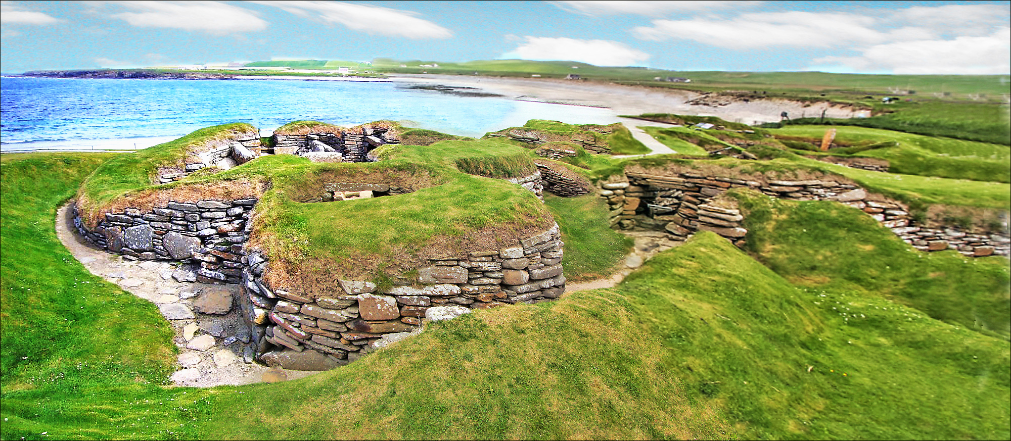
On the western shore of Orkney's Mainland, the Bay of Skaill opens to the Atlantic. Beside it, half-buried in the grass, lie the remains of a village that was already ancient when the Pyramids were new. Skara Brae was home to a farming and fishing community from roughly 3180 to 2500 BC. Buried by sand, forgotten for four millennia, and torn open again by a storm in 1850, it survives as the most complete Neolithic settlement in Western Europe. The stone furniture still stands inside the houses: beds, dressers, hearths, storage cells. No other site brings the domestic reality of the deep past so close.
There are places where the distance between the present and the deep past narrows to almost nothing. Skara Brae is one of them. On the western coast of Orkney's Mainland, where the Atlantic meets the Bay of Skaill, ten stone houses lie clustered together, connected by covered passages, sunk into mounds of their own accumulated refuse. They were built more than five thousand years ago and abandoned around 2500 BC, roughly when the first stones were being raised at Stonehenge. Sand covered the village. Time passed. Four thousand years passed.
Then, in the winter of 1850, a great storm ripped the grass from a high dune and exposed what lay beneath: the outlines of rooms, the shapes of furniture, the remains of a community frozen in the moment of its departure. The excavations that followed, first by the local laird William Watt and then definitively by the archaeologist V. Gordon Childe between 1928 and 1930, revealed something without parallel in northern Europe. Not ruins. Not foundations. Rooms. Stone dressers still standing against the walls. Box beds framed in stone, the right-hand bed always larger than the left. Central hearths squared off with upright stones. Storage cells built into the thick walls. A drainage system running beneath the village.
This is not a monument built to impress. It is something more unsettling and more moving: a record of daily life. The people who lived here raised cattle and sheep, grew barley, fished the surrounding waters, and crafted tools from stone, bone, and whale ivory. They made Grooved Ware pottery, a distinctive style that would spread across the British Isles. They produced beads, pins, and pendants. They carved mysterious stone balls whose purpose no one has deciphered. They buried two women beneath the floor of House 7 before the house was built, a foundation deposit whose meaning remains opaque.
Skara Brae belongs to the Heart of Neolithic Orkney, a UNESCO World Heritage Site that includes the Ring of Brodgar, the Stones of Stenness, and the great chambered cairn of Maes Howe. Together these sites reveal an island culture of extraordinary sophistication, a society that built communal monuments on a scale that implies organised labour, shared belief, and long-term vision. Skara Brae is the domestic counterpart to those ceremonial centres, the place where the people who raised the stones came home to sleep.
Context and lineage
The origins of Skara Brae lie in the Neolithic communities that settled Orkney's Mainland around 3180 BC. They chose a site beside the Bay of Skaill, protected from the worst of the Atlantic weather by the surrounding landscape. Over the centuries that followed, they built and rebuilt their homes, sinking them into the earth and insulating them with layers of domestic refuse. The village grew to perhaps ten houses, interconnected by covered stone passages, housing a community of fifty to one hundred people.
They were farmers who grew barley and raised cattle, sheep, and pigs. They were fishers who took what the sea offered. They were craftspeople of considerable skill, producing Grooved Ware pottery with its distinctive incised patterns, working bone and whale ivory into pins and beads, and carving stone balls whose purpose has eluded every attempt at explanation.
Their homes followed a shared design so consistent that it must have carried cultural significance. Every house placed its hearth at the centre, its dresser facing the door, its larger bed to the right. Whether this standardisation reflected practical wisdom, social convention, or cosmological orientation, or all three at once, remains one of the village's many unanswered questions.
Around 2500 BC, the community departed. The climate was shifting, growing colder and wetter. Sand was advancing over the land. Whether they left gradually or in haste is debated, but they left, and the sand that may have driven them away also sealed their homes against the passage of time. Four thousand years later, a winter storm peeled back the covering and revealed what lay beneath.
No continuous cultural tradition connects the Neolithic inhabitants of Skara Brae to any living community. The village was forgotten for four thousand years. Its significance is now understood through archaeological investigation, heritage management by Historic Environment Scotland, and interpretation for visitors through the on-site visitor centre and Orkney's network of heritage sites.
William Watt
First excavator
V. Gordon Childe
Principal archaeologist
David Clarke
Later excavator
Why this place is sacred
The quality that distinguishes Skara Brae from other ancient sites is domestic recognition. Most prehistoric monuments communicate through scale or geometry or alignment with celestial events. Skara Brae communicates through beds and dressers and hearths. The furniture is still there. The beds are box-shaped enclosures of stone, and the right-hand bed is larger than the left in every house, a convention whose meaning is lost but whose consistency speaks of shared understanding. The dresser faces the entrance in every house, the first thing seen upon entering, suggesting it held objects of importance, display, or perhaps reverence.
This is what collapses the distance. Not the age of the site, though that is staggering. Not the archaeological significance, though that is immense. What reaches through five millennia is the arrangement of a room. Someone decided where the hearth should go. Someone chose which bed would be larger. Someone placed objects on a dresser where they could be seen. These are recognisable human acts, and their recognition creates a form of communion that no inscription or carving could achieve.
Beneath the floor of House 7, the oldest and most enigmatic structure in the village, two women were buried before the house was built above them. Archaeologists call this a foundation deposit. Whatever name we give it, the act speaks of a relationship between the living and the dead that was built into the structure of daily life. The dead were not sent away. They were placed beneath the floor where the living would walk, eat, and sleep above them.
The village was connected by covered passages, sheltered from the relentless Orkney wind. The walls were insulated with midden material packed between inner and outer stone skins. These were not primitive shelters but considered responses to a demanding environment, engineered with skill and maintained with care. The drainage system that ran beneath the houses included what appear to be rudimentary toilets. The people of Skara Brae managed waste, insulated against cold, and designed their homes for comfort. Five thousand years later, these remain recognisable priorities.
And then they left. Around 2500 BC, the village was abandoned. The old story tells of a sudden flight, a woman dropping her necklace of beads as she squeezed through the narrow door of House 7 during a catastrophic sandstorm. Modern archaeology favours a more gradual departure, perhaps over twenty to thirty years, as the climate cooled and sand encroached on the land. Either way, the sand that drove them out also preserved what they left behind, sealing the village in a kind of accidental time capsule until the storm of 1850 broke it open again.
A permanent farming and fishing settlement housing a community of perhaps fifty to one hundred people over a period of approximately seven hundred years, from 3180 to 2500 BC. The village served as both domestic habitation and a point of connection to the wider ceremonial landscape of Neolithic Orkney.
After abandonment around 2500 BC, the village was buried by windblown sand and remained hidden for approximately four thousand years. The storm of 1850 exposed the ruins. William Watt excavated four houses in the 1860s. V. Gordon Childe conducted the major excavation from 1928 to 1930, initially dating the site to the Iron Age before radiocarbon dating established its Neolithic origins. David Clarke's excavations in the 1970s refined understanding further. The site became part of the Heart of Neolithic Orkney UNESCO World Heritage Site in 1999. Today it is managed by Historic Environment Scotland with a visitor centre, replica house, and staffed interpretation.
Traditions and practice
The Neolithic inhabitants of Skara Brae lived in a way that blurred any boundary between the domestic and the ritual. The foundation burial of two women beneath House 7 placed the dead at the base of the living space. The stone dresser, positioned to face every entrance, may have served as an altar or a display for objects of communal significance as much as practical storage. The carved stone balls found at the site, beautifully worked objects with no obvious functional purpose, hint at ceremonial or symbolic dimensions of daily life. The uniformity of the house design suggests conventions that went beyond the practical. The proximity of the village to the great ceremonial centres of Brodgar and Stenness indicates that the inhabitants participated in the wider ritual life of Neolithic Orkney.
Visitors approach the site through the visitor centre, walk the raised paths between the houses, enter the full-scale replica, and explore the adjacent Skaill House. Many visit Skara Brae as part of a wider engagement with the Heart of Neolithic Orkney, travelling between the village, the Ring of Brodgar, the Stones of Stenness, and Maes Howe in the course of a day.
Give the visitor centre your full attention before approaching the village. Let the artefacts establish the scale of human ingenuity before you see the architecture. At the village, slow down. Look into each house individually rather than walking past them as a sequence. Notice the dresser in each one. Notice the beds. Let the recognition settle: this was someone's home. At the replica house, step inside and stay long enough for the proportions to work on you. Afterward, walk the beach below the site and look back at the settlement from the shore, as the Neolithic inhabitants would have seen it returning from their boats.
Neolithic Domestic and Communal Life
HistoricalSkara Brae preserves the most complete evidence of Neolithic daily life anywhere in Western Europe. The community that lived here from approximately 3180 to 2500 BC maintained a sophisticated domestic culture characterised by standardised architecture, skilled craftsmanship, and communal organisation. Their Grooved Ware pottery tradition spread across the British Isles, suggesting Orkney's role as a centre of cultural influence rather than a remote periphery.
Farming of barley and husbandry of cattle, sheep, and pigs. Fishing and gathering of marine resources. Production of Grooved Ware pottery, bone and stone tools, beads, pins, and carved stone balls. Communal living in interconnected houses with shared architectural conventions. Foundation burials and possible ritual use of House 7 and Structure 8.
Experience and perspectives
The approach to Skara Brae passes through the visitor centre, where artefacts recovered from the excavations are displayed: Grooved Ware pottery, bone pins, stone tools, and the enigmatic carved stone balls. Take time here. The objects are small and human-scaled. They fit in the hand. They were made by the same people whose homes you are about to see.
The path leads out along the coast toward the Bay of Skaill. The landscape is treeless, wind-scoured, the grass pressed flat by the Atlantic. This is Orkney, and the weather is part of the experience. The Neolithic inhabitants of Skara Brae lived with this wind every day of their lives, and the design of their homes, sunk into the earth, insulated with midden, connected by covered passages, was a direct response to it.
The village appears as a cluster of stone walls emerging from the green turf, the roofs long gone. Raised walkways allow you to look down into the houses. And here is where the experience shifts. You are not looking at walls. You are looking into rooms. The stone dresser stands against the far wall, its shelves intact. The box beds project from the side walls. The hearth occupies the centre. Storage cells are tucked into the thickness of the walls. The proportions are domestic, human, immediate.
Pause at House 7. It stands apart from the others, the oldest structure, the one with wall carvings and a door that could be locked. Beneath its floor lie the remains of two women, buried before the house was built. What relationship between the living and the dead does this foundation deposit express? The question has no certain answer, but the act of asking it, of standing above the buried dead while looking at the room where people cooked and slept, brings the ritual dimensions of Neolithic domestic life into focus.
The replica house, built to full scale, allows you to step inside and feel the proportions from within. The ceiling is low. The light is dim. The hearth is at your feet, the dresser before you, the beds to either side. For a moment, the five thousand years contract to nothing, and you are simply in someone's home.
Afterward, walk along the beach below the site. The sand that buried and preserved Skara Brae stretches along the bay. The sea that threatens the site today is the same sea the inhabitants fished. The same Atlantic weather that eroded the dunes in 1850 once drove a community to shelter in the earth. There is something circular in this, a reminder that even the most enduring human constructions exist at the pleasure of the elements.
Skara Brae is located on the west coast of Mainland Orkney, beside the Bay of Skaill. The site is accessed via the B9056 from the A967. A free car park serves the site. The visitor centre is the starting point, with the path leading to the village and then to Skaill House. The Heart of Neolithic Orkney's other sites, the Ring of Brodgar, Stones of Stenness, and Maes Howe, lie approximately 6-8 miles to the east.
Skara Brae can be understood as an archaeological monument of the highest importance, as a window into Neolithic domestic life, as evidence of a society in which the sacred and the everyday were interwoven, or as a meditation on what endures and what is lost across the vast reaches of human time.
Archaeologists recognise Skara Brae as the most complete Neolithic settlement in Western Europe. The standardised house design, Grooved Ware pottery tradition, and communal layout indicate a structured society with shared cultural norms. Radiocarbon dating has established occupation from approximately 3180 to 2500 BC. The village was part of a wider Neolithic cultural landscape in Orkney that included major ceremonial centres at Brodgar, Stenness, and the recently discovered Ness of Brodgar complex. Research by the Ness of Brodgar project has placed Skara Brae within a broader understanding of Neolithic Orkney as a centre of cultural innovation and long-distance influence, evidenced by the spread of Grooved Ware pottery across the British Isles. The gradual abandonment of the village around 2500 BC is now attributed to environmental change rather than sudden catastrophe.
No continuous oral or cultural tradition connects the Neolithic inhabitants of Skara Brae to any living community. The village was buried and forgotten for approximately four thousand years before its rediscovery. Orkney's later inhabitants, the Picts, Norse settlers, and Scots, left no recorded knowledge of the site's existence.
Contemporary spiritual practitioners sometimes interpret Orkney as a major energy landscape, with the Heart of Neolithic Orkney sites forming a connected sacred geography. The carved stone balls are occasionally associated with theories about sacred geometry. The foundation burials beneath House 7 attract speculation about ancestor worship and the spiritual consecration of domestic space. The village's four-thousand-year burial and subsequent revelation by storm has metaphorical resonance for those interested in the uncovering of hidden knowledge.
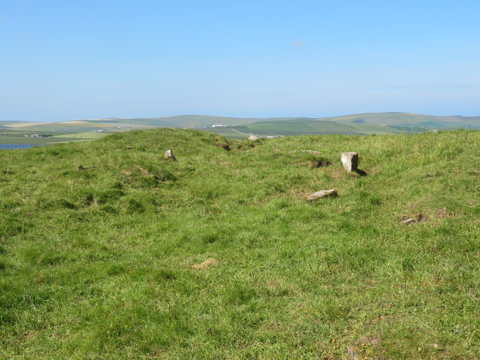
The purpose of the carved stone balls remains entirely unexplained. The reason the right-hand bed was consistently larger than the left in every house has no confirmed interpretation. The significance of the foundation burials beneath House 7 is debated. The exact nature of House 7's special status, given its separate location, lockable door, and wall carvings, is unclear. How many more structures were lost to coastal erosion before the 1850 discovery is unknown. The specific beliefs, rituals, and cosmology of the inhabitants cannot be recovered from the material record alone.
Visit planning
Accommodation in Stromness (7 miles) and Kirkwall (15 miles), Orkney's two towns. B&Bs, hotels, self-catering cottages, and camping across Mainland Orkney. The Standing Stones Hotel near the Ring of Brodgar provides a base within the World Heritage landscape.
Respect Skara Brae as both a heritage site and a place of ancient habitation and burial. Observe from the walkways. Leave no trace. Dress for Orkney weather.
Orkney weather is unpredictable at all times of year. Waterproof outer layers, warm clothing, and wind protection are essential. The site is fully exposed to Atlantic winds. Sturdy footwear is recommended.
Photography is permitted throughout the site. The houses photograph well from the raised walkways, and the Bay of Skaill provides a dramatic backdrop. Low-angle light in morning or evening reveals the depth and texture of the stone interiors.
Not appropriate. Skara Brae is a managed heritage site. Do not leave objects, coins, or offerings in or around the houses.
Visitors cannot enter the original houses. Dogs on leads are permitted in the grounds but not in the visitor centre. Online booking is recommended, especially during summer months when cruise ships bring large numbers of visitors.
Plan your visit
Address
Sandwick, Stromness KW16 3LR, UK
Phone
Hours
Hours, fees, and access can change — verify on the official source before you travel. Practical details last checked Jun 2026.
Nearby sacred places
Sacred places within a half-day’s reach. Pilgrims often visit them together: walk one, stay for the other.


References
Sources consulted when researching this page. Independent verification by readers is welcome.
- 01Skara Brae - World History Encyclopediahigh-reliability
- 02Historic Environment Scotland - Skara Brae Overviewhigh-reliability
- 03Historic Environment Scotland - Skara Brae History and Researchhigh-reliability
- 04Heart of Neolithic Orkney - UNESCO World Heritage Centrehigh-reliability
- 05Historic Environment Scotland - Skara Brae Prices and Timeshigh-reliability
- 06Skara Brae - Wikipedia
- 07Stepping Back in Time at Skara Brae - Ancient Origins
- 08Skara Brae - Orkneyology
- 09A Pilgrimage To Orkney - John Beckett (Patheos)
- 10Pilgrimage to Scotland: Orkney's Neolithic Ring of Brodgar and Skara Brae - Susan Beilby Magee
Key questions
What pilgrims usually ask
- Why is Skara Brae Prehistoric Village considered sacred?
- Skara Brae is Western Europe's most complete Neolithic village, older than Stonehenge and the Pyramids. Preserved under Orkney sand for 4,000 years, its stone f
- What should I wear at Skara Brae Prehistoric Village?
- Orkney weather is unpredictable at all times of year. Waterproof outer layers, warm clothing, and wind protection are essential. The site is fully exposed to Atlantic winds. Sturdy footwear is recommended.
- Can I take photos at Skara Brae Prehistoric Village?
- Photography is permitted throughout the site. The houses photograph well from the raised walkways, and the Bay of Skaill provides a dramatic backdrop. Low-angle light in morning or evening reveals the depth and texture of the stone interiors.
- How long should I spend at Skara Brae Prehistoric Village?
- 1 hour minimum for the village, replica house, and visitor centre. 1.5-2 hours recommended, including Skaill House and the coastal walk. A full day allows exploration of all Heart of Neolithic Orkney sites.
- What offerings are appropriate at Skara Brae Prehistoric Village?
- Not appropriate. Skara Brae is a managed heritage site. Do not leave objects, coins, or offerings in or around the houses.
- What etiquette should visitors follow at Skara Brae Prehistoric Village?
- Respect Skara Brae as both a heritage site and a place of ancient habitation and burial. Observe from the walkways. Leave no trace. Dress for Orkney weather.
- What is the history of Skara Brae Prehistoric Village?
- The origins of Skara Brae lie in the Neolithic communities that settled Orkney's Mainland around 3180 BC. They chose a site beside the Bay of Skaill, protected from the worst of the Atlantic weather by the surrounding landscape. Over the centuries that followed, they built and rebuilt their homes, sinking them into the earth and insulating them with layers of domestic refuse. The village grew to perhaps ten houses, interconnected by covered stone passages, housing a community of fifty to one hundred people. They were farmers who grew barley and raised cattle, sheep, and pigs. They were fishers who took what the sea offered. They were craftspeople of considerable skill, producing Grooved Ware pottery with its distinctive incised patterns, working bone and whale ivory into pins and beads, and carving stone balls whose purpose has eluded every attempt at explanation. Their homes followed a shared design so consistent that it must have carried cultural significance. Every house placed its hearth at the centre, its dresser facing the door, its larger bed to the right. Whether this standardisation reflected practical wisdom, social convention, or cosmological orientation, or all three at once, remains one of the village's many unanswered questions. Around 2500 BC, the community departed. The climate was shifting, growing colder and wetter. Sand was advancing over the land. Whether they left gradually or in haste is debated, but they left, and the sand that may have driven them away also sealed their homes against the passage of time. Four thousand years later, a winter storm peeled back the covering and revealed what lay beneath.
- Who is associated with Skara Brae Prehistoric Village?
- William Watt (First excavator), V. Gordon Childe (Principal archaeologist), David Clarke (Later excavator)