Ballymeanoch Neolithic site, Kilmartin Glen
Cup-marked stones and a vanished henge in Scotland's densest prehistoric ritual valley
Kilmartin, Alba / Scotland, United Kingdom
Plan this visit
Practical context before you go
Thirty minutes to one hour for Ballymeanoch alone. A full day allows a thorough walk of the wider Kilmartin Glen sacred landscape, following the Kilmartin Museum's self-guided trail to Temple Wood, Nether Largie cairns and standing stones, and Dunadd hillfort.
Free open access at all times, year-round. The site lies approximately 450 metres northwest of Ballymeanoch farm, accessed via a path from the A816 between Lochgilphead and Kilmartin. Limited roadside parking nearby. The terrain is uneven, on a gravel terrace, and often boggy; sturdy waterproof footwear is essential. The site is not wheelchair accessible.
Ballymeanoch is a scheduled monument requiring respect for both archaeological preservation and the deep time it represents. No active worship takes place. Visitors may walk freely among the stones and touch them gently. Photography is welcomed. Leave no trace and disturb nothing.
At a glance
- Coordinates
- 56.1227, -5.4860
- Type
- Standing Stones
- Suggested duration
- Thirty minutes to one hour for Ballymeanoch alone. A full day allows a thorough walk of the wider Kilmartin Glen sacred landscape, following the Kilmartin Museum's self-guided trail to Temple Wood, Nether Largie cairns and standing stones, and Dunadd hillfort.
- Access
- Free open access at all times, year-round. The site lies approximately 450 metres northwest of Ballymeanoch farm, accessed via a path from the A816 between Lochgilphead and Kilmartin. Limited roadside parking nearby. The terrain is uneven, on a gravel terrace, and often boggy; sturdy waterproof footwear is essential. The site is not wheelchair accessible.
Pilgrim tips
- No dress code applies. Practical outdoor clothing is essential for the terrain and weather: waterproof boots above all, as the ground can be thoroughly boggy. Layers accommodate Scotland's changeable conditions, where sun, rain, and wind can arrive within the same hour.
- Photography is freely permitted and encouraged. Low-angle light at dawn or dusk reveals cup marks most effectively. A torch or phone light angled across the stone surface can also illuminate carvings in flat light conditions. Be aware that others may be seeking contemplative space.
- Respect the archaeological integrity of the site. Do not disturb stones, attempt excavation, or scratch surfaces. The ground can be heavily waterlogged; appropriate footwear prevents both personal discomfort and damage to fragile environments. If leaving offerings, ensure they are natural, biodegradable, and unobtrusive. Consider whether leaving anything is appropriate at a site not historically associated with such practices. The scheduled monument designation means that damaging the site is a criminal offence.
Overview
In Kilmartin Glen, where more than 350 ancient monuments cluster within six miles of a quiet village, Ballymeanoch holds its ground with particular intensity. Two rows of standing stones bear cup and ring marks carved perhaps a thousand years before the stones themselves were raised. A henge, now almost invisible beneath centuries of ploughing, once enclosed ceremonies whose nature remains unknown. A kerb cairn held the dead. And a holed stone, toppled in 1943 and since relocated, once served as a threshold for betrothals and healing rites that persisted into living memory. The site spans two millennia of continuous sacred use, and the meaning of its carvings remains one of British archaeology's great unsolved puzzles.
Five thousand years of human intention rest in this quiet corner of Kilmartin Glen. The standing stones of Ballymeanoch rise from boggy grassland on a gravel terrace, their weathered surfaces marked with cup and ring carvings that predate the monuments by centuries. These marks are not later additions but inheritances: the Neolithic and Bronze Age builders chose stones already inscribed with symbols whose meaning may have been ancient even to them, incorporating them into new configurations of meaning.
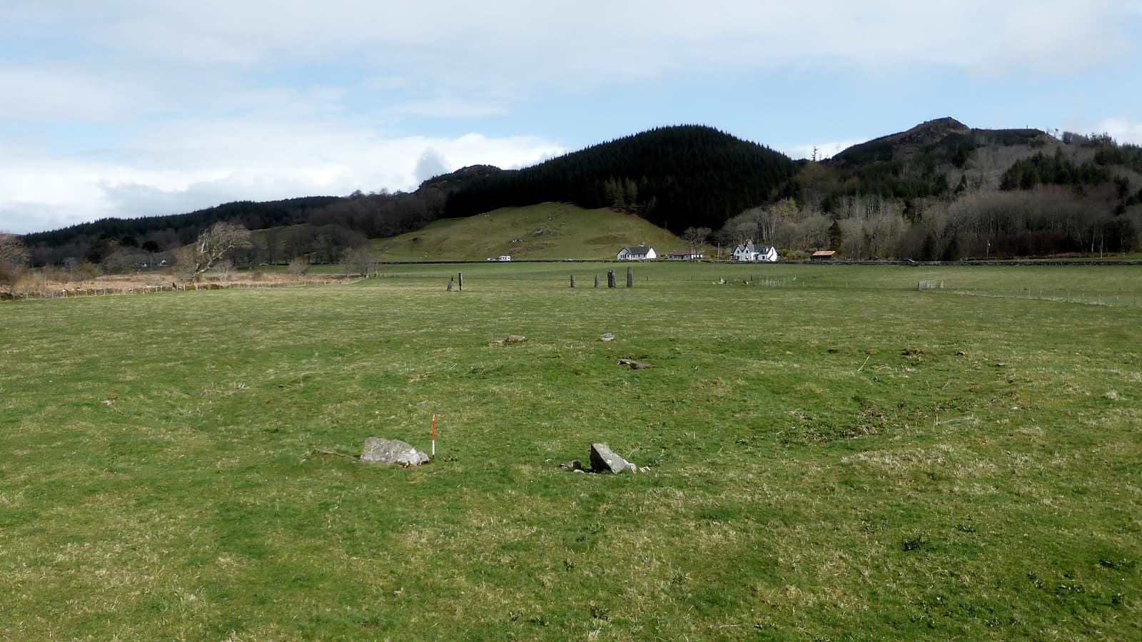
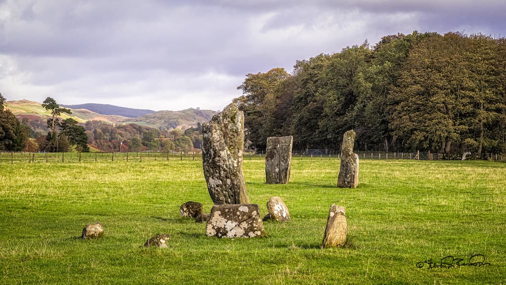
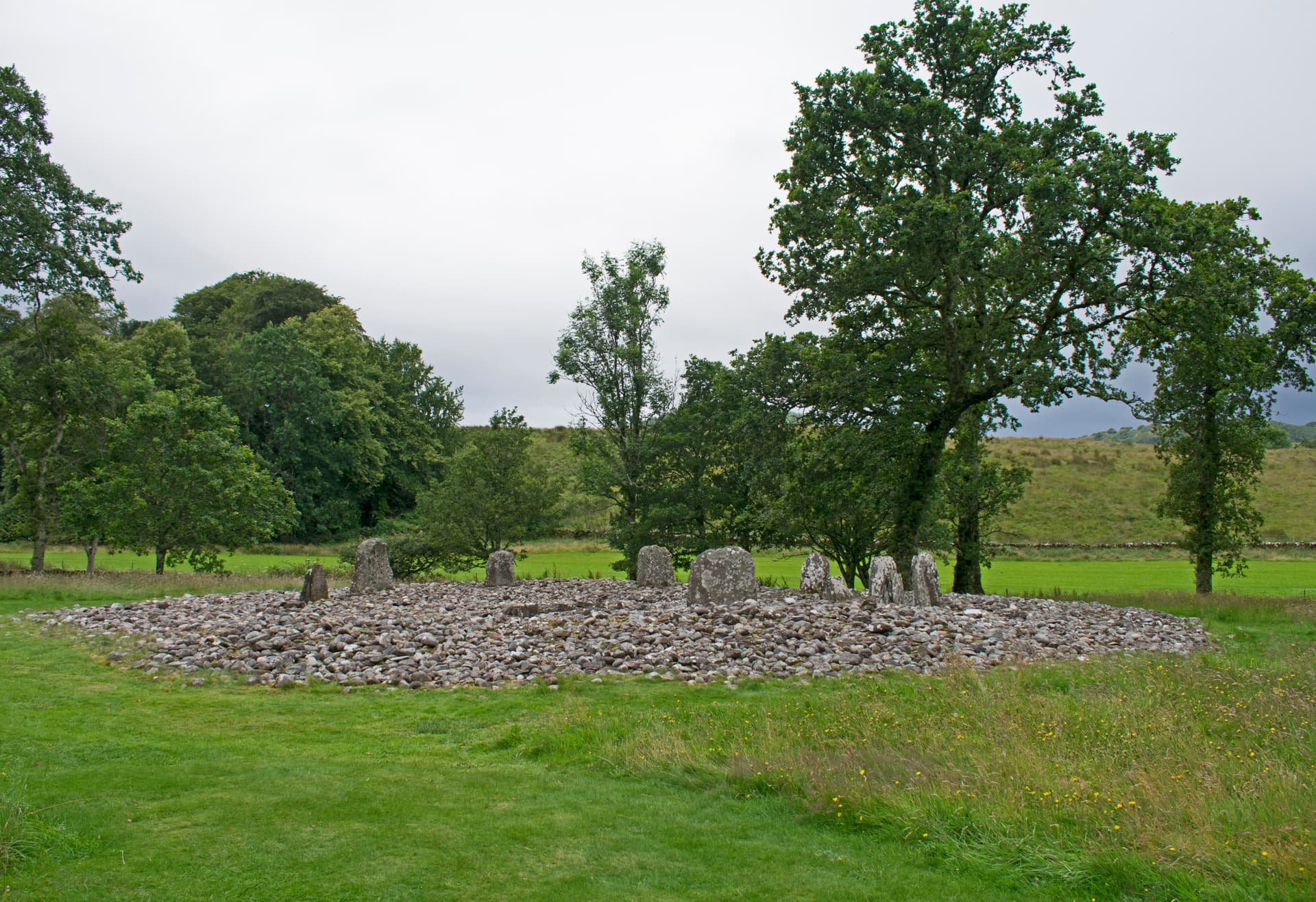
Six stones survive in two rows aligned roughly north-south, the tallest reaching four metres above the ground. The two middle stones of the longer row carry the densest concentration of rock art: the largest bears over seventy cup marks and more than a dozen cup-and-ring marks, some connected by gutters carved between the cup and its surrounding ring. These spiralling depressions appear across Atlantic Europe, from Galicia to Scotland, always recognisable yet never identical. No one knows what they mean. This is not a gap waiting to be filled by future research but a genuine boundary of human understanding.
Approximately 130 metres south of the standing stones, the remains of a henge monument survive as faint undulations in the turf. This was once a Class 2 henge, its ditch 115 feet in diameter and 7 to 12 feet wide, with causeways at east and west permitting processional entry. Canon William Greenwell excavated the interior in 1864, uncovering two cist burials containing a beaker and the teeth of three individuals. The beaker now resides in the British Museum, far from the place where hands shaped it and mouths drank from it.
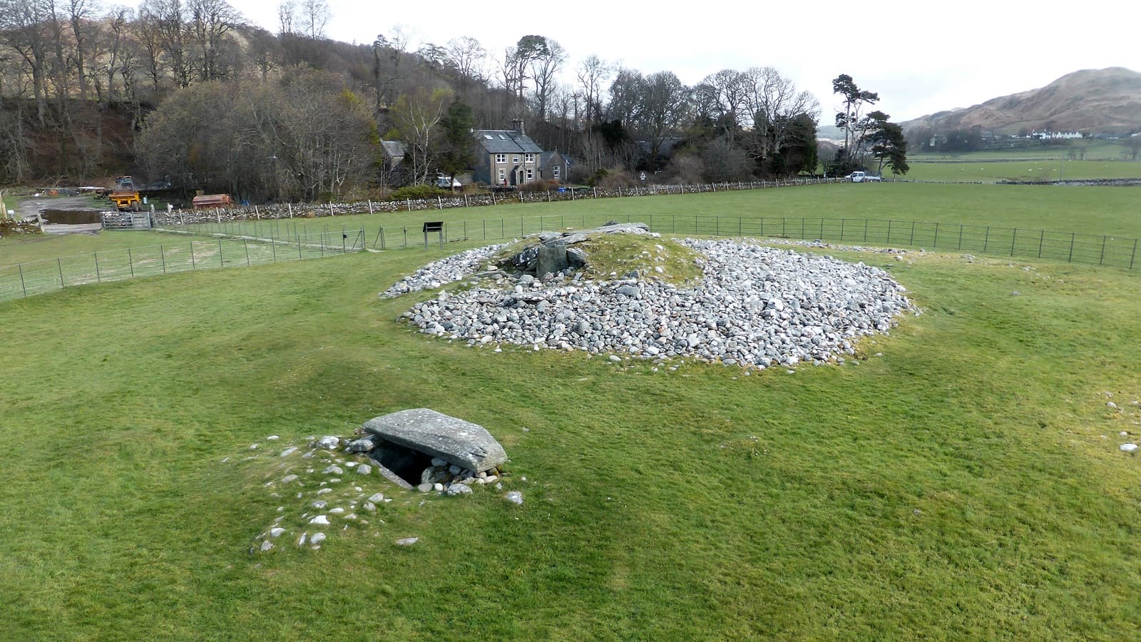
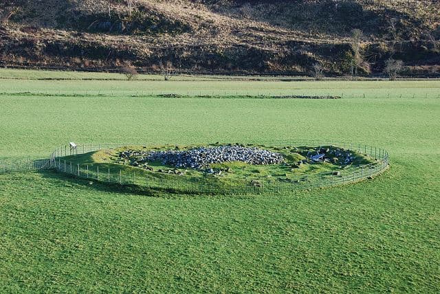
To the northeast of the standing stones sits a kerb cairn: roughly ten slabs set upright in a circle around a mound of cobblestones, built between 1400 and 1200 BCE. Beside it lies the relocated holed stone, once upright, through which couples clasped hands to seal betrothals and mothers passed ailing infants to restore them to health. The stone fell during a storm in 1943, possibly when a Shetland pony leaned against it for shelter. It was excavated in 1977 and placed near the cairn.
Ballymeanoch sits within a landscape so densely inscribed with prehistoric monuments that walking here feels like moving through a text whose grammar has been forgotten. Temple Wood, Nether Largie, Dunadd: the glen holds one of Scotland's greatest concentrations of Neolithic and Bronze Age sites. A 1993 geophysical survey suggested that the visible standing stones are remnants of a larger monument, possibly a processional avenue extending beyond the surviving rows. What remains is the physical evidence of profound devotion and the persistent sense that something of great consequence happened here, repeatedly, across millennia.
Context and lineage
No origin narratives survive from the prehistoric builders of Ballymeanoch. The Gaelic name, Baile Meadhonach, means 'middle settlement' and refers to the location's position between neighbouring townships rather than any legendary significance. What survives instead is the physical evidence of devotion: stones carefully selected for the sacred marks already upon them, laboriously erected into alignments whose purpose escapes recovery, surrounded by a ditch and bank that enclosed ceremony, and marked by burials that honoured the dead. The absence of myth is itself telling. These were people who left their mark in stone rather than in words, and the stone endures where words would have been lost.
Ballymeanoch's lineage spans from anonymous prehistoric builders through centuries of folk practice to contemporary heritage stewardship. The Neolithic and Bronze Age communities who created the site left no names, no written beliefs, only stones and carvings. Later Gaelic speakers named the location but apparently developed no elaborate mythology around it. Folk practices at the holed stone persisted for centuries: betrothals sealed by clasping hands through the aperture, sick infants passed through to restore them to health, business agreements made binding by the stone's authority. Travelling families who camped near Ballymeanoch regarded the standing stones as protective, though tradition held they should not be touched. After the holed stone fell in 1943, it was excavated and relocated in 1977. A 1993 geophysical survey revealed the possible extent of a larger original monument. Today Historic Environment Scotland manages the site as a scheduled monument, while visitors from archaeological, contemplative, and spiritual traditions continue to find meaning among the stones.
Unknown Neolithic and Bronze Age peoples
Canon William Greenwell
Why this place is sacred
Several factors converge to make Ballymeanoch a place where the ordinary sense of time falters. The sheer depth of the site creates vertical resonance: cup marks carved around 3500 BCE, standing stones raised around 2000 BCE, a henge built during the Early Bronze Age, a kerb cairn constructed around 1300 BCE. This is not a single moment frozen in stone but a conversation across generations, each era adding to and reinterpreting what came before.
The mystery of the cup and ring marks intensifies this quality. Unlike many aspects of prehistory where educated guesses feel reasonable, these carvings resist interpretation with unusual stubbornness. They appear across Atlantic Europe in consistent forms, from the coasts of Galicia through Brittany to Ireland and Scotland. They were clearly significant to those who made them. They remain genuinely inscrutable. Standing before a stone covered in these spiralling depressions, each one pecked into the surface with tools of stone or antler by hands dead for five millennia, visitors confront what cannot be known. The carved surface is right there, tangible beneath the fingertips, yet its meaning is utterly unreachable.
The holed stone adds another dimension. Across cultures and ages, apertures in stone have served as thresholds: for healing, for vows, for passage between conditions. At Ballymeanoch, folk memory preserved the practice of passing babies through the hole to cure disease, of lovers clasping hands through the aperture to seal betrothals. Though the stone now lies on its side beside the kerb cairn, the worn smoothness of the aperture testifies to centuries of hands.
The surrounding landscape amplifies every monument. Ballymeanoch does not stand alone. It participates in a sacred geography that includes Temple Wood's stone circles, the Nether Largie burial cairns, the ceremonial fort of Dunadd where early Scottish kings were inaugurated. To walk through Kilmartin Glen is to traverse a landscape that once mattered enormously to its inhabitants for reasons that reach beyond what any single site can explain.
The original purpose of Ballymeanoch remains uncertain. Archaeological evidence establishes that the site functioned as part of a major ceremonial complex spanning Kilmartin Glen. The stone rows may have aligned with astronomical events, though precise calculations remain incomplete. The henge, with its east-west causeways, indicates enclosed ceremonial activity requiring controlled entry and exit. The incorporation of cup-marked stones into the monument suggests continuity of sacred significance across the transition from Neolithic to Bronze Age practices. Whether the site served ancestor veneration, seasonal ceremonies, astronomical observation, or purposes contemporary minds cannot imagine, the generations of labour invested confirm profound importance to its builders.
Ballymeanoch evolved across at least two millennia. The cup and ring marks appear to date from the fourth millennium BCE, carved into natural rock outcrops. Around 2000 BCE, some of these marked stones were quarried and erected as standing stones, incorporating ancient symbols into new configurations. The henge dates to the Early Bronze Age, its 115-foot diameter ditch enclosing a cairn with cist burials. The kerb cairn, built around 1400-1200 BCE, indicates the site continued as a place for honouring the dead. Folk practices at the holed stone persisted into recorded history, with betrothals and healing rituals documented into the modern era. The stone fell in 1943, was excavated in 1977, and now lies beside the cairn it once overlooked. A 1993 geophysical survey revealed traces of a possible larger monument, suggesting the story of Ballymeanoch extends beyond what is visible.
Traditions and practice
Original Neolithic and Bronze Age practices remain unknown in their specifics. The stone alignments and henge suggest processional and enclosed ceremonies. The incorporation of cup-marked stones indicates these carvings held significance important enough to preserve and display prominently. The henge's east-west causeways suggest controlled entry and exit, possibly for rituals marking the movement of celestial bodies. Folk traditions around the holed stone included betrothal ceremonies where couples clasped hands through the aperture, healing rites where infants were passed through to cure disease, and the sealing of business agreements. Travelling families regarded the standing stones as protective presences.
No formal ceremonies take place at Ballymeanoch. Visitors engage through quiet contemplation, photography, archaeological inquiry, and personal ritual. The site's isolation and minimal interpretive infrastructure encourage unstructured encounter with deep time rather than programmed experience. Some visitors leave small offerings, though this is not historically traditional at this particular site.
For meaningful engagement, consider arriving at dawn or dusk when low-angle light reveals the cup marks most clearly. Walk slowly among the stones, allowing time for close observation rather than hurrying to photograph. Touch the surfaces if moved to do so, noticing the texture of stone weathered and carved across millennia. Sit quietly near the kerb cairn and allow the landscape to unfold. Walk the wider sacred landscape: Temple Wood's stone circles lie within walking distance, as do the Nether Largie cairns and standing stones. The full Kilmartin Glen rewards those who move through it slowly, following the self-guided trail from the museum.
Neolithic/Bronze Age Ceremonial
HistoricalThe standing stones, henge, and kerb cairn were central to ritual practices spanning approximately two thousand years. The careful selection and incorporation of cup-marked stones suggests continuity of sacred significance across different prehistoric periods. The site functioned as part of a vast ceremonial landscape extending throughout Kilmartin Glen, one of the densest concentrations of prehistoric monuments in Britain.
Unknown in their specifics. Archaeological evidence suggests ceremonies possibly involving processions along stone alignments, observations of astronomical events from the stone rows, enclosed rituals within the henge (which had controlled entry via east-west causeways), and funerary rites at both the henge cairn and the later kerb cairn.
Scottish Folk Tradition
HistoricalThe holed stone became a focus for folk practices that persisted for centuries, possibly into the early twentieth century. These customs suggest the stone retained liminal significance as a threshold for life passages long after its original meaning was lost. Travelling families regarded the wider group of standing stones as protective, maintaining a relationship with the monuments across generations.
Couples clasped hands through the hole in the stone to seal betrothals and make business agreements binding. Infants were passed through the aperture to cure diseases. Travelling families camped near the stones and considered them protective, though tradition held the stones should not be touched. These practices drew on widespread beliefs about the power of stone apertures as thresholds between states of being.
Experience and perspectives
The approach to Ballymeanoch sets the tone for what follows. A short walk from the road leads across ground that is often waterlogged, through grass and sedge, to where the stones emerge from the landscape. This is not a manicured heritage experience with interpretive panels at every turn, but an encounter with place. Waterproof boots serve better than expectations of smooth paths.
The stone rows reveal themselves gradually. Two parallel lines run roughly north-south, their surviving members varying in height from knee-high to well above a person. The tallest stands four metres high. Some stones have fallen or were never raised; the original configuration remains partly conjectural. Moving among them, running a palm across their rough surfaces, visitors notice the cup marks: circular depressions, some ringed with concentric grooves, carved with tools of stone or antler. The largest decorated stone bears over seventy individual cup marks and more than a dozen cup-and-ring marks. Some have gutter marks connecting the cup to its surrounding ring.
Finding these marks becomes absorbing work. In bright midday sun they nearly vanish into the texture of the stone. In the raking light of dawn or dusk they emerge with startling clarity, shadows pooling in each carved depression. Photography captures what the eye sometimes misses. The longer you look, the more you see: patterns that seemed random resolve into arrangements, arrangements that seemed obvious dissolve into ambiguity.
The henge, approximately 130 metres south, demands more imagination. Ploughing has reduced it to subtle undulations in the grass. Without knowing what to look for, you might walk across it without realising. The ditch that once enclosed a ceremonial space 40 metres across is now little more than a slight depression. Yet the knowledge of what was here, of the cist burials and the beaker now in the British Museum, lends the ground a gravity it might not otherwise possess.
The kerb cairn and the holed stone, lying together northeast of the standing stones, reward close attention. The cairn's ring of upright slabs still defines a clear boundary between inside and outside, sacred and ordinary. The holed stone, though no longer standing, retains its worn aperture. The smoothness of its edges speaks to generations of hands.
Solitude characterises many visits. Ballymeanoch lacks the fame of Temple Wood or the dramatic hilltop position of Dunadd. Those seeking quieter encounters with prehistory find them here. The glen stretches away in all directions, studded with cairns and monuments that draw the eye onward.
Ballymeanoch lies approximately 450 metres northwest of Ballymeanoch farm, accessed via a path from the A816. The stone rows run roughly north-south; begin at the southern end for the best progression through the site. The kerb cairn and relocated holed stone lie to the northeast. The henge, now largely levelled, is approximately 130 metres south of the standing stones and harder to discern without prior knowledge of its location. For context before visiting, the Kilmartin Museum offers excellent interpretive displays and a self-guided trail map. The best light for viewing cup marks falls in early morning or late afternoon when the sun is low.
Ballymeanoch resists definitive interpretation. Archaeological evidence establishes what was built and roughly when, but purpose and meaning remain genuinely unknown. This honest uncertainty is part of what draws contemporary seekers to a place that asks questions it refuses to answer.
Archaeological consensus holds that Ballymeanoch formed part of a major ceremonial complex in Kilmartin Glen. The stone rows may have served astronomical functions, though precise alignments have not been fully documented. The deliberate incorporation of cup-marked stones into the monument indicates that these earlier carvings retained significance across the transition from Neolithic to Bronze Age practices. A 1993 geophysical survey detected traces of a possible prehistoric avenue extending beyond the visible stones, suggesting the surviving monument is a fragment of a larger original. The henge is classified as a Class 2 type with east-west causeways, and Canon Greenwell's 1864 excavation recovered a beaker (now in the British Museum) and teeth from three individuals in cist burials. The kerb cairn, dating to 1400-1200 BCE, represents the latest phase of monument building at the site.
No continuous tradition survives from the prehistoric builders. Scottish folk practices at the holed stone were documented into the modern era: betrothals sealed by clasping hands through the aperture, and healing rites for sick infants. These practices suggest the stone retained liminal significance as a threshold between states of being long after its original meaning was lost. Travelling families who camped near Ballymeanoch regarded the standing stones as protective presences, though tradition held that the stones should not be touched. The Gaelic name Baile Meadhonach refers to the settlement's location between neighbours rather than to any spiritual significance.
Some contemporary visitors perceive energy at the site or interpret the cup marks as maps of celestial bodies, symbols of altered consciousness, or records of spiritual experiences. Ley line enthusiasts note connections between Kilmartin monuments. One source describes the stone rows as the flanks of a ceremonial avenue along which 'unearthly beings or shamans may have been invited to pass.' These interpretations cannot be confirmed or refuted and represent ways modern seekers make meaning of genuinely mysterious remains.
The meaning of cup and ring marks remains one of British archaeology's most enduring unsolved questions. Despite appearing across Atlantic Europe in recognisable forms, no convincing interpretation has achieved scholarly consensus. Proposed explanations include astronomical maps, territorial markers, records of hallucinogenic visions, water collection basins, and purposes that lie beyond contemporary imagination. Ballymeanoch holds dozens of these marks, each one a question without answer. Similarly uncertain are the precise astronomical alignments of the stone rows, the relationship between different phases of construction spanning two millennia, the nature of the ceremonies conducted within the henge, and the reason why Kilmartin Glen attracted such intense prehistoric ritual investment that over 350 ancient monuments survive within six miles.
Visit planning
Free open access at all times, year-round. The site lies approximately 450 metres northwest of Ballymeanoch farm, accessed via a path from the A816 between Lochgilphead and Kilmartin. Limited roadside parking nearby. The terrain is uneven, on a gravel terrace, and often boggy; sturdy waterproof footwear is essential. The site is not wheelchair accessible.
Limited accommodation in the immediate vicinity. Kilmartin Hotel offers rooms near the museum. More options are available in Lochgilphead (6 km south) and Oban (30 km north). For an immersive experience, staying nearby allows dawn and dusk visits when the cup marks emerge most clearly.
Ballymeanoch is a scheduled monument requiring respect for both archaeological preservation and the deep time it represents. No active worship takes place. Visitors may walk freely among the stones and touch them gently. Photography is welcomed. Leave no trace and disturb nothing.
No dress code applies. Practical outdoor clothing is essential for the terrain and weather: waterproof boots above all, as the ground can be thoroughly boggy. Layers accommodate Scotland's changeable conditions, where sun, rain, and wind can arrive within the same hour.
Photography is freely permitted and encouraged. Low-angle light at dawn or dusk reveals cup marks most effectively. A torch or phone light angled across the stone surface can also illuminate carvings in flat light conditions. Be aware that others may be seeking contemplative space.
Leaving offerings is not historically traditional at Ballymeanoch. If you feel moved to leave something, choose items that are natural, biodegradable, and entirely unobtrusive. Remove anything that could be considered litter or that could harm grazing animals.
Do not climb on the stones. Do not attempt excavation or disturbance of any kind. The site is a scheduled monument under the Ancient Monuments and Archaeological Areas Act; damaging it is a criminal offence. Respect any temporary fencing installed for conservation purposes.
Plan your visit
Address
Lochgilphead PA31 8RG, UK
Hours
Hours, fees, and access can change — verify on the official source before you travel. Practical details last checked Jun 2026.
Nearby sacred places
Sacred places within a half-day’s reach. Pilgrims often visit them together: walk one, stay for the other.
Nether Largie standing stones, Argyll, Scotland
Kilmartin, Alba / Scotland, United Kingdom
0.6 km away
Nether Largie South Cairn
Kilmartin, Argyll and Bute, United Kingdom
0.6 km away
Nether Largie Mid Cairn
Kilmartin, Argyll and Bute, United Kingdom
0.7 km away
Temple Wood Stone Circle
Kilmartin, Argyll and Bute, United Kingdom
0.8 km away
References
Sources consulted when researching this page. Independent verification by readers is welcome.
- 01Historic Environment Scotland - Ballymeanoch Standing Stones Designation — Historic Environment Scotlandhigh-reliability
- 02Ballymeanoch - Canmore — Historic Environment Scotlandhigh-reliability
- 03The Scottish Archaeological Research Framework - Early Bronze Age — ScARFhigh-reliability
- 04Kilmartin Museum — Kilmartin Museumhigh-reliability
- 05Kilmartin Glen - VisitScotland — VisitScotlandhigh-reliability
- 06Ballymeanoch - Wikipedia — Wikipedia contributors
- 07Ballymeanoch Stone Row, Kilmartin Glen — Britain Express
- 08Ballymeanoch Prehistoric Monuments — Atlas Obscura
- 09The Ballymeanoch stones, Kilmartin Glen — The Hazel Tree
- 10Ballymeanoch - The Modern Antiquarian — The Modern Antiquarian
Key questions
What pilgrims usually ask
- Why is Ballymeanoch Neolithic site, Kilmartin Glen considered sacred?
- Ballymeanoch's Neolithic stone rows and cup marks in Scotland's Kilmartin Glen, one of Europe's most significant prehistoric sacred landscapes.
- What should I wear at Ballymeanoch Neolithic site, Kilmartin Glen?
- No dress code applies. Practical outdoor clothing is essential for the terrain and weather: waterproof boots above all, as the ground can be thoroughly boggy. Layers accommodate Scotland's changeable conditions, where sun, rain, and wind can arrive within the same hour.
- Can I take photos at Ballymeanoch Neolithic site, Kilmartin Glen?
- Photography is freely permitted and encouraged. Low-angle light at dawn or dusk reveals cup marks most effectively. A torch or phone light angled across the stone surface can also illuminate carvings in flat light conditions. Be aware that others may be seeking contemplative space.
- How long should I spend at Ballymeanoch Neolithic site, Kilmartin Glen?
- Thirty minutes to one hour for Ballymeanoch alone. A full day allows a thorough walk of the wider Kilmartin Glen sacred landscape, following the Kilmartin Museum's self-guided trail to Temple Wood, Nether Largie cairns and standing stones, and Dunadd hillfort.
- How do you visit Ballymeanoch Neolithic site, Kilmartin Glen?
- Free open access at all times, year-round. The site lies approximately 450 metres northwest of Ballymeanoch farm, accessed via a path from the A816 between Lochgilphead and Kilmartin. Limited roadside parking nearby. The terrain is uneven, on a gravel terrace, and often boggy; sturdy waterproof footwear is essential. The site is not wheelchair accessible.
- What offerings are appropriate at Ballymeanoch Neolithic site, Kilmartin Glen?
- Leaving offerings is not historically traditional at Ballymeanoch. If you feel moved to leave something, choose items that are natural, biodegradable, and entirely unobtrusive. Remove anything that could be considered litter or that could harm grazing animals.
- What etiquette should visitors follow at Ballymeanoch Neolithic site, Kilmartin Glen?
- Ballymeanoch is a scheduled monument requiring respect for both archaeological preservation and the deep time it represents. No active worship takes place. Visitors may walk freely among the stones and touch them gently. Photography is welcomed. Leave no trace and disturb nothing.
- What is the history of Ballymeanoch Neolithic site, Kilmartin Glen?
- No origin narratives survive from the prehistoric builders of Ballymeanoch. The Gaelic name, Baile Meadhonach, means 'middle settlement' and refers to the location's position between neighbouring townships rather than any legendary significance. What survives instead is the physical evidence of devotion: stones carefully selected for the sacred marks already upon them, laboriously erected into alignments whose purpose escapes recovery, surrounded by a ditch and bank that enclosed ceremony, and marked by burials that honoured the dead. The absence of myth is itself telling. These were people who left their mark in stone rather than in words, and the stone endures where words would have been lost.