Auchencar Standing Stone
A blade of red sandstone, five metres tall and thinner than a hand, standing where stone was born for Machrie Moor
Machrie, North Ayrshire, United Kingdom

Plan this visit
Practical context before you go
1 hour including approach walk and contemplation
Seek permission from the farmer. Close gates. Respect the agricultural setting and the scheduled monument.
At a glance
- Coordinates
- 55.5748, -5.3479
- Type
- Standing Stone
- Suggested duration
- 1 hour including approach walk and contemplation
Pilgrim tips
- Sturdy footwear suitable for walking in fields, which can be muddy. Waterproof layers for Scottish weather.
- Freely permitted. The stone photographs well from all angles, especially silhouetted against the western sky.
- The stone stands in a field with sheep. Close gates. Seek permission from the farmer at Auchencar Farm before entering. Avoid visiting during lambing season (typically March-May) unless given explicit permission.
Overview
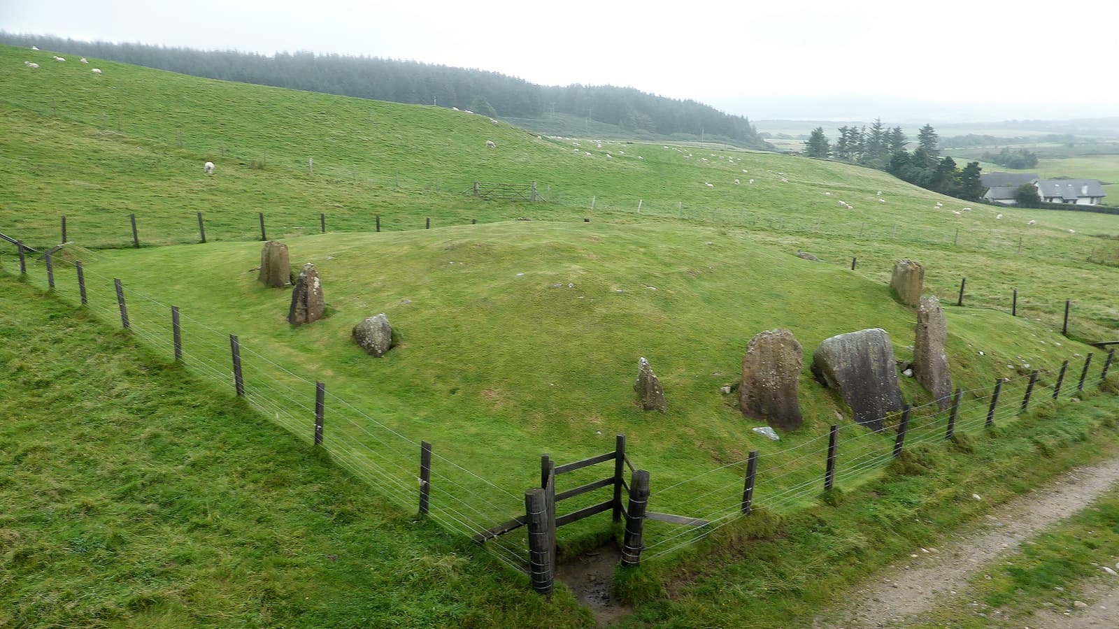
On the west coast of the Isle of Arran, where the coastal road runs between the mountains and the sea, a tall blade of red sandstone rises from a sheep field near Auchencar Farm. At five metres high and scarcely thirty centimetres thick, the stone appears almost impossible, a slender fin of rock tapering to a fine point against the sky. Beside it lies a fallen companion, broken in two, eight metres long when whole. Together they may once have formed part of a larger setting. What makes this stone extraordinary beyond its form is its possible role as the birthplace of the Machrie Moor stone circles five kilometres to the south, one of Scotland's most significant prehistoric ceremonial landscapes.
There are standing stones that impress through mass, through the sheer weight of sarsen or granite hauled into position. The Auchencar Standing Stone impresses through the opposite quality: an almost impossible thinness. Rising five metres from a sheep field on the west coast of Arran, this blade of red sandstone is scarcely thirty centimetres thick, tapering from a base nearly two metres wide to a fine, knife-like point. Its silhouette against the sky of Machrie Bay has the quality of something deliberately shaped, a monument that was carved as much as it was erected. Beside it lies a fallen companion stone, broken into two pieces, that was originally about eight metres long. The two may have formed part of a circular setting, though only the standing stone survives intact. Five thousand years of wind and rain have covered its surface in lichen, softening the red sandstone to grey and green, but the essential form endures. Aubrey Burl, one of the foremost authorities on British stone circles, identified Auchencar as a possible quarry source for the red sandstone circles at Machrie Moor, five kilometres to the south. If he was right, this field is where the raw material of one of Scotland's greatest prehistoric sacred landscapes was born from the earth. The standing stone may have served as a marker of that origin, or as a sentinel along the route between quarry and ceremony. Viewed from the sea, approaching the western coast of Arran, the stone would have been visible from a considerable distance, a thin vertical line against the rounded hills. For people arriving by coracle or currach, it announced that they were entering sacred territory. For those who lived here, it connected the domestic landscape of farm and shore to the ceremonial world of circles and alignments that spread across Machrie Moor.
Context and lineage
Between five and six thousand years ago, on a slope overlooking the western coast of Arran, people chose a piece of red sandstone and shaped it. They worked it into a form unlike the typical standing stones of the island, creating instead a tall, thin blade that rose to a sharp point. They raised this blade in a field above Machrie Bay, where it could be seen from the sea and from the mountains, and where it would stand as a marker in a landscape already rich with sacred meaning. Five kilometres to the south, across the moorland, they were building stone circles from the same red sandstone. Aubrey Burl, who spent a lifetime studying these circles, came to believe that the stone at Auchencar came from the same geological source, and that this field may have been the quarry from which the circles of Machrie Moor were born. Whether the standing stone marked the quarry, guarded it, or served some entirely different purpose in the ceremonial life of western Arran, no one can now say with certainty. What is certain is that the stone has outlasted everything else. The companion stone fell and broke. Whatever setting the two formed has been lost. The people who raised them left no written record. But the blade of red sandstone still stands, thinner than a hand, taller than a house, five thousand years into its vigil over Machrie Bay.
The Auchencar Standing Stone exists within the wider prehistoric ritual landscape of western Arran, which includes the Machrie Moor stone circles (six circles with over 40 individual monuments), the Auchagallon stone circle, and numerous burial cairns and standing stones scattered along the coast. This landscape was in active ceremonial use from approximately 3500 to 1500 BC, a span of two thousand years.
Aubrey Burl
Why this place is sacred
What is it about certain places that stops time? At Auchencar, it may be the sheer improbability of the stone. Standing beside it, you become aware of its proportions in a way that photographs cannot convey. The stone is taller than most rooms, wider than your outstretched arms at the base, yet thinner than your hand. Someone shaped this. Someone chose this particular piece of red sandstone, worked it into this particular form, and raised it here, on this particular slope overlooking Machrie Bay, where the mountains of central Arran rise behind and the Atlantic stretches westward toward Ireland and beyond. There is no interpretation panel. No visitor centre explains the stone's significance. No gift shop sells miniature replicas. You arrive at the field by walking up a farm track, crossing a stile, and entering a world where sheep graze around a monument older than the pyramids. The fallen companion stone lies nearby, broken but enormous, a reminder that time undoes even the most enduring materials. The standing stone persists as if by stubbornness, its thin edge turned to the prevailing winds like a sail set against five millennia of Atlantic weather. Research suggests that around 2000 BC, the star Arcturus would have skimmed along the summit of Beinn Bharrain, visible due north from this spot. Whether or not the stone was intentionally aligned to mark this stellar event, standing here at night one inhabits the same sky that the stone's builders knew. The constellations have shifted, but the stone has not.
The stone likely served multiple purposes within the prehistoric sacred landscape of western Arran. Its prominent visibility from both land and sea suggests it functioned as a landmark and territorial marker. The possible astronomical alignment with Arcturus and Beinn Bharrain indicates it may have served as an observation point for stellar events. Its identification as a possible quarry source for Machrie Moor connects it to the ritual preparation and transportation of sacred materials. The fallen companion and possible circular setting suggest ceremonial use beyond simple waymarking.
The stone was erected between approximately 3800 and 2500 BC by Neolithic or Early Bronze Age communities. At some unknown point, the companion stone fell and broke into two pieces. The site acquired the name 'Druid' in the 18th or 19th century, reflecting romantic antiquarian associations rather than historical fact. The stone was recorded by early antiquarians and eventually listed as a scheduled ancient monument by Historic Environment Scotland (Canmore ID 39210). Aubrey Burl's identification of Auchencar as a quarry source for Machrie Moor brought new scholarly attention to the site. Today it stands in agricultural land near Auchencar Farm, visited by those who know to seek it out.
Traditions and practice
Unknown specifically. The possible astronomical alignment with Arcturus and Beinn Bharrain around 2000 BC suggests seasonal or stellar observation. The quarry connection to Machrie Moor implies the site may have been associated with the ritual preparation and transportation of sacred materials. The stone's visibility from the sea suggests it served as a landmark for maritime approaches.
Personal pilgrimage and contemplative visits. Walking between Auchencar and Machrie Moor, tracing the possible quarry route. Photography of the stone's distinctive silhouette. The stone appears in walking guides and megalithic site databases for those exploring Arran's prehistoric landscape.
Walk from Machrie Bay rather than driving to the farm, if conditions allow. The approach by foot connects you to the landscape in a way that driving cannot. Spend time with both the standing stone and its fallen companion. Walk around the standing stone to see how its form changes from blade-edge to broad face. If conditions and season permit, visit in the evening to see the stone silhouetted against the western sky over Machrie Bay. Consider combining the visit with a walk to Machrie Moor, five kilometres to the south, to experience the full arc of the sacred landscape.
Neolithic/Bronze Age sacred landscape
HistoricalThe stone was erected as part of a sacred landscape that encompassed western Arran from approximately 3800 to 1500 BC. Its possible role as a quarry marker for Machrie Moor and its astronomical alignment with Arcturus suggest complex ceremonial and observational functions.
Astronomical observation, landmark and waymarking, possible ritual quarrying of sacred stone. Specific ceremonial practices are unknown.
Contemporary contemplative visiting
ActiveThe stone attracts visitors seeking unmediated encounter with prehistoric monuments, away from the more accessible and better-known Machrie Moor.
Walking pilgrimage, contemplation, photography. Some visitors walk the route between Auchencar and Machrie Moor, tracing the possible quarry path.
Experience and perspectives
You reach the Auchencar Standing Stone by turning off the A841 coastal road between Machrie and Dougarie, on the west coast of Arran. A narrow lane leads uphill toward Auchencar Farm. Park near the beach at Machrie Bay if the lane is too narrow, and walk. Ask the farmer for permission to enter the field. Cross the stile, and there it is. The stone appears first as a dark vertical line against the sky, its thinness making it almost disappear when seen edge-on. As you approach, the proportions become clear. This is not a squat boulder dragged into position. This is a shaped blade of red sandstone, worked to a taper that would not look out of place among the standing stones of Callanish in the Outer Hebrides, a thousand miles to the north. Stand at the base and look up. The stone leans slightly, as if the wind of millennia has bent it. Touch the surface and feel lichen over sandstone, cool even in summer, rough under the fingertips. The texture is honest, the stone wearing its age without concealment. Walk around to the fallen companion. Here is the other half of whatever this setting once was, broken and recumbent, partially covered in turf. Its eight-metre original length suggests that when both stones stood, the pair would have been remarkable even by the standards of a landscape crowded with prehistoric monuments. From the stone, look south. Five kilometres in that direction, the stone circles of Machrie Moor rise from the peat. If Burl was right that the red sandstone for those circles came from here, you are standing at the origin point, the quarry where the sacred was carved from the earth. Look west over Machrie Bay, where the Atlantic meets the shore. Look north to the mountains. This is threshold landscape, where the domestic world of farming meets the wild space of mountain and ocean, and where a single stone has stood for five thousand years to mark the boundary.
The stone stands in a field near Auchencar Farm, accessible via a stile from the farm track. The standing stone is the upright blade visible from the track. The fallen companion lies approximately 4.5 metres to the southeast. Views extend west over Machrie Bay and north toward Beinn Bharrain.
The Auchencar Standing Stone occupies a distinctive position in Arran's prehistoric landscape as both a monument in its own right and a possible origin point for the Machrie Moor sacred complex.
Aubrey Burl's identification of Auchencar as a potential quarry source for the red sandstone circles at Machrie Moor remains the most significant scholarly contribution to understanding this site. The theory has not been conclusively proven through geological analysis but is widely cited. The stone's form, described as unusual for Arran and reminiscent of the thin, pointed standing stones of the Outer Hebrides at Callanish, has raised questions about inter-island cultural connections in the Neolithic. The possible astronomical alignment with Arcturus and Beinn Bharrain, noted by researchers using astronomical software to reconstruct the sky of 2000 BC, adds a potential observational dimension. The stone is listed as Canmore ID 39210 and is a scheduled ancient monument.
The name 'Druid' reflects 18th and 19th century romantic associations between standing stones and druids, a common pattern across the British Isles. The historical druids postdate the stone by at least two thousand years. Local tradition has associated the stone with the landscape of western Arran without attributing specific folklore or legends to it.
Some visitors and writers interested in earth energies and sacred geography see the stone's prominent position between mountain and sea as indicating its placement on an energy line. The connection to Machrie Moor is sometimes interpreted as evidence that the quarrying and transportation of sacred stone was itself a ritual act, transforming raw material into sacred objects through journey.
Whether the standing stone and fallen companion formed part of a circular setting has not been confirmed. The exact geological relationship between the Auchencar sandstone and the Machrie Moor circles requires further analysis. The nature of the possible Arcturus alignment and whether it was intentional remains unresolved. The cultural connections suggested by the stone's Callanish-like form are intriguing but unexplored. Why the companion stone fell, and when, is unknown.
Visit planning
The Isle of Arran offers accommodation in Brodick, Lamlash, Whiting Bay, and smaller villages. Self-catering cottages near Machrie provide the closest base. The island has hotels, B&Bs, a hostel, and campsites. Book ferry and accommodation well in advance during summer months.
Seek permission from the farmer. Close gates. Respect the agricultural setting and the scheduled monument.
Sturdy footwear suitable for walking in fields, which can be muddy. Waterproof layers for Scottish weather.
Freely permitted. The stone photographs well from all angles, especially silhouetted against the western sky.
None should be left. The stone is a scheduled ancient monument in a working field.
The stone is a scheduled ancient monument; any disturbance is illegal. The field is private agricultural land. Access may be limited during lambing season.
Plan your visit
Address
Auchangallon Jetty, Isle of Arran KA27 8DZ, UK
Hours
Hours, fees, and access can change — verify on the official source before you travel. Practical details last checked Jun 2026.
Nearby sacred places
Sacred places within a half-day’s reach. Pilgrims often visit them together: walk one, stay for the other.


References
Sources consulted when researching this page. Independent verification by readers is welcome.
- 01Arran, Druid - Standing Stone (Prehistoric) - Canmore — Historic Environment Scotland / Canmorehigh-reliability
- 02Machrie Moor Standing Stones: History - Historic Environment Scotland — Historic Environment Scotlandhigh-reliability
- 03Auchencar [Druid] Standing Stones - The Megalithic Portal — The Megalithic Portal
- 04Druid Auchencar - Isle of Albion — Isle of Albion
- 05Standing stones, 170m north west of Druid Barn - Ancient Monuments UK — Ancient Monuments UK
- 06Druid Auchencar - The Modern Antiquarian — The Modern Antiquarian
- 07Machrie Moor Stone Circles - Wikipedia — Wikipedia contributors
- 08Auchencar Druid Standing Stone, Arran - Britain Express — Britain Express
- 09Druid Auchencar Standing Stone - Arran Online — Arran Online
- 10Standing Stones - Visit Arran — Visit Arran
Key questions
What pilgrims usually ask
- Why is Auchencar Standing Stone considered sacred?
- Visit the Auchencar Standing Stone on the Isle of Arran, a 5-metre blade of red sandstone dating to 3800-2500 BC, possible quarry source for Machrie Moor.
- What should I wear at Auchencar Standing Stone?
- Sturdy footwear suitable for walking in fields, which can be muddy. Waterproof layers for Scottish weather.
- Can I take photos at Auchencar Standing Stone?
- Freely permitted. The stone photographs well from all angles, especially silhouetted against the western sky.
- How long should I spend at Auchencar Standing Stone?
- 1 hour including approach walk and contemplation
- What offerings are appropriate at Auchencar Standing Stone?
- None should be left. The stone is a scheduled ancient monument in a working field.
- What etiquette should visitors follow at Auchencar Standing Stone?
- Seek permission from the farmer. Close gates. Respect the agricultural setting and the scheduled monument.
- What is the history of Auchencar Standing Stone?
- Between five and six thousand years ago, on a slope overlooking the western coast of Arran, people chose a piece of red sandstone and shaped it. They worked it into a form unlike the typical standing stones of the island, creating instead a tall, thin blade that rose to a sharp point. They raised this blade in a field above Machrie Bay, where it could be seen from the sea and from the mountains, and where it would stand as a marker in a landscape already rich with sacred meaning. Five kilometres to the south, across the moorland, they were building stone circles from the same red sandstone. Aubrey Burl, who spent a lifetime studying these circles, came to believe that the stone at Auchencar came from the same geological source, and that this field may have been the quarry from which the circles of Machrie Moor were born. Whether the standing stone marked the quarry, guarded it, or served some entirely different purpose in the ceremonial life of western Arran, no one can now say with certainty. What is certain is that the stone has outlasted everything else. The companion stone fell and broke. Whatever setting the two formed has been lost. The people who raised them left no written record. But the blade of red sandstone still stands, thinner than a hand, taller than a house, five thousand years into its vigil over Machrie Bay.
- Who is associated with Auchencar Standing Stone?
- Aubrey Burl