Ring of Bookan
An unexcavated threshold between the domestic and the sacred in Neolithic Orkney's ceremonial heartland
Stromness, Orkney Islands, United Kingdom
Plan this visit
Practical context before you go
Allow one to two hours for the walk from the Brodgar area and time at the monument. A full day permits exploration of the broader Heart of Neolithic Orkney landscape, including Ring of Brodgar, Stones of Stenness, Barnhouse, and the Ness of Brodgar interpretation area.
The Ring of Bookan is approximately 1.6 km northwest of the Ring of Brodgar on Mainland Orkney. Access is on foot across open moorland. A path exists but conditions can be wet. Park at the Stones of Stenness car park or the Ring of Brodgar layby and walk. The site is not accessible by vehicle. The uneven, boggy terrain makes wheelchair access difficult.
The Ring of Bookan is a scheduled ancient monument on open Orkney moorland. Visitors should respect its protected status, leave no trace, and come prepared for exposed, potentially wet conditions.
At a glance
- Coordinates
- 59.0116, -3.2494
- Type
- Henge
- Suggested duration
- Allow one to two hours for the walk from the Brodgar area and time at the monument. A full day permits exploration of the broader Heart of Neolithic Orkney landscape, including Ring of Brodgar, Stones of Stenness, Barnhouse, and the Ness of Brodgar interpretation area.
- Access
- The Ring of Bookan is approximately 1.6 km northwest of the Ring of Brodgar on Mainland Orkney. Access is on foot across open moorland. A path exists but conditions can be wet. Park at the Stones of Stenness car park or the Ring of Brodgar layby and walk. The site is not accessible by vehicle. The uneven, boggy terrain makes wheelchair access difficult.
Pilgrim tips
- Waterproof jacket and trousers advisable in all seasons. Sturdy, waterproof footwear essential; the approach is boggy. Layers for changeable conditions. Wind protection is more important than warmth for much of the year.
- Photography is freely permitted. The monument photographs well when cloud shadows move across it, and the views south toward Brodgar are worth capturing. Drone use may require permissions within the World Heritage buffer zone.
- The Ring of Bookan is a scheduled ancient monument and must not be disturbed. Do not dig, remove stones, or alter the earthworks in any way. The site is unexcavated, and any disturbance could destroy irreplaceable archaeological evidence. The approach across open moorland can be boggy and exposed to severe weather. Check conditions before setting out. There are no facilities or shelter at the site.
Overview
On a windswept rise northwest of the Ring of Brodgar, a broad ditch and raised platform mark where Neolithic people placed a monument at the boundary between the everyday and the extraordinary. The Ring of Bookan has never been excavated, and so it keeps its purposes to itself. What is known is its position: the precise point where the great ceremonial monuments of the Brodgar peninsula first come into view. Five thousand years ago, someone decided that this threshold needed marking. The mark endures.
The Ring of Bookan is the monument you walk past on your way to see the famous ones. That may be exactly how it was meant to work.
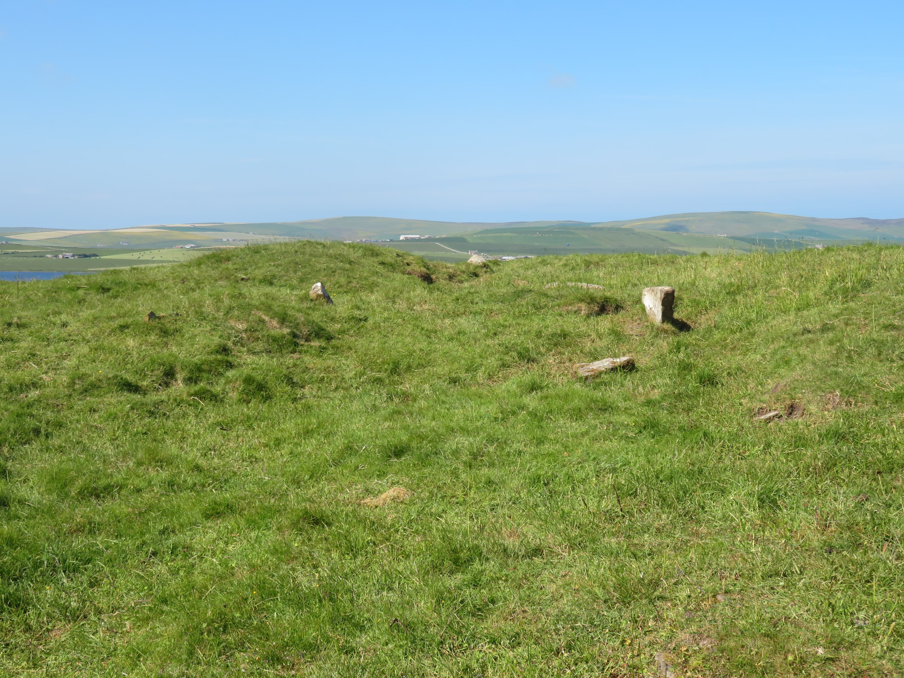
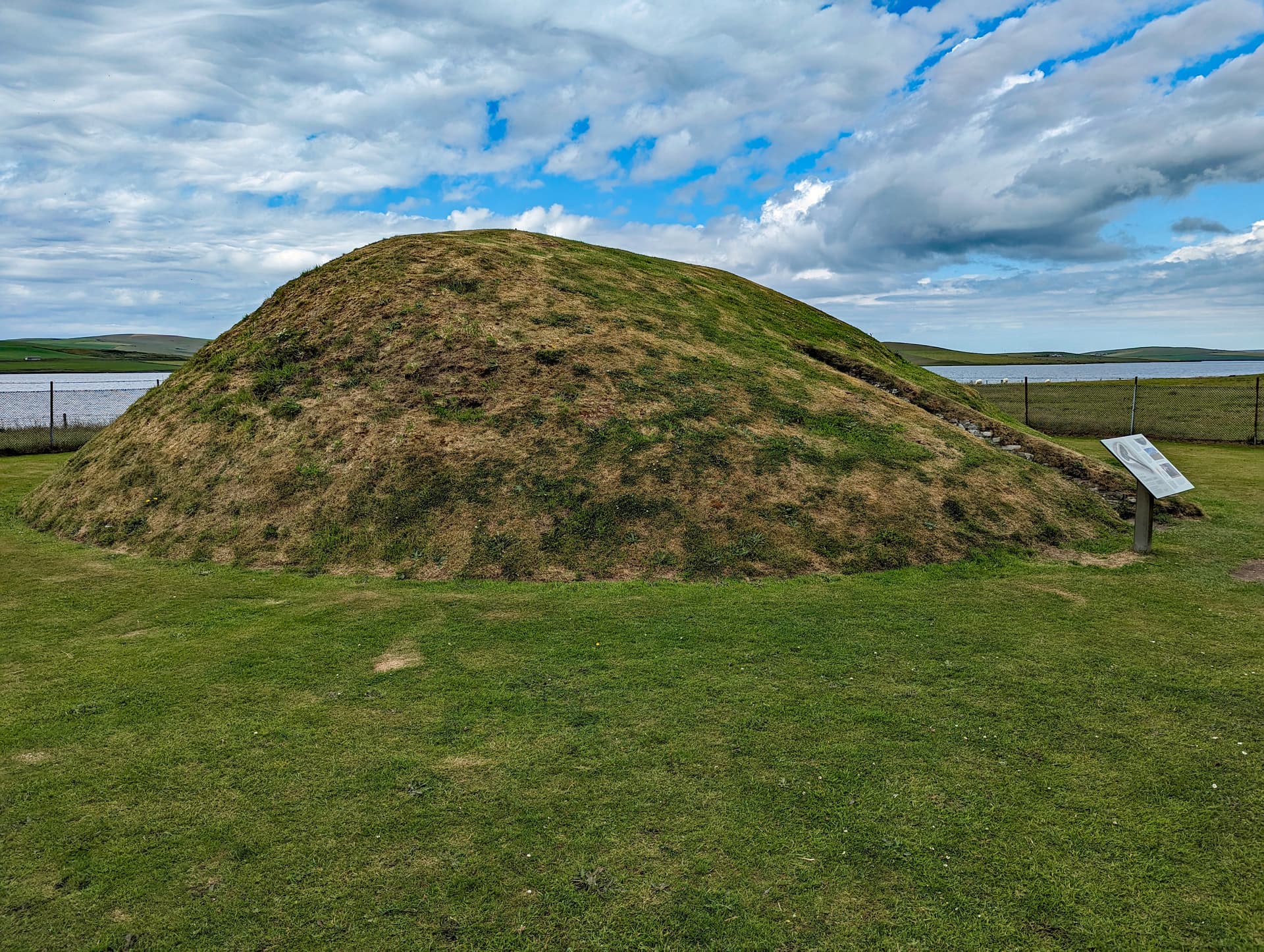
Sitting on elevated ground roughly a mile and a half northwest of the Ring of Brodgar, this broad earthwork consists of a ditch some thirteen metres wide and at least two metres deep, enclosing a raised platform approximately forty metres across. Interior stone stumps, a central triangular block, and traces of small circular features hint at purposes no one has yet been able to confirm, because in all the centuries of antiquarian interest in Orkney, no one has turned a spade in this ground.
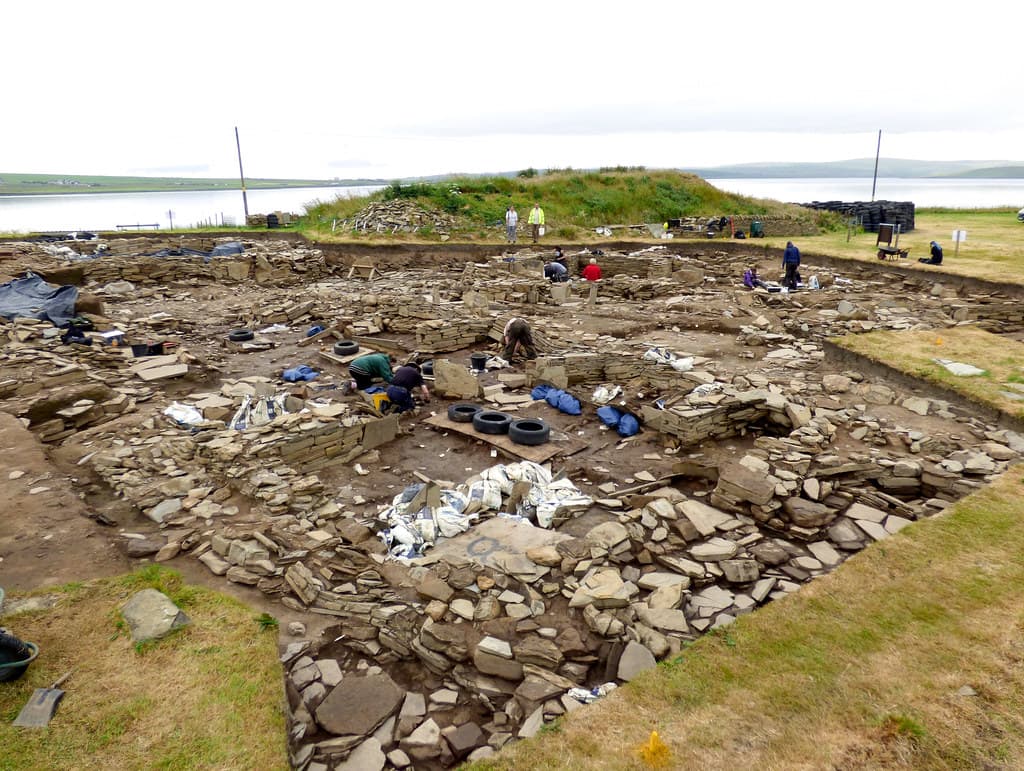
What geophysical surveys have revealed is surprising. The ditch, which appears oval to the eye, is in fact sub-rectangular with rounded corners. A thick clay platform covers the interior remains, a construction technique known from both the Barnhouse settlement and the great passage tomb of Maeshowe. The Ring of Bookan may not be a henge at all but something closer to the monumental Neolithic buildings unearthed at the Ness of Brodgar, those structures too architecturally ambitious to be mere houses.
Archaeologist Nick Card has observed that when walking along the ridge from the north, it is not until you reach the Ring of Bookan that the Brodgar peninsula and its sacred monuments finally come into view. The ring may have been placed here deliberately as a threshold, the point where the domestic world of settlements gives way to the ceremonial world of stone circles and passage tombs. If so, it is a monument not to arrival but to transition, marking the moment when one crosses from one kind of landscape into another.
Context and lineage
No founding narrative survives. The Ring of Bookan predates written history by at least three thousand years, and whatever stories its builders told about it have been lost entirely. The monument speaks only through its position in the landscape, its scale, and the few interior features visible on the surface.
What the landscape itself narrates is a story of sustained investment. Over roughly fifteen hundred years, from about 3500 to 2000 BC, the communities of this corner of Orkney built passage tombs, stone circles, monumental buildings, and enclosures along the isthmus between two lochs. The Ring of Bookan was part of this programme, though whether early or late, central or peripheral, remains unknown. What is clear is that its placement was deliberate and its construction costly in labor.
The Ring of Bookan has no continuous lineage of spiritual practice. Its builders left no written record and no oral tradition has survived the intervening millennia. What has survived is the monument itself and the landscape it inhabits.
The archaeological lineage begins in 1848 with Thomas and continues through Petrie, Childe, Henshall, Ritchie, and most recently the Ness of Brodgar project team. Each generation of scholars has reinterpreted the site in light of new evidence and new frameworks. The geophysical surveys of the twenty-first century have been particularly transformative, revealing a sub-rectangular structure covered by a clay platform rather than the simple oval henge previously assumed.
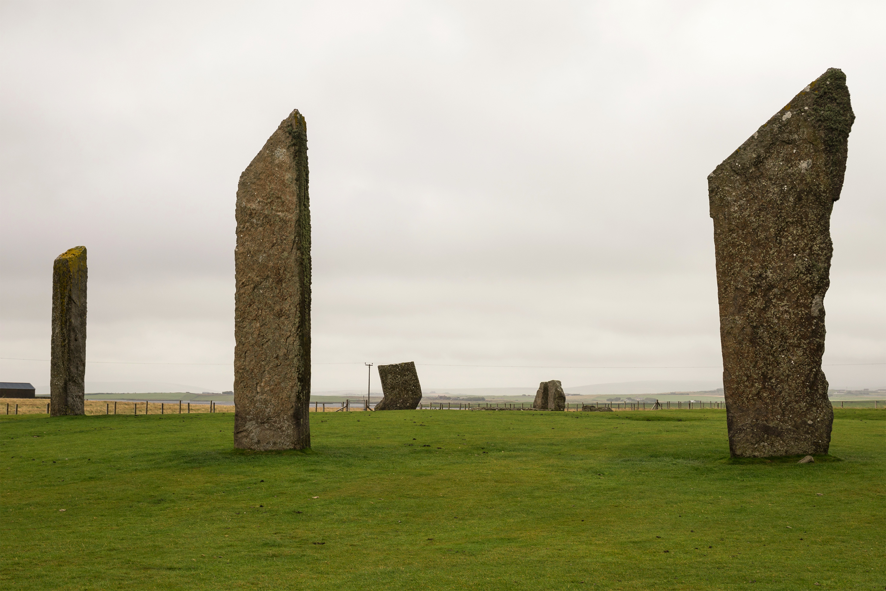
The Ring of Bookan's true lineage, however, is topographical. It belongs to the landscape, and the landscape has been recognized as sacred for at least five thousand years. The Stones of Stenness, the Ring of Brodgar, Maeshowe, the Ness of Brodgar, and Skara Brae form a constellation of Neolithic sites that together constitute one of the most remarkable sacred landscapes in the world. The Ring of Bookan is a quieter member of this constellation, but its position at the threshold of the ceremonial precinct may make it, in some sense, the first.
Lieutenant F.W.L. Thomas
antiquarian
First to document the Ring of Bookan in 1848, noting that it had escaped the notice of all previous observers of the Stenness antiquities. Concluded it was of the same genus as the Ring of Brodgar.
George Petrie
antiquarian
Orcadian antiquary who produced detailed plans of the Ring of Bookan in the nineteenth century, documenting a circular space 136 feet in diameter enclosed by a trench 44 feet wide and 6 feet deep.
Nick Card
archaeologist
Director of excavations at the Ness of Brodgar who has suggested the Ring of Bookan served as a demarcation between the domestic settlement area to the north and the sacred monuments below on the Brodgar peninsula.
Audrey Henshall
scholar
Classified the Ring of Bookan as a chambered tomb of Maes Howe type rather than a henge, contributing to the ongoing debate about the monument's nature.
Why this place is sacred
There are places whose significance is immediately apparent: a towering stone circle, a great burial chamber, a cathedral of dressed stone. The Ring of Bookan is not one of these. Its power resides in what it withholds.
Lieutenant Thomas, the first antiquarian to describe it in 1848, noted that the ring 'seems to have escaped the notice of all those who had described the antiquities of Stenness.' He added that it 'may indeed be easily passed without attracting attention.' The absence of standing stones, the feature that draws visitors to Brodgar and Stenness, meant that Bookan was largely ignored for centuries.
And yet someone, five thousand years ago, invested enormous communal labor in digging a ditch thirteen metres wide and two metres deep into the Orkney bedrock. The effort involved would have been comparable to what was required for the Ring of Brodgar. Thomas himself concluded that Bookan was 'of the same genus' as Brodgar. Whatever drove its construction, it was not casual.
The Ring of Bookan stands at a geographical and perhaps metaphysical boundary. To its north, geophysical surveys have confirmed the presence of a large Neolithic settlement complex. To its south, the land drops away to reveal the Brodgar peninsula with its stone circles, its passage tombs, its Ness of monumental buildings. The ring sits precisely at the hinge between these two worlds.
Visitors who come here after the crowds of Brodgar report something difficult to name. Perhaps it is the solitude. Perhaps it is the knowledge that whatever lies beneath the clay platform has remained undisturbed for five millennia. Perhaps it is the view itself, looking south across the lochs to where the stones still stand, and knowing that you are seeing what Neolithic people saw as they crossed from one reality into another.
The original purpose of the Ring of Bookan remains genuinely unknown. The classification has been debated for over a century. Childe called it a Class II henge monument. Henshall classified it as a chambered tomb of Maes Howe type. Graham Ritchie, who excavated at the Stones of Stenness, suggested it was a henge monument with internal stone settings or a cairn. Recent geophysical surveys have revealed similarities to the monumental structures at Barnhouse and the Ness of Brodgar, dating from approximately 2900 BC. Nick Card has proposed it functioned as a demarcation between settlement areas to the north and the sacred ceremonial landscape to the south. Without excavation, all interpretations remain provisional. The monument keeps its own counsel.
The Ring of Bookan appears to have been built and used during the Neolithic period, roughly contemporary with the other great monuments of the Brodgar peninsula. Its history since then is largely one of quiet persistence. Thomas's 1848 description was the first written account. George Petrie produced detailed plans in the nineteenth century, documenting the ditch dimensions and interior stone features. The site was designated as a scheduled monument on 28 June 1938, protecting it from disturbance. Modern geophysical surveys conducted as part of the Ness of Brodgar project have revealed the sub-rectangular form and clay platform, fundamentally altering scholarly understanding of the monument. A large Neolithic settlement has been confirmed to the north, suggesting that the ring's relationship to domestic space was as deliberate as its relationship to ceremonial space.
Traditions and practice
The original ceremonies performed at the Ring of Bookan, if ceremonies were indeed its purpose, are entirely unknown. The site has never been excavated, and the interior features visible on the surface offer only tantalizing hints: stone stumps, a triangular central block, traces of small circular features. Whether these indicate a chambered tomb, a henge, a monumental building, or something without modern analogy is the subject of ongoing scholarly debate.
What can be inferred from the monument's position is a relationship to movement through the landscape. The ring sits at the point where the Brodgar peninsula and its sacred monuments become visible from the north. If it functioned as a threshold, then the practices associated with it may have involved transition: rituals of entering and leaving the ceremonial precinct, perhaps marking the shift from everyday life to sacred time.
The Ring of Bookan does not currently host organized ceremonies or regular spiritual gatherings. Individual visitors occasionally incorporate it into a contemplative walk through the Heart of Neolithic Orkney landscape. Some visitors engaged in meditation or earth mystery practices include the ring in their explorations of the broader ceremonial complex.
The Ness of Brodgar excavation project has renewed interest in the ring as a key element of the Neolithic landscape. As understanding of the monument grows, its role in how visitors engage with the broader World Heritage Site may evolve.
The Ring of Bookan rewards presence rather than performance. Walk the approach from the south, paying attention to the moment when the Brodgar monuments disappear from view and then reappear as you reach the ring. This transition is the experience the monument offers.
On the raised platform, simply stand. Let the wind and the sky do their work. The views from this point encompass the entire ceremonial heart of Neolithic Orkney, and the act of looking is itself a form of participation in what the monument seems to have been designed to frame.
If you wish, walk the perimeter of the ditch. Feel the scale of what was dug here. Then sit, if the ground permits, and consider that no one has disturbed what lies beneath this platform in five thousand years. The weight of that continuity is itself a form of encounter.
Neolithic Ceremonial Landscape Tradition
HistoricalThe Ring of Bookan was constructed as part of the Heart of Neolithic Orkney ceremonial landscape, one of the most significant concentrations of Neolithic sacred monuments in Europe. Its position at the threshold between settlement and ceremony suggests a role in the ritual geography of the landscape. The scale of its ditch indicates communal investment comparable to the Ring of Brodgar. Geophysical evidence links its construction techniques to other major Neolithic monuments in the area, including Barnhouse Structure Eight and Ness of Brodgar Structure Ten, both dating to approximately 2900 BC.
Unknown. The site has never been excavated and no specific practices are documented. The monument's position suggests a possible role in processional or transitional rituals as people moved between the domestic and ceremonial zones of the landscape.
Experience and perspectives
You are unlikely to have company. The Ring of Bookan receives a fraction of the visitors who come to its famous neighbors, and this solitude is part of what it offers. The path from the Brodgar area crosses open moorland, boggy in places, exposed to whatever wind Orkney has decided to send. The monument does not announce itself from a distance. You find it by walking until the ground changes.
The ditch is the first thing that registers. After five thousand years of weathering and silting, it remains impressive, a broad depression circling a raised central platform. Standing on the platform, the sense of enclosure is subtle but present. The interior stone stumps are scattered without obvious pattern, though the triangular block at the centre draws the eye.
Then you look south, and the landscape explains the monument. The Ring of Brodgar appears in the middle distance, its surviving stones catching the light across the loch. The Stones of Stenness stand further on. Between them, though invisible from here, lies the Ness of Brodgar, where archaeologists have unearthed some of the most remarkable Neolithic buildings in Europe. The entire ceremonial heart of Neolithic Orkney lies before you.
Look behind you, to the north, and you see different ground: the undulating terrain where Neolithic settlements have been confirmed by survey. The ring sits precisely at the joint between these worlds. Standing here, you are doing what Neolithic people did: crossing a threshold that someone thought important enough to mark with years of communal labor.
The wind is constant. The sky in Orkney moves fast, cloud shadows racing across the lochs. In this exposed place, the elements are not background but participants.
Approach the Ring of Bookan from the south, walking from the Ring of Brodgar area. This allows you to arrive as the Neolithic settlement dwellers may have arrived, crossing the moorland from the direction of the ceremonial monuments. The walk takes twenty to thirty minutes and the path can be wet, so wear waterproof boots.
As you approach, notice the moment when the Brodgar peninsula disappears from view behind you. This is the transition the monument marks. When you reach the ring and turn south, the view opens again. The monuments reappear.
Spend time on the raised platform within the ditch. The stone stumps do not form an obvious pattern, and that uncertainty is part of the encounter. Something stood here. Something was arranged with care. What it was, no one living knows.
If the day is clear, take time to study the full panorama. The lochs of Stenness and Harray stretch to the south and east. The Orkney hills roll to the west. The settlement landscape lies behind you to the north. The ring sits at the centre of all of it.
Return by the same path, or continue north to explore the broader landscape. The monument rewards a slow approach and an unhurried departure.
The Ring of Bookan resists definitive interpretation, and this resistance is part of its character. Scholars have debated its classification for over a century without resolution. The absence of excavation means that every interpretation remains provisional, and the monument retains a quality of genuine mystery that many better-known sites have lost.
The scholarly debate over the Ring of Bookan is itself instructive. Childe classified it as a Class II henge monument. Feachem saw only an attenuated relationship to henges. Henshall classified it as a chambered tomb of Maes Howe type. Graham Ritchie, drawing on his excavation of the Stones of Stenness, suggested it was a henge with internal stone settings or a cairn. The Ness of Brodgar project's geophysical surveys have added another layer of complexity by revealing the sub-rectangular form and clay platform, drawing comparisons to the monumental structures at Barnhouse (Structure Eight) and the Ness of Brodgar (Structure Ten), both dating to approximately 2900 BC.
Nick Card's interpretation of the ring as a threshold between domestic and sacred landscapes offers a functional explanation that sidesteps the classification debate. Whether henge, tomb, or monumental building, the ring occupies a position of deliberate topographical significance. The confirmation of a large Neolithic settlement to the north strengthens this interpretation by establishing the domestic landscape from which the threshold leads.
No traditional or indigenous spiritual perspective on the Ring of Bookan has survived. The monument predates the arrival of Norse, Pictish, and Celtic cultures in Orkney, and the Neolithic communities who built it left no oral or written traditions that have reached the present day. The Ring of Bookan exists in a space beyond the reach of any living tradition.
The Ring of Bookan has attracted some interest from earth mystery and sacred geometry researchers. The observation that the three major circular monuments of the landscape, the Stones of Stenness, the Ring of Brodgar, and the Ring of Bookan, form a linear arrangement has prompted comparison to Orion's Belt, though this remains speculative. The ring's position at a topographical threshold has resonated with those who understand sacred landscapes as deliberately structured to shape consciousness and movement through space.
The Ring of Bookan is defined by what remains unknown. The site has never been excavated, and the scholarly debate over its classification, whether henge, chambered tomb, or monumental building, cannot be resolved without excavation. The date of construction is uncertain. The function of the interior stone settings, the triangular central block, and the small circular features reported by antiquarians is unexplained. The relationship between the ring and the newly discovered settlement complex to its north has not been explored. The thick clay platform covering the interior remains, paralleling techniques at Barnhouse and Maeshowe, hints at deliberate concealment or transformation of whatever originally stood here. Five thousand years of silence is a long time, and the Ring of Bookan shows no sign of breaking it soon.
Visit planning
The Ring of Bookan is approximately 1.6 km northwest of the Ring of Brodgar on Mainland Orkney. Access is on foot across open moorland. A path exists but conditions can be wet. Park at the Stones of Stenness car park or the Ring of Brodgar layby and walk. The site is not accessible by vehicle. The uneven, boggy terrain makes wheelchair access difficult.
Stromness, approximately 6 km southwest, offers hotels, guesthouses, and self-catering accommodation. Kirkwall, the main town of Orkney (approximately 20 km east), has a wider range of options. Several farmhouse bed and breakfasts operate in the Stenness area. Orkney is accessible by ferry from Scrabster and Aberdeen, and by air from Scottish mainland airports.
The Ring of Bookan is a scheduled ancient monument on open Orkney moorland. Visitors should respect its protected status, leave no trace, and come prepared for exposed, potentially wet conditions.
Waterproof jacket and trousers advisable in all seasons. Sturdy, waterproof footwear essential; the approach is boggy. Layers for changeable conditions. Wind protection is more important than warmth for much of the year.
Photography is freely permitted. The monument photographs well when cloud shadows move across it, and the views south toward Brodgar are worth capturing. Drone use may require permissions within the World Heritage buffer zone.
Do not leave offerings on or near the scheduled monument. The site's integrity depends on remaining undisturbed. If you wish to mark your visit, do so internally.
The Ring of Bookan is a scheduled ancient monument (SM1370). Disturbance, excavation, or metal detecting are prohibited by law. No specific hours of access; the site is on open moorland. Be mindful of livestock and close gates.
Plan your visit
Address
Mainland,, Orkney, Stromness KW16 3HY, UK
Hours
Hours, fees, and access can change — verify on the official source before you travel. Practical details last checked Jun 2026.
Nearby sacred places
Sacred places within a half-day’s reach. Pilgrims often visit them together: walk one, stay for the other.

References
Sources consulted when researching this page. Independent verification by readers is welcome.
- 01The Ring of Bookan — The Ness of Brodgar Projecthigh-reliability
- 02Ring Of Bookan - Canmore — Historic Environment Scotland / Canmorehigh-reliability
- 03Heart of Neolithic Orkney — UNESCO World Heritage Centrehigh-reliability
- 04The Bookan Chambered Cairn — The Ness of Brodgar Projecthigh-reliability
- 05Scheduled Monument SM1370 - Ring of Bookan — Historic Environment Scotlandhigh-reliability
- 06Ring of Bookan (Henge) near Stromness, Orkney — The Modern Antiquarian
- 07Ring of Buikan — Experience Orkney Tours
- 08Ring of Bookan — Ancient Scotland
Key questions
What pilgrims usually ask
- Why is Ring of Bookan considered sacred?
- Discover the Ring of Bookan, an unexcavated Neolithic monument in Orkney marking the threshold to the Heart of Neolithic Orkney World Heritage landscape.
- What should I wear at Ring of Bookan?
- Waterproof jacket and trousers advisable in all seasons. Sturdy, waterproof footwear essential; the approach is boggy. Layers for changeable conditions. Wind protection is more important than warmth for much of the year.
- Can I take photos at Ring of Bookan?
- Photography is freely permitted. The monument photographs well when cloud shadows move across it, and the views south toward Brodgar are worth capturing. Drone use may require permissions within the World Heritage buffer zone.
- How long should I spend at Ring of Bookan?
- Allow one to two hours for the walk from the Brodgar area and time at the monument. A full day permits exploration of the broader Heart of Neolithic Orkney landscape, including Ring of Brodgar, Stones of Stenness, Barnhouse, and the Ness of Brodgar interpretation area.
- How do you visit Ring of Bookan?
- The Ring of Bookan is approximately 1.6 km northwest of the Ring of Brodgar on Mainland Orkney. Access is on foot across open moorland. A path exists but conditions can be wet. Park at the Stones of Stenness car park or the Ring of Brodgar layby and walk. The site is not accessible by vehicle. The uneven, boggy terrain makes wheelchair access difficult.
- What offerings are appropriate at Ring of Bookan?
- Do not leave offerings on or near the scheduled monument. The site's integrity depends on remaining undisturbed. If you wish to mark your visit, do so internally.
- What etiquette should visitors follow at Ring of Bookan?
- The Ring of Bookan is a scheduled ancient monument on open Orkney moorland. Visitors should respect its protected status, leave no trace, and come prepared for exposed, potentially wet conditions.
- What is the history of Ring of Bookan?
- No founding narrative survives. The Ring of Bookan predates written history by at least three thousand years, and whatever stories its builders told about it have been lost entirely. The monument speaks only through its position in the landscape, its scale, and the few interior features visible on the surface. What the landscape itself narrates is a story of sustained investment. Over roughly fifteen hundred years, from about 3500 to 2000 BC, the communities of this corner of Orkney built passage tombs, stone circles, monumental buildings, and enclosures along the isthmus between two lochs. The Ring of Bookan was part of this programme, though whether early or late, central or peripheral, remains unknown. What is clear is that its placement was deliberate and its construction costly in labor.