Reineval Chambered Cairn
A Neolithic passage grave on an exposed Hebridean hillside, sealed for five thousand years, waiting in wind and stone
Lochboisdale, United Kingdom
Plan this visit
Practical context before you go
1 to 1.5 hours including the approach, a full circumnavigation, time at the passage entrance, and contemplation
Respect the scheduled monument. Do not climb on the cairn, remove stones, or dig. Leave no trace. Respect the working farmland on the approach.
At a glance
- Coordinates
- 57.2084, -7.3782
- Type
- Chambered Cairn
- Suggested duration
- 1 to 1.5 hours including the approach, a full circumnavigation, time at the passage entrance, and contemplation
Pilgrim tips
- Dress for exposed Hebridean moorland in all seasons. Waterproof jacket and overtrousers are essential. Walking boots with ankle support are strongly recommended. The approach track is often muddy and the ground around the cairn is rough, uneven, and covered in heather. Conditions can change rapidly: sun, wind, and rain may alternate within minutes. In summer, midges can be fierce in calm weather, so insect repellent or a head net may be welcome.
- Photography is freely permitted and encouraged. The cairn photographs well from multiple angles. The peristalith stones are most dramatic in low-angle light during early morning or late evening. The mound against the Hebridean sky in changing weather provides striking compositions. Aerial and drone photography has produced revealing images of the cairn's circular form, though pilots should check current regulations for the area.
- The terrain is uneven with heather, peat, and exposed rock. Walking boots are essential. The approach track can be very muddy after rain. There is no shelter at the site and conditions can change rapidly. Do not attempt to enter the passage or disturb any stones. The cairn is a scheduled monument and any disturbance is illegal.
Overview
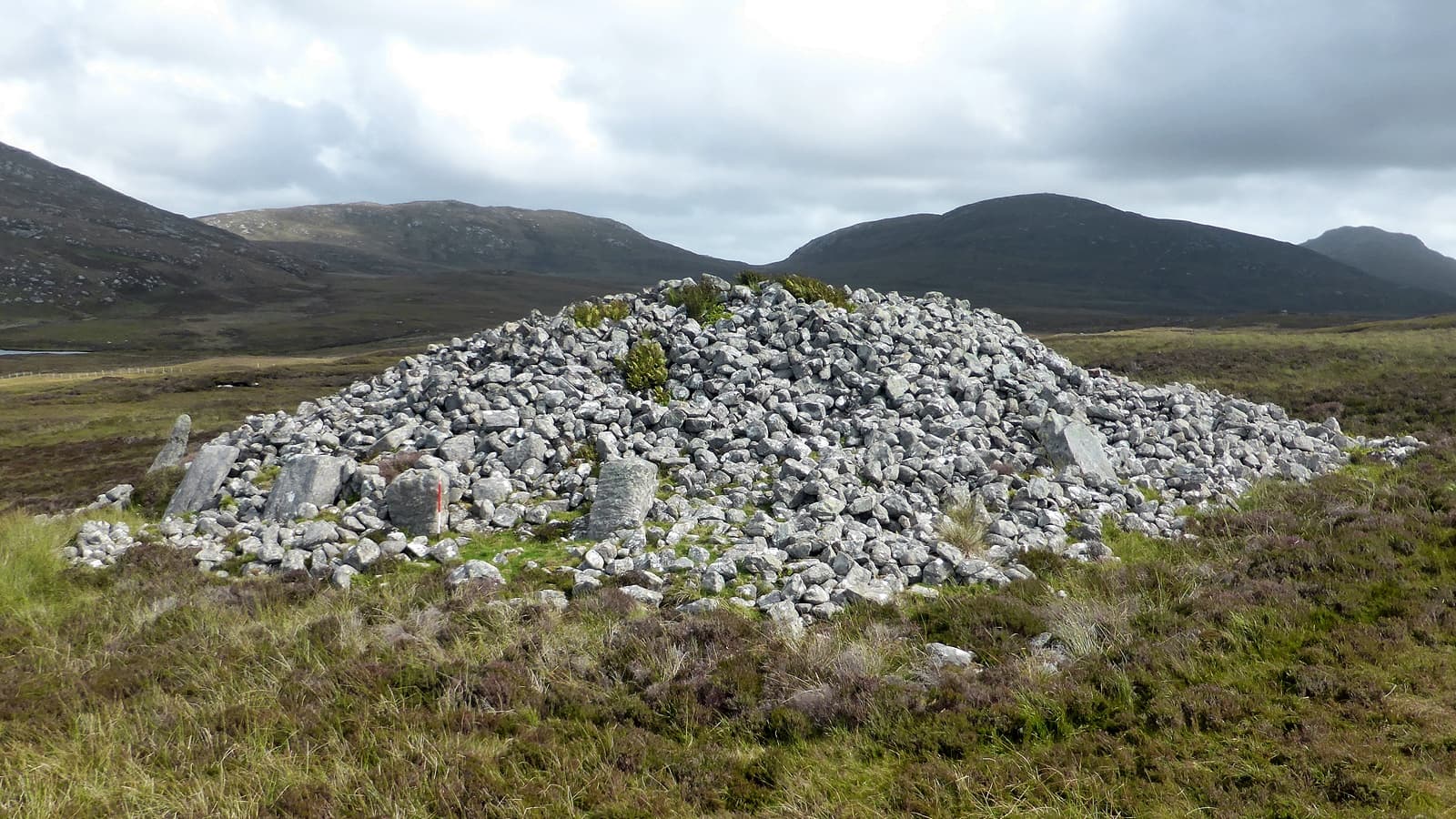
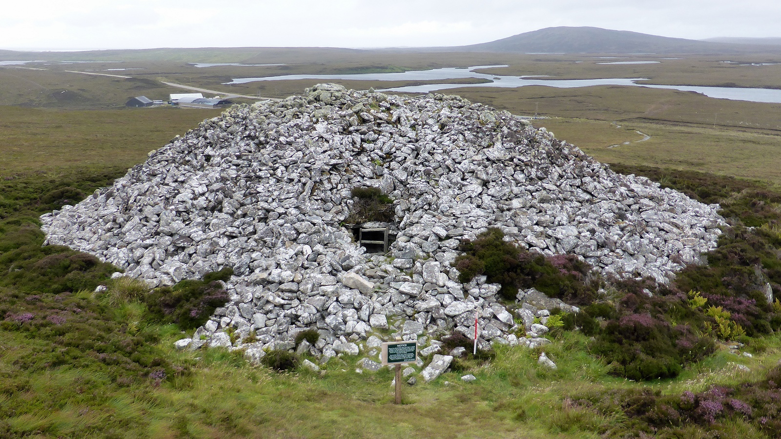
On the northern slope of Beinn Reineabhal, overlooking the valley that descends to Mingarry and the Atlantic beyond, a massive stone mound rises from the moorland. Reineval Chambered Cairn was built roughly five thousand years ago by the earliest farming communities of South Uist. Twelve great upright slabs still stand in a broken ring around the base. The entrance passage faces east-southeast. The burial chamber remains sealed beneath a capstone weighing several tonnes. No one has opened it in recorded history.
You approach from Mingarry along a farm track that turns to rough ground as the land rises. The mound appears gradually, resolving from the heather and peat as you climb. It stands nearly four metres high and over twenty metres across, a deliberate and monumental presence on this open hillside at a hundred feet above sea level. The builders chose this place. They dragged stone slabs up the slope, some measuring nearly two metres in length, and stood them upright in a rough circle to form the peristalith, the ring of kerb-stones that defines the cairn's perimeter. Twelve of these slabs survive, mostly visible in the northwest quadrant, their faces angled against the prevailing wind.
The entrance passage, about a metre wide, can be traced for over three metres on the east-southeast side. It leads inward toward a burial chamber that has never been formally excavated. A massive slab, roughly 1.8 metres long and 1.4 metres broad, lies exposed toward the east, probably the capstone that once sealed the chamber. Beneath it, the dead of a Neolithic community were placed in darkness, their identities and stories absorbed into the stone.
Reineval belongs to the Hebridean group of round chambered cairns, a type defined by the archaeologist Audrey Henshall and found across the Western Isles. Six examples stand on South Uist alone, sharing common features: circular peristaliths, facades on their southern or eastern sides, funnel-shaped forecourts, and short passages leading to simple chambers. These cairns were not isolated monuments. Boyle Somerville documented that Reineval, Barp Frobost, and Askervein lie on a precise north-south meridian line, with orientations to the equinoctial sunrise and winter solstice sunrise. The builders appear to have placed their houses for the dead within a wider cosmological framework that linked landscape, burial, and the movements of the sun.
Context and lineage
Sometime between 3500 and 3000 BCE, the Neolithic farming communities of South Uist began constructing monumental chambered cairns on prominent hillsides across the island. These were among the earliest permanent settlers of the Outer Hebrides, people who had brought domesticated crops and livestock to the islands and who now possessed the social cohesion and surplus labor required for monumental building.
Reineval was one of six round cairns they built on South Uist, each sharing a distinctive architectural vocabulary. Large stone slabs, some nearly two metres long, were transported uphill and stood upright to form a circular peristalith. A facade was constructed on the eastern side, creating a funnel-shaped forecourt that funnelled approach toward the entrance passage. The passage, barely a metre wide, led inward to a central chamber where the dead were placed. A massive capstone sealed the chamber. The cairn mound was built up around and over the entire structure, rising to nearly four metres in height and over twenty metres in diameter.
The cairn was not an isolated monument. All six round cairns on South Uist share common features and occupy prominent landscape positions with extensive views. Boyle Somerville, a Vice-Admiral and amateur archaeologist working in the early twentieth century, documented that Reineval, Barp Frobost to the south, and Askervein further south again lie on a precise north-south meridian line. He noted orientations to the equinoctial sunrise and winter solstice sunrise, suggesting that the placement of these burial monuments encoded astronomical relationships that connected the cycle of death with the cycle of the sun.
The cairn was built to last, and it has lasted. No formal excavation has ever been conducted, so the chamber contents remain unknown. The monument stands on its hillside essentially as the last Neolithic users left it, weathered by five millennia of Hebridean weather but structurally intact. The dead within, if they remain, have lain undisturbed in darkness for longer than any written history records.
Reineval belongs to the Hebridean group of round chambered cairns, a type found across the Western Isles of Scotland and defined by circular peristaliths, short entrance passages, simple chambers, and prominent landscape positions. These cairns appear relatively late in the Scottish Neolithic sequence, broadly contemporary with the Maeshowe-type passage graves of Orkney and the Clyde-type cairns of western Scotland, though architecturally distinct. On South Uist alone, six examples survive: Reineval, Barp Frobost, Unival (if counted with the Uist group), and others documented in the 1998 survey. The tradition connects to the wider European phenomenon of megalithic tomb-building that spread across Atlantic Europe during the fourth and third millennia BCE, from the passage graves of the Boyne Valley in Ireland to the dolmens of Brittany. Barpa Langass on North Uist, fifteen miles to the north, is the best-known chambered cairn in the Uists, with a partially accessible chamber that gives visitors a sense of the interior spaces sealed within Reineval.
Audrey Henshall
Boyle Somerville
Vicki Cummings
Mike Parker Pearson
Why this place is sacred
The thinness of Reineval is elemental. There is no interpretation panel, no visitor centre, no fence. You walk up the hill and find the cairn as it has been found for millennia: a mound of stone on open moorland, its massive kerb-stones breaking through the heather, the entrance passage half-hidden in the turf. The absence of mediation is the point. Nothing stands between you and the monument. Nothing stands between you and the question the monument poses, which is the question of death and what the living choose to do with it.
The passage entrance is the threshold. It faces east-southeast, toward the rising sun at the equinoxes. For five thousand years, light has entered this narrow corridor twice a year, reaching toward the sealed chamber where the dead were placed. The passage is barely a metre wide. A person entering would have had to crouch, to narrow themselves, to submit to the architecture before reaching the chamber. This was not convenience. This was intention. The living approached the dead through a constriction that enacted the passage between worlds.
The hillside position amplifies the quality of exposure. Reineval does not shelter. It commands. From the cairn, you see the valley descending to Mingarry, the machair stretching to the Atlantic, the hills of South Uist rising to the south and north. The builders placed their dead where the dead could see everything and be seen from everywhere. This was not a hidden burial. It was a declaration.
The wind is constant. It presses against the stones as it pressed against the builders. It carries the smell of peat, salt, wet heather. The sky moves overhead, clouds crossing fast in the Hebridean weather. Rain comes and goes. Light shifts. The cairn absorbs all of it and remains. In this persistence, something of the original intention survives. The stones were placed here to endure, and they have endured. That continuity, that refusal to vanish, is what makes the boundary between then and now feel permeable.
Reineval served as a communal passage grave for the Neolithic farming communities of South Uist. The dead were placed in a central chamber accessed through a narrow passage on the east-southeast side. The passage was sealed between uses and likely reopened for successive burials. The funnel-shaped forecourt common to South Uist cairns suggests a gathering space where ceremonies associated with the dead were conducted. The cairn's prominent hillside position and its integration into a wider landscape of astronomically aligned monuments suggest it served not only as a tomb but as a territorial marker and a node in a sacred geography connecting the living, the dead, and the movements of the sun.
No formal excavation has been conducted at Reineval, so its internal history remains largely sealed. The cairn has not been subject to major restoration. Drill holes observed on at least one peristalith slab and on a passage roof slab indicate attempted quarrying at an unknown date, and several shallow scoops have been cut into the cairn's sides, possibly to create small shelters in later periods. These interventions have not significantly compromised the monument's integrity. The cairn is now a scheduled monument under the Ancient Monuments and Archaeological Areas Act, legally protected from disturbance. It stands essentially as the last builders and users left it, weathered but remarkably intact.
Traditions and practice
The original practices at Reineval are not known from direct evidence, as no formal excavation has been conducted. By analogy with other Hebridean passage graves, the cairn served as a communal tomb where the remains of community members were placed in the central chamber. The narrow passage on the east-southeast side would have been reopened periodically for additional burials, requiring the removal and replacement of blocking stones. The funnel-shaped forecourt common to all South Uist cairns suggests a processional or gathering space where ceremonies associated with the dead were conducted. The east-southeast orientation of the entrance passage may have been aligned to receive light from the rising sun at the equinoxes, potentially marking ceremonial occasions. The documented astronomical alignments between Reineval, Barp Frobost, and Askervein suggest that observances may have extended beyond individual cairns to encompass the wider sacred landscape.
No formal ceremonies or rituals are currently practiced at the cairn. The site draws visitors interested in Neolithic archaeology, megalithic heritage, and the sacred landscapes of the Outer Hebrides. It is included on heritage trails and walking routes, including the Hebridean Way. Some visitors with interest in megalithic spirituality may visit for contemplative or meditative purposes.
Approach from Mingarry along the farm track and allow the cairn to reveal itself gradually on the hillside. Do not rush the walk uphill. The distance and effort are part of the experience, separating you from the road and the modern world with each step.
When you reach the cairn, walk its full circumference before approaching closely. Note the peristalith stones in their arc, the way the mound rises above you, the spreads and hollows where time has worked on the monument. Let the scale register. Consider the labour of transporting these massive slabs uphill and standing them on end.
Find the entrance passage on the east-southeast side. Stand before it. This is the threshold the builders created between the world of the living and the chamber of the dead. The passage is barely a metre wide. Imagine crouching to enter, narrowing your body to fit the architecture, moving from daylight into stone-enclosed darkness. You cannot enter now, and that inaccessibility is itself significant. The dead are not available to you. The cairn holds its secrets.
Locate the exposed capstone toward the east. This slab, weighing perhaps a tonne or more, was lifted into place by human hands five thousand years ago. Place your hand on its surface if you wish. The stone is cold in any season, roughened by weather, indifferent to your touch. But it connects you physically to the labour and intention of the builders.
Sit on the ground near the cairn and face the view the builders chose. The valley descends toward the coast. The machair stretches west. The hills rise around you. Listen to the wind. Allow yourself to occupy the same space the builders occupied without needing to understand or explain it. Presence is enough.
Neolithic Funerary and Ceremonial Practice
HistoricalReineval is one of six classic Hebridean group round cairns on South Uist, representing the funerary architecture of the island's earliest farming communities. These cairns were built during the Neolithic period, estimated between 3500 and 3000 BCE, and served as communal burial monuments. The cairn's passage-and-chamber design, circular peristalith, and prominent hillside location reflect a tradition shared across the Western Isles. The investment of communal labour required to construct the cairn, transporting stone slabs up to 1.7 metres long and building a mound 3.6 metres high and 22 metres across, indicates that these monuments held deep significance for the communities that built them.
Original practices are not known from direct evidence. By analogy with other Hebridean passage graves, the cairn likely housed the remains of community members with periodic reopening of the chamber for additional burials. The east-southeast-facing entrance passage may have received light from the rising sun at the equinoxes. The funnel-shaped forecourt suggests processional or gathering space for ceremonies associated with the dead.
Hebridean Megalithic Landscape Tradition
HistoricalReineval is part of a wider Neolithic sacred landscape on South Uist. All six round cairns share common architectural features and were deliberately placed in prominent landscape positions with extensive views. Somerville's documentation of astronomical alignments between Reineval, Barp Frobost, and Askervein, noting that these three sites lie on a precise meridian line with orientations to the equinoxes, suggests an intentional integration of funerary architecture with celestial observation.
The cairns' landscape positions suggest they were designed to be seen from a distance and to command views across the island. The astronomical alignments imply intentional placement within a wider ceremonial landscape that integrated land and sky, connecting the cycle of death with the cycle of the sun.
Heritage Stewardship and Archaeological Conservation
ActiveAs a scheduled monument, Reineval is legally protected and represents Scotland's commitment to preserving its prehistoric heritage. The site is promoted by Visit Outer Hebrides and heritage organizations as a visitor attraction and is included on the Hebridean Way walking route. Its unexcavated state preserves potentially invaluable archaeological deposits for future study.
Heritage management, legal protection under the Ancient Monuments and Archaeological Areas Act, inclusion in heritage trails and archaeological databases, and promotion as a visitor destination for those interested in Neolithic archaeology and the sacred landscapes of the Outer Hebrides.
Experience and perspectives
The journey begins at Mingarry, where you turn east off the A865 and follow a narrow road until the tarmac ends. A farm track continues uphill, forking right toward the northern slope of Beinn Reineabhal. The ground is rough, uneven, given to mud after rain. You walk through working croft land, and the courtesy of the landscape asks you to close gates behind you and keep to the track.
The cairn does not announce itself from below. It emerges gradually as you gain height, the mound distinguishing itself from the surrounding heather by its solidity, its refusal to yield to the slope. The peristalith stones appear first, pale slabs standing upright against the dark mound. As you approach, the scale becomes apparent. The mound stands nearly four metres high. The kerb-stones reach to chest height. This is not a modest burial. It is a monument.
Circle the cairn. The northwest quadrant preserves the most visible peristalith stones, twelve slabs standing in their rough arc. Note the size of these stones, some nearly two metres in length and one and a half metres in height. Note how they were placed deliberately, their faces oriented outward, forming a boundary between the sacred interior and the world beyond. The cairn edges are irregular, with spreads to the west, south, and northeast where the mound has slumped or been disturbed over the centuries.
Find the entrance passage on the east-southeast side. It is about a metre wide and can be traced for over three metres into the body of the cairn. The passage is partially collapsed but its line is clear. At its inner end, or near it, the great capstone lies exposed, a slab roughly 1.8 metres long and nearly half a metre thick. Beneath it, the burial chamber has never been opened by archaeologists. What lies within is unknown.
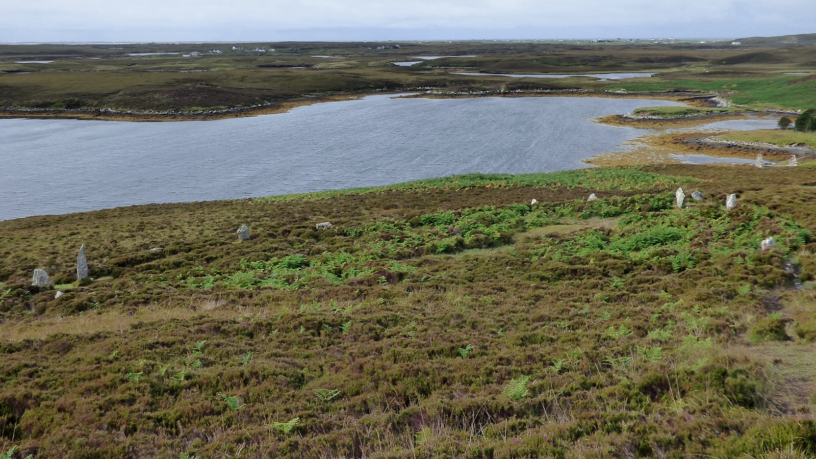
From the cairn, look outward. The valley descends to the east, toward the coast. To the west, the machair stretches toward the Atlantic. The hills of South Uist rise in every direction. Barp Frobost, another Neolithic chambered cairn, stands 1.5 miles to the south on the same meridian line that Somerville documented. The builders of Reineval could see Frobost from where you stand. They intended this.
Sit with the cairn. There is rarely anyone else here. The wind provides the only company, pressing against the stones and against you with equal indifference. Allow the stillness of the monument and the movement of the weather to occupy the same space. This is not a site that asks for hurry. It has waited five thousand years. It can wait for you.
The cairn sits on the northern slope of Beinn Reineabhal at approximately 30 metres above sea level, overlooking Loch na h-Ath Ruaidh and the valley leading down to Mingarry. The entrance passage faces east-southeast. The best-preserved peristalith stones are in the northwest quadrant. The approach from Mingarry comes from the north-northeast.
Reineval Chambered Cairn is understood primarily through its archaeology and its place within the wider Neolithic landscape of South Uist. The absence of formal excavation means that much about the site remains inference, analogy, and educated conjecture.
Reineval is classified as a Hebridean group round chambered cairn, a type defined by Audrey Henshall in her foundational catalogues of Scottish chambered tombs published in 1963 and 1972. Henshall described and planned the site, classifying it alongside other Western Isles cairns that share circular peristaliths, short entrance passages, simple chambers, and prominent hilltop or hillside positions.
The 1998 survey by Vicki Cummings, Cole Henley, and Mike Parker Pearson, conducted as part of the Sheffield Environmental and Archaeological Research Campaign in the Hebrides, confirmed Reineval as one of six classic Hebridean round cairns on South Uist. Their survey produced updated plans and a landscape analysis emphasising the visual relationships between the cairns and their surrounding terrain. They noted that all the South Uist cairns share common architectural features: circular peristaliths of large upright kerb-stones, facades on their southern or eastern sides, funnel-shaped forecourts, and short passages leading to simple chambers sealed by capstones.
The Canmore record (Site 9818) maintained by Historic Environment Scotland provides the most detailed physical description, noting the twelve surviving peristalith stones, the traceable entrance passage on the east-southeast side, the exposed capstone, and the drill holes on certain slabs that indicate later quarrying activity. The cairn dates to the Neolithic period, estimated between 3500 and 3000 BCE, though no radiocarbon dates are available for Reineval specifically. Dating is inferred from the Hebridean passage grave typology and comparison with dated cairns elsewhere in the Western Isles.
No formal excavation has been conducted, so the chamber contents and internal structure remain unknown. This is itself significant: Reineval is one of the few relatively intact Neolithic chambered cairns in Scotland where the sealed deposits may still preserve information about funerary practices, diet, health, and social organisation of the island's earliest farming communities.
No specific Gaelic folklore or oral traditions relating directly to Reineval Chambered Cairn have been documented in the available sources. The local name Barp Reineval preserves a Norse-Gaelic hybrid: 'barp' derives from Old Norse 'borg' or 'berg' meaning mound or cairn, while 'Reineabhal' likely has Norse origins with the suffix '-val' or '-bhal' from Old Norse 'fjall' meaning hill or mountain. These placenames reflect the Norse settlement period in the Outer Hebrides from the ninth to the thirteenth centuries, when Norse-speaking communities imposed their own names on landscape features already old beyond reckoning. The Gaelic-speaking communities who succeeded the Norse would have known the cairn as a fixed feature of their landscape, though whatever stories they told about it have not survived into the written record.
Somerville's early twentieth-century observations of astronomical alignments between Reineval, Barp Frobost, and Askervein have attracted interest from researchers in archaeoastronomy and earth mysteries traditions. The precise meridian alignment of these three sites, combined with orientations to the equinoctial sunrise and winter solstice sunrise, supports interpretations of the Neolithic landscape as a deliberately encoded celestial map. Some researchers view such alignments as evidence of sophisticated cosmological knowledge among Neolithic peoples that mainstream archaeology has been slow to acknowledge. The cairn's commanding hillside position, with views extending in multiple directions, is sometimes interpreted through the lens of earth energy or ley line theories, though these interpretations remain outside the scholarly consensus.
The sealed burial chamber at the heart of Reineval holds the site's deepest mystery. No one in recorded history has opened it, and no formal excavation has been conducted. What lies within is unknown. Human remains, grave goods, the arrangement of the dead, the state of the chamber walls and floor, all remain hidden beneath the capstone and the cairn mound.
The precise date of the cairn's construction is uncertain. The estimated range of 3500 to 3000 BCE is based on typological comparison rather than direct dating. Whether the entrance passage was oriented to the equinoctial sunrise is plausible but unconfirmed. The full original form of the cairn before later quarrying and natural erosion can only be inferred. How Reineval related functionally and ceremonially to the other five round cairns on South Uist, whether they were built by the same community or by neighbouring groups, whether they were in use simultaneously or sequentially, remains an open question. The drill holes on the peristalith and passage slabs suggest later quarrying, but when and by whom is unknown. The identity and daily lives of the people who built and used the cairn, their language, their beliefs, their understanding of death, are beyond recovery from the exterior evidence alone.
Visit planning
Limited accommodation on South Uist. Bed and breakfasts and self-catering cottages are available in Howmore, Daliburgh, and Lochboisdale. The Reineval Accommodation, located nearby on a working croft, offers camping pods and bed and breakfast. Lochboisdale has the Lochboisdale Hotel. Booking in advance is advisable, particularly in summer. Wild camping is permitted under Scottish outdoor access rights.
Respect the scheduled monument. Do not climb on the cairn, remove stones, or dig. Leave no trace. Respect the working farmland on the approach.
Dress for exposed Hebridean moorland in all seasons. Waterproof jacket and overtrousers are essential. Walking boots with ankle support are strongly recommended. The approach track is often muddy and the ground around the cairn is rough, uneven, and covered in heather. Conditions can change rapidly: sun, wind, and rain may alternate within minutes. In summer, midges can be fierce in calm weather, so insect repellent or a head net may be welcome.
Photography is freely permitted and encouraged. The cairn photographs well from multiple angles. The peristalith stones are most dramatic in low-angle light during early morning or late evening. The mound against the Hebridean sky in changing weather provides striking compositions. Aerial and drone photography has produced revealing images of the cairn's circular form, though pilots should check current regulations for the area.
Not traditionally associated with offerings. The cairn asks for nothing beyond respectful attention. Presence and stillness are the appropriate responses. Do not leave objects, flowers, or other materials at the site.
Do not climb on the cairn mound. Do not climb on or lean against the peristalith stones. Do not enter or attempt to clear the passage. Do not dig, probe, or use metal detectors. Do not remove any stones or other material. Do not light fires. Leave no litter. Respect the working farmland on the approach.
Plan your visit
Address
Minngearraidh, Isle of South Uist HS8 5SJ, UK
Hours
Hours, fees, and access can change — verify on the official source before you travel. Practical details last checked Jun 2026.
Nearby sacred places
Sacred places within a half-day’s reach. Pilgrims often visit them together: walk one, stay for the other.

References
Sources consulted when researching this page. Independent verification by readers is welcome.
- 01South Uist, Reineval — Canmore Site 9818 — Historic Environment Scotland / Canmorehigh-reliability
- 02The Neolithic chambered cairns of South Uist (Internet Archaeology 8) — Vicki Cummings, Cole Henley, and Mike Parker Pearsonhigh-reliability
- 03From Machair to Mountains: Archaeological Survey and Excavation in South Uist — Michael Parker Pearson (editor)high-reliability
- 04Reineabhal Chambered Cairn — Visit Outer Hebrides
- 05Reineval Chambered Cairn, South Uist — Britain Express
- 06Orientation of certain megalithic monuments in the south of Scotland (reprint) — Boyle Somerville
- 07Reineval Chambered Tomb — The Modern Antiquarian
- 08Reineval from The Gazetteer for Scotland — The Gazetteer for Scotland
- 09Chambered cairn at Reineabhal — Gordon Hatton / Geograph
Key questions
What pilgrims usually ask
- Why is Reineval Chambered Cairn considered sacred?
- Visit Reineval Chambered Cairn (Barp Reineval) on South Uist, Outer Hebrides. A 5,000-year-old Neolithic passage grave with massive standing stones on open moor
- What should I wear at Reineval Chambered Cairn?
- Dress for exposed Hebridean moorland in all seasons. Waterproof jacket and overtrousers are essential. Walking boots with ankle support are strongly recommended. The approach track is often muddy and the ground around the cairn is rough, uneven, and covered in heather. Conditions can change rapidly: sun, wind, and rain may alternate within minutes. In summer, midges can be fierce in calm weather, so insect repellent or a head net may be welcome.
- Can I take photos at Reineval Chambered Cairn?
- Photography is freely permitted and encouraged. The cairn photographs well from multiple angles. The peristalith stones are most dramatic in low-angle light during early morning or late evening. The mound against the Hebridean sky in changing weather provides striking compositions. Aerial and drone photography has produced revealing images of the cairn's circular form, though pilots should check current regulations for the area.
- How long should I spend at Reineval Chambered Cairn?
- 1 to 1.5 hours including the approach, a full circumnavigation, time at the passage entrance, and contemplation
- What offerings are appropriate at Reineval Chambered Cairn?
- Not traditionally associated with offerings. The cairn asks for nothing beyond respectful attention. Presence and stillness are the appropriate responses. Do not leave objects, flowers, or other materials at the site.
- What etiquette should visitors follow at Reineval Chambered Cairn?
- Respect the scheduled monument. Do not climb on the cairn, remove stones, or dig. Leave no trace. Respect the working farmland on the approach.
- What is the history of Reineval Chambered Cairn?
- Sometime between 3500 and 3000 BCE, the Neolithic farming communities of South Uist began constructing monumental chambered cairns on prominent hillsides across the island. These were among the earliest permanent settlers of the Outer Hebrides, people who had brought domesticated crops and livestock to the islands and who now possessed the social cohesion and surplus labor required for monumental building. Reineval was one of six round cairns they built on South Uist, each sharing a distinctive architectural vocabulary. Large stone slabs, some nearly two metres long, were transported uphill and stood upright to form a circular peristalith. A facade was constructed on the eastern side, creating a funnel-shaped forecourt that funnelled approach toward the entrance passage. The passage, barely a metre wide, led inward to a central chamber where the dead were placed. A massive capstone sealed the chamber. The cairn mound was built up around and over the entire structure, rising to nearly four metres in height and over twenty metres in diameter. The cairn was not an isolated monument. All six round cairns on South Uist share common features and occupy prominent landscape positions with extensive views. Boyle Somerville, a Vice-Admiral and amateur archaeologist working in the early twentieth century, documented that Reineval, Barp Frobost to the south, and Askervein further south again lie on a precise north-south meridian line. He noted orientations to the equinoctial sunrise and winter solstice sunrise, suggesting that the placement of these burial monuments encoded astronomical relationships that connected the cycle of death with the cycle of the sun. The cairn was built to last, and it has lasted. No formal excavation has ever been conducted, so the chamber contents remain unknown. The monument stands on its hillside essentially as the last Neolithic users left it, weathered by five millennia of Hebridean weather but structurally intact. The dead within, if they remain, have lain undisturbed in darkness for longer than any written history records.
- Who is associated with Reineval Chambered Cairn?
- Audrey Henshall, Boyle Somerville, Vicki Cummings, Mike Parker Pearson