Parque Nacional Cavernas do Peruaçu
Twelve thousand years of human mark-making inside the earth itself
Januária, Brazil
Plan this visit
Practical context before you go
A single guided cave tour takes half a day to a full day depending on the route. To visit multiple caves and viewpoints within the park, plan for two to three days. This is not a site that rewards rushing. The distances between cave sites, the pace of guided tours, and the physical demands of the terrain all argue for allowing more time rather than less.
The park spans the municipalities of Januaria, Itacarambi, and Sao Joao das Missoes in northern Minas Gerais state. Januaria is the nearest city and the primary base for visitors. Advance booking is required through ICMBio at cavernas.peruacu@icmbio.gov.br. Accredited environmental conductors must be hired: one conductor per eight visitors for most areas, one per five visitors at Lapa Bonita and Arco do Andre. Negotiate conductor pricing before your visit. Mobile phone signal is unreliable within the park. For emergencies, the nearest reliable signal and services are in Januaria. No specific information on seasonal closure dates was available at time of writing; check with ICMBio for current access arrangements before planning your trip.
All visits require advance booking and mandatory guided tours with accredited conductors. The primary etiquette here is one of preservation: protect the caves, respect the archaeological record, and follow your guide's instructions without exception. The Xakriaba indigenous connection to this landscape also warrants respectful awareness.
At a glance
- Coordinates
- -15.1111, -44.2431
- Type
- Cave Art Site
- Suggested duration
- A single guided cave tour takes half a day to a full day depending on the route. To visit multiple caves and viewpoints within the park, plan for two to three days. This is not a site that rewards rushing. The distances between cave sites, the pace of guided tours, and the physical demands of the terrain all argue for allowing more time rather than less.
- Access
- The park spans the municipalities of Januaria, Itacarambi, and Sao Joao das Missoes in northern Minas Gerais state. Januaria is the nearest city and the primary base for visitors. Advance booking is required through ICMBio at cavernas.peruacu@icmbio.gov.br. Accredited environmental conductors must be hired: one conductor per eight visitors for most areas, one per five visitors at Lapa Bonita and Arco do Andre. Negotiate conductor pricing before your visit. Mobile phone signal is unreliable within the park. For emergencies, the nearest reliable signal and services are in Januaria. No specific information on seasonal closure dates was available at time of writing; check with ICMBio for current access arrangements before planning your trip.
Pilgrim tips
- Long pants and long-sleeved shirts are not optional but essential. The sand flies that transmit Leishmaniasis are present throughout the park, and exposed skin is an invitation for bites. Sturdy hiking shoes with good grip are required for the trails and cave interiors, which can be uneven and wet. Sun protection is needed for exposed sections between caves. Bring a hat and sunscreen.
- Personal photography is permitted during guided tours. Flash restrictions may apply in certain caves to protect rock art; follow your conductor's instructions. Remember that the most meaningful encounters with prehistoric art often happen when the camera stays in the bag. Observe first. Photograph second, if at all.
- Do not touch any cave formation or rock art surface. The oils from human skin cause cumulative damage to both geological and painted surfaces. Follow your guide's instructions exactly regarding where to stand and which paths to use. The caves contain fragile formations that have developed over millions of years and archaeological deposits that have not yet been fully studied. Apply insect repellent generously and wear covering clothing. The sand flies in this region carry Leishmaniasis, a serious disease. This is not an abstract precaution but a genuine health concern that the park's remoteness makes more consequential.
Overview
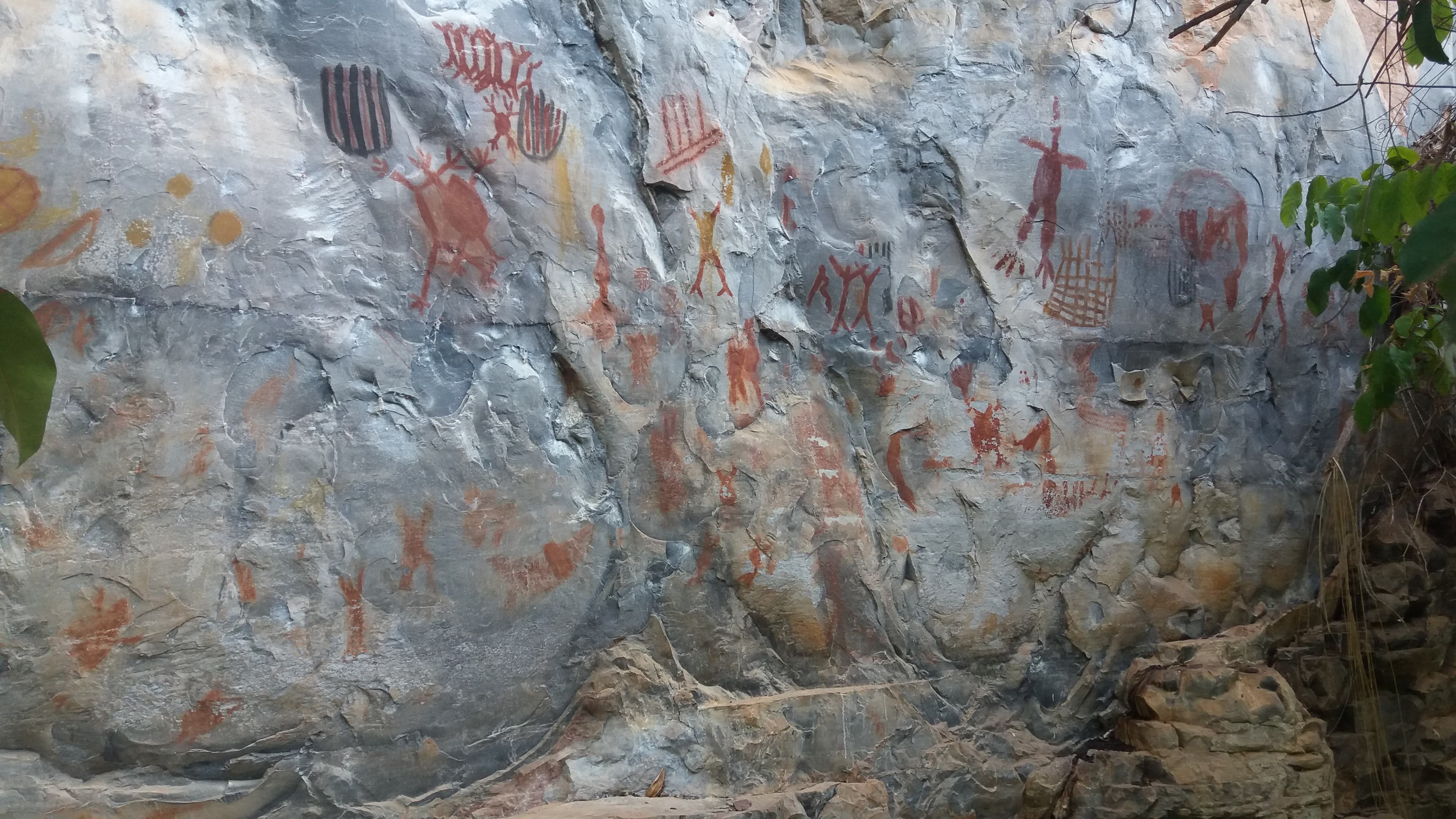
In the limestone canyons of northern Minas Gerais, more than 3,000 prehistoric paintings cover the walls of caves that reach cathedral heights. Parque Nacional Cavernas do Peruacu preserves one of South America's most significant prehistoric cultural landscapes, where successive human communities painted, buried their dead, and stored food for over ten millennia. The Xakriaba people, who gave this valley its name, maintain a living connection to the land.
Descend into the Peruacu valley and you enter a different order of time. The limestone here was laid down by an ancient sea. The river carved through it over millions of years, collapsing roofs to expose passages a hundred meters high, shaping chambers that dwarf any human architecture. Into these spaces, beginning perhaps twelve thousand years ago, people brought pigment and purpose.
The paintings they left number in the thousands. Red and black figures cover sheltered walls and cave entrances: hunting scenes, geometric patterns, ceremonial gatherings, representations of the animals that shared this landscape. Multiple artistic traditions overlap, the work of successive cultures who returned to the same surfaces across millennia. At Lapa do Boquete, excavations have uncovered stone tools dating to twelve thousand years ago, burials from seven thousand years ago, and a prehistoric food storage silo that speaks to sustained community life.
The Xakriaba people, whose reserve borders the park, named this place Peruacu. The word is interpreted as either 'big hole' or from peru (fissure) and acu (great) in their language. Either way, it acknowledges what the landscape announces on its own terms: something vast has opened in the earth here. In 2025, UNESCO inscribed the site as a World Heritage property, recognizing what the rock and the paintings and the Xakriaba have known far longer.
Context and lineage
The story begins with an ancient sea. Millions of years ago, much of what is now the Brazilian interior lay beneath ocean, and the sediments that settled on its floor compressed into the limestone massifs that define the Peruacu landscape today. When the sea retreated and the Peruacu River established its course, it began dissolving and carving through this limestone, creating an underground passage system of extraordinary dimensions. At six major points, the roof collapsed, exposing the river's subterranean channel and creating the monumental cave openings visible today.
Humans arrived in this landscape at least twelve thousand years ago. The earliest evidence comes from stone tools excavated at Lapa do Boquete. Over the following millennia, successive cultures made use of the caves for shelter, burial, food storage, and the creation of rock art. More than eighty archaeological sites have been documented within the park, containing over three thousand paintings in multiple styles that indicate different cultural traditions or evolving practices within continuous populations.
The Xakriaba people, documented in the region since at least the sixteenth century, gave the valley its name and have maintained their relationship with the landscape through centuries of colonial disruption. Their reserve borders the national park, and their ecological knowledge has contributed to the conservation of the broader region.
Formal protection came in 1999, when Brazil established the national park under the administration of ICMBio. The site had been on UNESCO's Tentative List since 1998, and in 2025 it achieved World Heritage inscription as the Peruacu River Canyon, recognized under criteria for outstanding natural beauty and geological significance. It became Brazil's twenty-fifth World Heritage Site.
The cultural lineage of the Peruacu valley is long and only partially legible. Stone tools at Lapa do Boquete date human presence to twelve thousand years ago. The rock art traditions that followed span multiple styles and periods, with some sources dating the oldest paintings to nine thousand years ago. Burials at Lapa do Boquete from approximately seven thousand years ago, found alongside stone tools and evidence of food storage, indicate organized community life with ritual dimensions.
Whether these successive cultures represent distinct populations or evolving traditions within continuous communities remains an open question. The coexistence of multiple rock art styles in the same shelters suggests either cultural succession or deliberate layering by communities aware of their predecessors' work. In either case, the impulse to mark these particular surfaces persisted for millennia.
The Xakriaba represent the most recent link in this chain. Their relationship with the landscape is not archaeological but ongoing. The park's administrative structure, which coordinates with the Xakriaba community, attempts to honor this continuity, though the tensions between indigenous sovereignty and federal conservation management are real and unresolved.
The prehistoric painters of Peruacu
original creators
Multiple successive cultures spanning approximately twelve thousand years who created over three thousand paintings in caves and shelters throughout the valley. Their identities and social organizations remain unknown, but their artistic traditions, ranging from naturalistic depictions of animals and humans to highly stylized geometric designs, constitute one of the most significant rock art concentrations in South America.
The Xakriaba
indigenous stewards
The indigenous people who have inhabited the Peruacu region since at least the sixteenth century and who gave the valley its name. Their reserve borders the national park, and their traditional ecological knowledge and land stewardship practices contribute to the conservation of the landscape. They represent a living cultural connection to the valley that predates and outlasts the bureaucratic frameworks of park management.
ICMBio (Instituto Chico Mendes de Conservacao da Biodiversidade)
conservation steward
The Brazilian federal agency responsible for managing the national park since its establishment. Named after Chico Mendes, the rubber tapper and environmental activist whose murder in 1988 galvanized the Brazilian conservation movement, ICMBio administers access, coordinates research, and works with accredited local conductors to manage visitor experience.
UNESCO / IUCN advisory body
heritage evaluation
The advisory body whose evaluation led to the 2025 World Heritage inscription, documenting the site's outstanding universal value for both its geological formations, described as the most extraordinary documented example of fluvial karstification in the world, and its natural beauty.
Why this place is sacred
Several forces converge here. The first is geological: the Peruacu River carved an underground path through limestone, and at six major points the roof has collapsed, exposing the river's subterranean course. These collapses created cave passages of extraordinary scale. Gruta do Janelao reaches a hundred meters in height and sixty meters in width. The stalactite known as Perna da Bailarina, the Dancer's Leg, hangs twenty-eight meters from the ceiling and is considered the largest in the world. These are not intimate spaces. They are earth-cathedrals, formed not by human intention but by water and time.
The second force is human. For at least twelve thousand years, people were drawn to these caves. They painted the walls with images whose full meaning remains unknown. They buried their dead here. They stored food in purpose-built chambers underground. The consistency of this attention across millennia, from cultures that may have had no direct continuity with one another, suggests the caves possess a quality that different peoples in different eras recognized and responded to.
The third force is ecological. The park sits at the convergence of the Cerrado, Caatinga, and Atlantic Forest biomes. This is not merely a geological or archaeological site but a place of exceptional biological diversity, where the living surface world meets the mineral underworld through the river's passage between light and darkness.
What makes the valley thin, in the sense this word carries for seekers, is the simultaneity. Standing in Gruta do Janelao, you are inside formations that took millions of years to create, looking at paintings made by hands that have been dust for millennia, listening to an underground river that continues its work indifferent to all human timescales. The ordinary boundaries between past and present, surface and depth, human time and deep time, become less certain here.
The caves served multiple functions across their long history of human use. Evidence from Lapa do Boquete and other excavated sites indicates habitation, burial, food storage, and the creation of elaborate rock art. The presence of formalized burial practices alongside artistic traditions that persisted for thousands of years suggests purposes beyond mere shelter. Whether the painting itself constituted a ritual act, or whether the paintings marked spaces already held as significant, scholars continue to investigate. What seems clear is that these caves were not simply convenient places to live. They were chosen, returned to, and marked with care across deep time.
For millennia the caves were part of a living cultural landscape, used and painted by successive communities. The arrival of Portuguese colonizers and the displacement of indigenous peoples disrupted this continuity. The Xakriaba, who have inhabited the region since at least the sixteenth century, maintained their connection to the land even as their territory was reduced and their autonomy threatened.
In 1999, the Brazilian government established the national park, placing the caves under federal protection administered by ICMBio. The 2025 UNESCO inscription as the Peruacu River Canyon, under criteria recognizing outstanding natural beauty and geological significance, brought international visibility. The park now exists in a dual state: a protected archaeological and natural heritage site, and a landscape with a living indigenous connection that predates and outlasts the bureaucratic frameworks overlaid upon it.
Traditions and practice
The rock art offers partial windows into practices that can only be inferred. Painted scenes depict what appear to be communal gatherings, hunting events, and ceremonial activities. The presence of burials at Lapa do Boquete, with skeletal remains dating to approximately seven thousand years ago found alongside stone tools, suggests formalized funerary practices. A prehistoric food storage silo discovered at the same site indicates organized community life in which the caves played a central, sustained role. The red and black pigments used in the paintings were deliberately prepared and applied with evident care, suggesting that the act of painting may itself have carried ritual significance.
The specific ceremonies, beliefs, and intentions behind these practices remain unknown. Multiple artistic traditions coexist in the valley, and whether they represent different ritual systems or evolving expressions within continuous cultures is a question that the archaeological record, as yet, cannot fully answer.
The Xakriaba people maintain cultural practices on their adjacent reserve, though specific contemporary spiritual ceremonies at the caves themselves are not well documented in public sources. This absence in the public record may reflect the privacy of indigenous knowledge as much as any discontinuation of practice. The park administration coordinates with the Xakriaba community, and their traditional ecological knowledge contributes to conservation of the broader landscape.
Enter the caves as though entering something alive. The guided format requires this anyway: you move at the conductor's pace, not your own, and this imposed slowness is a gift rather than a constraint.
In Gruta do Janelao, after the initial response to the scale of the space, let your eyes adjust. Look up at the ceiling formations, then down at the river far below. Notice how sound behaves here: how voices echo and distort, how the dripping water creates a rhythm that has continued for longer than any human civilization. Stand still for a full minute and attend to what the silence between the drips contains.
At the rock art sites, resist the impulse to photograph immediately. Look first at the full surface, then narrow your focus to individual figures. Notice the care with which pigment was applied. Consider the hands that made these marks: their steadiness, their intention, their understanding of the surface they were working with. These painters knew this stone intimately. They chose where to place each figure.
When the guide pauses at Lapa do Boquete and describes the burials found here, let the information settle physically. You are standing where people buried their dead seven thousand years ago. They chose this place. Whatever their reasons, the act of burial implies belief in significance beyond the practical, a recognition that some places matter more than others for the threshold between life and what follows.
If the morning light reaches a cave entrance during your visit, watch how it falls across the painted surfaces. The painters may have worked by firelight, but they would have known how sunlight moved across these walls. Some placement of figures appears responsive to how light reveals them at particular hours.
Prehistoric Rock Art Traditions of the Peruacu Valley
HistoricalThe Peruacu valley contains one of Brazil's most important concentrations of prehistoric rock art, with over three thousand paintings across more than eighty archaeological sites. The art spans multiple cultural periods from approximately twelve thousand years ago to the contact period. Multiple distinct styles coexist, from naturalistic depictions of animals and humans engaged in hunting and ceremonial activity to highly stylized geometric designs, indicating successive cultural traditions that returned to the same sacred surfaces across deep time.
The caves were used for habitation, burial, food storage, and the creation of elaborate paintings in red and black pigments. At Lapa do Boquete, burials dating to approximately seven thousand years ago, stone tools from twelve thousand years ago, and a prehistoric food silo indicate sustained community engagement with the caves. The consistent use of these spaces over millennia, combined with burial evidence, suggests ritual and ceremonial purposes that transcended mere shelter.
Xakriaba Indigenous Connection
ActiveThe Xakriaba people have inhabited the Peruacu region since at least the sixteenth century and maintain a living cultural connection to the landscape. They named the valley, and their reserve borders the national park. Their relationship with this land represents a continuity of indigenous presence that links the contemporary moment to the deep past of the valley, even if direct cultural descent from the prehistoric painters cannot be established.
Contemporary Xakriaba practices at the caves specifically are not well documented in publicly available sources. Their traditional land stewardship and ecological knowledge contribute to conservation of the broader landscape. The park administration coordinates with the Xakriaba community, and their ongoing presence as neighbors and stewards of the valley represents an active, living tradition of relationship with the land.
Archaeological and Conservation Stewardship
ActiveSince the park's establishment in 1999 and particularly since the 2025 UNESCO inscription, an active tradition of archaeological research, geological study, and conservation management has developed around the Peruacu caves. ICMBio administers the park, accredited conductors guide visitors, and ongoing excavation and documentation continue to expand understanding of the site's significance.
Systematic archaeological excavation at sites including Lapa do Boquete has yielded stone tools, burial remains, and food storage evidence. Conservation efforts focus on protecting both geological formations and painted surfaces from environmental degradation and visitor impact. The accredited conductor program trains local guides to interpret the site's geological, archaeological, and ecological significance, creating a mediated visitor experience that serves both education and preservation.
Experience and perspectives
The first thing the caves teach is scale. Entering Gruta do Janelao, where the ceiling rises a hundred meters overhead and the underground river murmurs below, the body registers its own smallness before the mind catches up. This is not the smallness of intimidation but of perspective: a recalibration of your sense of where you stand in the order of things. Visitors describe this as physical, felt in the chest and the legs before it becomes a thought.
Then the paintings. After the immensity of the cave architecture, the rock art arrives as something intensely intimate. These marks were made by specific hands. Red and black pigments applied to stone by people whose names and languages are lost, whose world we cannot reconstruct, but whose impulse to make meaning from experience is instantly recognizable. Visitors report a quality of connection that transcends the usual museum distance from ancient artifacts. The paintings are still in the place they were made, on the surfaces their creators chose. There is no glass case between you and them, only the instruction not to touch.
The remoteness contributes to the experience. Peruacu is not on the standard tourist circuit. Northern Minas Gerais is far from Rio and Sao Paulo, and the park's location requires intention to reach. Those who arrive have made an effort, and the effort functions as a kind of threshold-crossing. The mandatory guided tours, led by accredited local conductors, add an element of mediation that focuses attention. You cannot wander here alone, clicking a camera. Someone is interpreting the site for you, drawing your eye to what you might miss, providing context that transforms marks on stone into traces of human lives.
Several visitors describe a particular quality of silence inside the caves. Not the absence of sound, since the river and the dripping of water provide a constant backdrop, but a listening quality. The caves seem to absorb and hold sound differently. Your own breathing and footsteps become prominent. In the deeper chambers, away from the cave mouths where light enters, the darkness has a texture that photographs cannot convey.
Come prepared for physical engagement. The trails within the park require hiking, and the caves demand attention to footing on uneven, sometimes wet surfaces. Wear long pants and long sleeves regardless of heat: the sand flies in this region transmit Leishmaniasis, and insect repellent alone is insufficient protection.
Bring water and food, as facilities within the park are minimal. But also bring willingness to be slow. The guides know these caves intimately, and the quality of your experience depends in part on your willingness to listen rather than lead. When the guide pauses, pause. When they point out a painting, look for longer than you think necessary. The rock art reveals itself in layers. What first appears as simple marks becomes, with sustained attention, a record of observation so careful it amounts to devotion.
The Peruacu valley invites interpretation from multiple directions, and each reveals something the others miss. Archaeological science reads the material record. Indigenous knowledge holds the relationship between people and land. Conservation biology sees the living ecosystem. The contemplative visitor encounters all of these at once, layered in a single landscape that resists reduction to any single framework.
Archaeologists and geologists recognize the Peruacu valley as one of Brazil's most significant prehistoric cultural and natural landscapes. The cave systems represent what the UNESCO advisory body described as the most extraordinary documented example of fluvial karstification in the world: six major collapse points exposing sections of an underground river that formed passages up to a hundred meters high and sixty meters wide.
The rock art, spanning multiple styles and periods, provides evidence of successive cultural occupations from approximately twelve thousand years ago to the contact period. Excavations at Lapa do Boquete have yielded stone tools, burials, and evidence of food storage, establishing it as one of the region's most extensively studied archaeological sites. The coexistence of multiple artistic traditions in the same shelters raises important questions about cultural continuity and succession that remain under active investigation.
The 2025 UNESCO inscription under criteria for natural beauty and geological significance confirmed the site's outstanding universal value, though some scholars note that the cultural and archaeological dimensions, which were part of the original tentative list submission, were not included in the final inscription criteria. The tension between the site's natural and cultural significance continues to shape how it is interpreted and managed.
The Xakriaba people maintain a cultural and spiritual connection to the Peruacu landscape that predates the park, the nation-state, and the colonial encounter. Their traditional ecological knowledge has contributed to the conservation of the region, and their presence as neighbors and stewards of the landscape represents a living relationship with the land that academic research can document but not fully capture.
Specific Xakriaba spiritual interpretations of the cave paintings are not widely available in public academic or tourism sources. This absence may reflect the privacy of indigenous knowledge, gaps in ethnographic research, or the simple fact that sacred knowledge is not always meant for publication. What is documented is a people's sustained relationship with a place, expressed through naming, through stewardship, through continued presence on the land despite centuries of pressure to leave.
Genuine mysteries pervade this site. The specific cultural identity of the peoples who created the rock paintings remains unknown, as does the social organization that sustained artistic production across millennia. The relationship between the different rock art traditions, whether they represent distinct cultural groups or evolving practices within continuous populations, is unresolved. The full meaning and cultural context of the paintings themselves, beyond the basic identification of figures, remains under scholarly investigation.
The ceremonial or spiritual significance of the burial practices at Lapa do Boquete is inferred from context but cannot be stated with confidence. Many of the park's approximately one hundred and eighty caves have not been fully excavated, meaning that the archaeological record as currently understood represents only a fraction of what the valley contains. Each new excavation has the potential to rewrite the story.
Visit planning
The park spans the municipalities of Januaria, Itacarambi, and Sao Joao das Missoes in northern Minas Gerais state. Januaria is the nearest city and the primary base for visitors. Advance booking is required through ICMBio at cavernas.peruacu@icmbio.gov.br. Accredited environmental conductors must be hired: one conductor per eight visitors for most areas, one per five visitors at Lapa Bonita and Arco do Andre. Negotiate conductor pricing before your visit. Mobile phone signal is unreliable within the park. For emergencies, the nearest reliable signal and services are in Januaria. No specific information on seasonal closure dates was available at time of writing; check with ICMBio for current access arrangements before planning your trip.
Januaria serves as the main base town, offering accommodation, restaurants, and services. Facilities within the park itself are limited. Plan to carry water, food, and any supplies you need for the day. Arrange conductor services and logistics from Januaria before entering the park.
All visits require advance booking and mandatory guided tours with accredited conductors. The primary etiquette here is one of preservation: protect the caves, respect the archaeological record, and follow your guide's instructions without exception. The Xakriaba indigenous connection to this landscape also warrants respectful awareness.
Long pants and long-sleeved shirts are not optional but essential. The sand flies that transmit Leishmaniasis are present throughout the park, and exposed skin is an invitation for bites. Sturdy hiking shoes with good grip are required for the trails and cave interiors, which can be uneven and wet. Sun protection is needed for exposed sections between caves. Bring a hat and sunscreen.
Personal photography is permitted during guided tours. Flash restrictions may apply in certain caves to protect rock art; follow your conductor's instructions. Remember that the most meaningful encounters with prehistoric art often happen when the camera stays in the bag. Observe first. Photograph second, if at all.
No ritual offerings should be left in the caves. The park is a protected conservation unit and any materials left behind are treated as litter. If you wish to honor the place, do so through attention, silence, and the care with which you move through it.
All visits require advance booking via cavernas.peruacu@icmbio.gov.br. No unaccompanied access is permitted under any circumstances. Accredited conductors must be hired: one per eight visitors in general, one per five at Lapa Bonita and Arco do Andre. Children under five are not counted toward group formation at Arco do Andre. No touching of cave formations or rock art. No removal of any natural or archaeological material. Bring sufficient water and food, as facilities within the park are limited.
Plan your visit
Address
155 - BR-135, s/n - Fabião I, Januária - MG, 39480-000, Brazil
Hours
Hours, fees, and access can change — verify on the official source before you travel. Practical details last checked Jun 2026.
Nearby sacred places
Sacred places within a half-day’s reach. Pilgrims often visit them together: walk one, stay for the other.

Bom Jesus da Lapa, Santuário do Bom Jesus da Lapa
Bom Jesus da Lapa, Bahia, Brazil
224.2 km away
Santuário do Caraça
Catas Altas, Minas Gerais, Brazil
560.2 km away

Trinidade, Basilica of Trindade, Divino Pai Eterno
Trindade, Goiás, Brazil
586.5 km away
Sanctuary of Bom Jesus do Congonhas
Congonhas, Minas Gerais, Brazil
601.5 km away
References
Sources consulted when researching this page. Independent verification by readers is welcome.
- 01Peruaçu River Canyon - UNESCO World Heritage Centre — UNESCO World Heritage Centrehigh-reliability
- 02Cavernas do Peruaçu Federal Environmental Protection Area (APA) / Veredas Do Peruaçu State Park - UNESCO Tentative List — UNESCO World Heritage Centrehigh-reliability
- 03Informações Sobre Visitação - PARNA Cavernas do Peruaçu — Instituto Chico Mendes de Conservação da Biodiversidade (ICMBio)high-reliability
- 04PARNA Cavernas do Peruaçu - Conservation Areas in Brazil — Instituto Socioambientalhigh-reliability
- 05LATIN AMERICA / CARIBBEAN - Cavernas do Peruaçu National Park Brazil (Advisory Body Evaluation) — UNESCO / IUCNhigh-reliability
- 06Cavernas do Peruaçu National Park - Wikipedia — Wikipedia contributors
- 07Cavernas do Peruaçu National Park: Brazil's UNESCO World Heritage of Caves and Rock Art — Soul Brasil Magazine
- 08Exploring Brazil's Peruaçu River Canyon — LAC Geo
- 09Peruaçu Caves in Brazil recognized as UNESCO World Heritage Site — MercoPress
- 10Peruaçu Caves: Brazil's Newest World Heritage Wonder — Brazilcore
Key questions
What pilgrims usually ask
- Why is Parque Nacional Cavernas do Peruaçu considered sacred?
- Explore Peruacu's ancient caves, 3,000+ prehistoric paintings, and cathedral-scale limestone formations in Brazil's newest UNESCO World Heritage Site.
- What should I wear at Parque Nacional Cavernas do Peruaçu?
- Long pants and long-sleeved shirts are not optional but essential. The sand flies that transmit Leishmaniasis are present throughout the park, and exposed skin is an invitation for bites. Sturdy hiking shoes with good grip are required for the trails and cave interiors, which can be uneven and wet. Sun protection is needed for exposed sections between caves. Bring a hat and sunscreen.
- Can I take photos at Parque Nacional Cavernas do Peruaçu?
- Personal photography is permitted during guided tours. Flash restrictions may apply in certain caves to protect rock art; follow your conductor's instructions. Remember that the most meaningful encounters with prehistoric art often happen when the camera stays in the bag. Observe first. Photograph second, if at all.
- How long should I spend at Parque Nacional Cavernas do Peruaçu?
- A single guided cave tour takes half a day to a full day depending on the route. To visit multiple caves and viewpoints within the park, plan for two to three days. This is not a site that rewards rushing. The distances between cave sites, the pace of guided tours, and the physical demands of the terrain all argue for allowing more time rather than less.
- How do you visit Parque Nacional Cavernas do Peruaçu?
- The park spans the municipalities of Januaria, Itacarambi, and Sao Joao das Missoes in northern Minas Gerais state. Januaria is the nearest city and the primary base for visitors. Advance booking is required through ICMBio at cavernas.peruacu@icmbio.gov.br. Accredited environmental conductors must be hired: one conductor per eight visitors for most areas, one per five visitors at Lapa Bonita and Arco do Andre. Negotiate conductor pricing before your visit. Mobile phone signal is unreliable within the park. For emergencies, the nearest reliable signal and services are in Januaria. No specific information on seasonal closure dates was available at time of writing; check with ICMBio for current access arrangements before planning your trip.
- What offerings are appropriate at Parque Nacional Cavernas do Peruaçu?
- No ritual offerings should be left in the caves. The park is a protected conservation unit and any materials left behind are treated as litter. If you wish to honor the place, do so through attention, silence, and the care with which you move through it.
- What etiquette should visitors follow at Parque Nacional Cavernas do Peruaçu?
- All visits require advance booking and mandatory guided tours with accredited conductors. The primary etiquette here is one of preservation: protect the caves, respect the archaeological record, and follow your guide's instructions without exception. The Xakriaba indigenous connection to this landscape also warrants respectful awareness.
- What is the history of Parque Nacional Cavernas do Peruaçu?
- The story begins with an ancient sea. Millions of years ago, much of what is now the Brazilian interior lay beneath ocean, and the sediments that settled on its floor compressed into the limestone massifs that define the Peruacu landscape today. When the sea retreated and the Peruacu River established its course, it began dissolving and carving through this limestone, creating an underground passage system of extraordinary dimensions. At six major points, the roof collapsed, exposing the river's subterranean channel and creating the monumental cave openings visible today. Humans arrived in this landscape at least twelve thousand years ago. The earliest evidence comes from stone tools excavated at Lapa do Boquete. Over the following millennia, successive cultures made use of the caves for shelter, burial, food storage, and the creation of rock art. More than eighty archaeological sites have been documented within the park, containing over three thousand paintings in multiple styles that indicate different cultural traditions or evolving practices within continuous populations. The Xakriaba people, documented in the region since at least the sixteenth century, gave the valley its name and have maintained their relationship with the landscape through centuries of colonial disruption. Their reserve borders the national park, and their ecological knowledge has contributed to the conservation of the broader region. Formal protection came in 1999, when Brazil established the national park under the administration of ICMBio. The site had been on UNESCO's Tentative List since 1998, and in 2025 it achieved World Heritage inscription as the Peruacu River Canyon, recognized under criteria for outstanding natural beauty and geological significance. It became Brazil's twenty-fifth World Heritage Site.