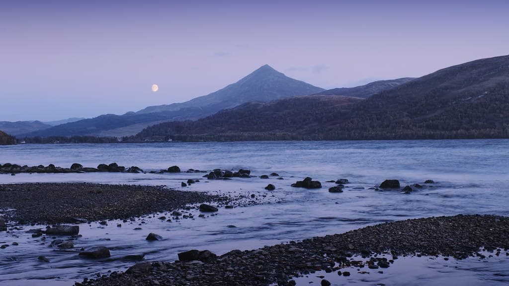
Mount Schiehallion, Scotland
The Fairy Hill of the Caledonians, where Celtic Otherworld meets Highland stone
Aberfeldy, Alba / Scotland, United Kingdom
Plan this visit
Practical context before you go
5-6 hours allowing time for summit contemplation
Schiehallion requires practical respect for the mountain environment and cultural respect for its traditions. Stay on designated paths to protect fragile habitat. Do not leave offerings that could harm wildlife or the landscape. Approach with awareness that this is ground humans have considered sacred for millennia.
At a glance
- Coordinates
- 56.6669, -4.1003
- Type
- Sacred Mountain
- Suggested duration
- 5-6 hours allowing time for summit contemplation
Pilgrim tips
- No spiritual requirements. Appropriate hillwalking gear is essential: sturdy waterproof boots, warm and waterproof layers, hat and gloves. Scottish mountain weather shifts without warning. Even in summer, conditions can deteriorate rapidly.
- Photography is welcomed. Be mindful of others seeking solitude, particularly on the summit. If you encounter individuals engaged in contemplative practice, give them space.
- The mountain demands respect in practical terms. Weather changes rapidly in the Scottish Highlands. The boulder field summit requires careful navigation. Winter conditions require ice-axe and crampons and mountaineering experience. Do not attempt the climb in poor weather without appropriate preparation.
Overview
Rising like a sentinel at the heart of Scotland, Schiehallion carries one of the most evocative names in Gaelic geography: Sidh Chailleann, the Fairy Hill of the Caledonians. For millennia, this quartzite peak has been understood as a dwelling place of the aos sidhe, the people of peace who live within hollow hills. Caves on its southern slopes were once believed to open into the Otherworld itself. Today, seekers still climb to honour traditions that may stretch unbroken from the Iron Age.
There is something about Schiehallion that stops people mid-stride. Viewed from the east or west, the mountain rises in an almost perfect cone, isolated against the Highland sky in a way that seems intentional, chosen. The Caledonians who named it—the tribal confederacy of pre-Roman Scotland—saw a dwelling place of spirits. The name they gave it has survived over two thousand years: Sidh Chailleann, the Fairy Hill of their people.
The Gaelic word sidh carries weight that the English 'fairy' fails to convey. These were not the diminutive sprites of Victorian imagination but powerful beings dwelling within the earth, the aos sidhe or 'people of peace.' Some scholars suggest sidh should be translated as 'ancestor spirits,' making Schiehallion the Hill of the Ancestors of the Caledonians. Either translation points to the same understanding: this mountain marks a threshold between worlds.
Caves along the southern slopes reinforce this threshold quality. The longest, Uamh Tom a' Mhor-fhir—Cave of the Hillock of the Great Man—extends over forty metres into darkness. Folk accounts describe doors within that open and close of their own accord, chambers that stretch from one side of the mountain to the other. Whether these stories are literal or symbolic, they map the same territory: an entrance to realms not visible on the surface.
Schiehallion stands near Scotland's geographic centre, visible from great distances in every direction. Some have called it Scotland's axis mundi, the pivot around which sacred geography turns. Whether such claims can be verified matters less than what they reveal: people have long sensed that this mountain holds more than geology can measure.
Context and lineage
No founding narrative exists for Schiehallion's sacredness—the mountain predates such stories. What survives is a name: Sidh Chailleann, Fairy Hill of the Caledonians. The Caledonians were the Brittonic-speaking tribal confederacy that gave Scotland its name (Caledonia) and resisted Roman incursion. Their presence is confirmed by nearby Dunkeld—Dun Chailleann, Fort of the Caledonians—which shares Schiehallion's etymological root.
The folklore that accumulated around the mountain tells of the aos sidhe dwelling within, of Queen Mab in green silk robes presiding over annual gatherings of fairy tribes, of the Cailleach Bheur riding storms from its summit to deal icy death to winter travellers. These stories cannot be dated precisely, but they speak to continuous recognition of the mountain as a place of power.
In 1774, the mountain entered scientific history when Astronomer Royal Nevil Maskelyne conducted an experiment to measure Earth's density by observing how the mountain's mass deflected a plumb line. The site was chosen by Charles Mason—of Mason-Dixon Line fame—for its isolation and regular shape. The experiment succeeded, and mathematician Charles Hutton, analysing the survey data, invented contour lines to represent terrain. Schiehallion thus holds an unexpected place in the history of cartography.
Schiehallion's lineage is not one of institutions but of continuous human recognition. The Caledonians named it. Medieval Scots feared and revered it. Enlightenment scientists measured it. Contemporary seekers climb it. No single tradition has ever owned the mountain; instead, successive generations have added their understanding to layers already present. The John Muir Trust now holds the eastern slopes in conservation, ensuring the landscape remains accessible to those who come seeking whatever they seek.
Nevil Maskelyne
historical
Astronomer Royal who conducted the 1774 'Schiehallion Experiment' to measure Earth's density. Won the Royal Society's Copley Medal for this work.
Charles Hutton
historical
Mathematician who invented contour lines while analysing Maskelyne's Schiehallion survey data. Published findings in 1778.
The Cailleach Bheur
mythological
The Blue Hag, ancient winter goddess who haunts Schiehallion and rides storms from its summit. Represents the personification of winter in Gaelic tradition.
Why this place is sacred
The Celtic world was never a single plane of existence. It was layered, permeable, with certain places and times allowing passage between what we now call the ordinary and what the Celts understood as the Otherworld. Hills were particularly suspect—so many bore the name sidh that the word became synonymous with fairy dwelling. But Schiehallion was not simply any sidh. It was the fairy hill of the Caledonians themselves, the ancestor-mountain of an entire tribal people.
The mountain's extensive cave system provided physical evidence for what tradition already knew. Uamh Tom a' Mhor-fhir, the primary cave, was said to contain chambers and corridors extending deep into the mountain's interior. Folk accounts describe the disorientation of those who entered: doors that sealed behind them, passages that seemed to lengthen with walking. Whether the descriptions are accurate matters less than what they communicate—that entering Schiehallion's caves meant entering territory where ordinary rules did not apply.
Beltane added temporal thinning to spatial. On the dawn of May Day, the boundary between worlds was understood to be at its most permeable. Young people from surrounding townships would climb to the fairy well on Schiehallion's slopes, seeking contact with forces that on other mornings remained inaccessible. The practice likely descends from pre-Christian observance, recontextualized but never fully erased.
Even the mountain's scientific history reinforces its liminal character. In 1774, Astronomer Royal Nevil Maskelyne chose Schiehallion for an experiment to measure Earth's density—and mathematician Charles Hutton, analysing the survey data, invented contour lines to represent the mountain's form. Schiehallion thus became the first landform mapped with the technique now standard for all cartography. A mountain that had always marked thresholds between worlds became, in the scientific imagination, the threshold to new ways of seeing the earth itself.
The mountain's original sacred purpose lies beyond certain recovery. The Caledonians left no written records. Archaeological evidence of settlement in the region dates to the first millennium BCE, but the specific rituals performed at or on Schiehallion remain unknown. The name itself—Fairy Hill of the Caledonians—suggests the mountain served as a focal point for tribal identity and perhaps ancestor veneration, a place where the people's relationship with the Otherworld was most accessible.
Schiehallion's sacred significance has transformed without disappearing. Iron Age veneration likely gave way to medieval fairy faith, which persisted alongside Christianity in the Scottish Highlands well into the modern era. The Beltane well traditions continued into recent memory. Today, contemporary pagans, Celtic spirituality practitioners, and seekers of various backgrounds climb the mountain, some timing their ascent to the old calendar. The John Muir Trust's conservation work ensures the landscape itself remains protected. Through all these changes, people have continued to recognise something in this mountain that draws them upward.
Traditions and practice
On the dawn of Beltane, May 1st, young people from the townships surrounding Schiehallion would climb to the fairy well on its slopes. Girls dressed in white brought garlands for the fairies. Participants danced, drank from the crystal spring for health and good fortune, and threw coins into the water with wishes. The well was believed to have healing powers, most potent on this single day when the boundary between worlds was thinnest.
No organised ceremonies take place at Schiehallion. Contemporary practice is personal and varied. Some time their ascent to Beltane, seeking to connect with the old traditions. Others climb simply to experience what the mountain offers, without specific spiritual framework. The John Muir Trust maintains the path and conducts conservation work. Hillwalking groups and Munro-baggers (those climbing Scotland's mountains over 3,000 feet) form a significant portion of visitors.
Climb with awareness of what you walk upon. Learn the Gaelic name and say it aloud: Sidh Chailleann. Let the boulder field slow you into presence. On the summit, face each direction in turn and acknowledge the land that stretches to each horizon.
If the fairy well tradition calls to you, consider visiting at dawn on May 1st. The well's exact location is uncertain, but the intention of seeking it opens a different relationship with the mountain than simply aiming for the summit.
Before descending, offer something internal—gratitude, attention, acknowledgment. The mountain does not need your coins or ribbons. What it has always received is human recognition of its significance.
Scottish Gaelic Fairy Faith
ActiveSchiehallion is the archetypal sidh, the fairy hill that gives its name to this tradition. The mountain was understood to house the aos sidhe, supernatural beings dwelling within the earth. The Gaelic element sidh appears throughout Scottish place names and in words like banshee (bean sidhe, fairy woman). This is not simply folklore but a living tradition for some contemporary practitioners.
Traditional practices centred on offerings at the fairy well, particularly on Beltane. Contemporary engagement tends toward personal pilgrimage and contemplation rather than formal ceremony.
Beltane Observance
ActiveSchiehallion was a focal point for Beltane celebrations marking summer's beginning in the Celtic calendar. The dawn of May 1st was considered particularly powerful at the fairy well, when the veil between worlds was thin. This reflects broader Celtic understanding of Beltane as a time of passage between realms.
At Beltane dawn, young people from surrounding townships would climb to the fairy well. Girls in white danced, drank from the spring, and made offerings for health and good fortune. Some contemporary visitors continue to time their ascent to May Day.
Cailleach Tradition
HistoricalSchiehallion is one of the haunts of the Cailleach Bheur, the Blue Hag or Queen of Winter. She rides storms from the mountain to deal icy death to travellers. Her annual feud with Bride (Brigid), goddess of spring, represents the cycle of seasons. The tradition explains Schiehallion's severe winter character.
No formal practices survive. Respectful acknowledgment of the mountain's fierce winter aspect continues this awareness.
Contemporary Celtic Spirituality
ActiveFor contemporary practitioners of Celtic spirituality, Schiehallion offers connection to pre-Christian Scottish religion in a landscape that has never been developed or commercialised. The mountain provides a focus for practice outside institutional frameworks.
Personal pilgrimage, meditation, seasonal observance. Some practitioners incorporate the mountain into broader engagement with Celtic sacred geography, visiting Schiehallion as part of circuits that include nearby sites like Fortingall and Dunkeld.
Experience and perspectives
The path from Braes of Foss begins easily enough, well-maintained through John Muir Trust land, gentle enough that conversation flows without effort. But Schiehallion does not reveal itself quickly. The first two miles are preparation, a gradual ascent through heather and rough grassland while the true mountain waits ahead.
Then the boulder field begins. For the final mile, walkers navigate a chaos of quartzite blocks, white and grey and catching the light in ways that seem deliberately disorienting. Progress slows. The mind, occupied with foot placement, quiets its ordinary commentary. Many walkers describe entering a different state here—focused, present, simplified. The boulders demand attention, and in that demand create the conditions for something else to occur.
The summit ridge, when reached, offers views in every direction. On clear days, the Cairngorms rise to the north, Ben Nevis to the northwest, the Arrochar Alps to the southwest. The sense of standing at Scotland's centre becomes more than metaphor—the mountain really does occupy something close to the geographic heart of the mainland. Visitors speak of feeling surveyed by the land as much as surveying it.
Those who know the folklore often report that knowledge changing their experience. To understand that the Caledonians named this place, that the caves below once served as entrances to realms not mapped on any chart, that young people climbed here at Beltane seeking contact with the unseen—this contextualises the walk as something other than recreation. Pilgrimage and tourism merge until the distinction loses meaning.
Begin at the Braes of Foss car park and follow the well-marked path. The route is straightforward in good weather but the summit boulder field requires care and appropriate footwear. Allow more time than the distance suggests—the upper section is slow going. Pause often, not from necessity but as practice. The mountain rewards unhurried attention.
On the summit ridge, find a sheltered spot among the quartzite ribs and simply sit. Let the view work on you. Consider who else has stood here across the millennia—Caledonians, Picts, medieval farmers, Enlightenment scientists, contemporary seekers. You join a long line of those who have made this climb.
If you wish to seek the fairy well, know that its exact location is uncertain. Some accounts place it on the eastern slopes, others on the south. The search itself may be the point—a reason to wander the mountain's lower reaches with attention heightened.
Schiehallion invites multiple frameworks of understanding. Geologists, folklorists, historians, and practitioners of Celtic spirituality all find meaning here—often different meanings that need not compete. The mountain is capacious enough to hold science and enchantment, documented history and persistent mystery.
Historians and linguists agree that Schiehallion derives from Gaelic Sidh Chailleann, connecting it to the Iron Age Caledonians. The extensive folklore about fairies, the Cailleach, and the Otherworld represents surviving elements of pre-Christian Celtic belief. Geologists classify the mountain as one of the Geological Society's 100 Great Geosites, recognising Maskelyne's 1774 experiment as a landmark in measuring Earth's properties. The mountain is designated a Site of Special Scientific Interest for its calcareous grassland, upland heath, and regenerating woodland.
In Scottish Gaelic tradition, Schiehallion is a sidh—a hollow hill inhabited by the aos sidhe. The cave system provides physical entrances to their realm. The Cu-sith, a spectral fairy hound, guards the boundary. The Cailleach Bheur makes the mountain her winter haunt. May Day visits to the fairy well represent continuity with practices that may predate Christianity. Some practitioners suggest sidh should be understood as 'ancestor spirits' rather than 'fairies,' emphasising the mountain's role in connecting the living with those who came before.
Some interpret Schiehallion as 'Mount Heredom,' a location in Masonic mythology. After the Battle of Methven, Robert the Bruce allegedly took refuge here and established the 'Sublime and Royal Chapter of Heredom.' The mountain's geographic centrality and its role in measuring Earth's mass give it cosmological significance for certain esoteric practitioners. These perspectives lack historical verification but emerge from genuine attempts to understand why this mountain has attracted such sustained attention.
The exact location of the fairy well (Fuaran na h-Inghinn) is uncertain. The true beliefs and practices of the Caledonians cannot be recovered. Whether continuous observance connects Iron Age religion to contemporary practice remains unknown. The identity of the 'Great Man' after whom the main cave is named is lost. What, if anything, the May Day well traditions preserve of pre-Christian ritual cannot be determined with certainty.
Visit planning
Aberfeldy offers the Schiehallion Hotel (named for the mountain), various B&Bs and self-catering options. Pitlochry (15 miles east) has extensive accommodation including the Atholl Palace. Kinloch Rannoch (7 miles west) offers views of Schiehallion from Loch Rannoch Hotel and nearby lodges.
Schiehallion requires practical respect for the mountain environment and cultural respect for its traditions. Stay on designated paths to protect fragile habitat. Do not leave offerings that could harm wildlife or the landscape. Approach with awareness that this is ground humans have considered sacred for millennia.
No spiritual requirements. Appropriate hillwalking gear is essential: sturdy waterproof boots, warm and waterproof layers, hat and gloves. Scottish mountain weather shifts without warning. Even in summer, conditions can deteriorate rapidly.
Photography is welcomed. Be mindful of others seeking solitude, particularly on the summit. If you encounter individuals engaged in contemplative practice, give them space.
Traditional offerings at the fairy well included garlands and coins. If you feel moved to leave something, use only biodegradable natural materials that will not harm wildlife or the environment. Better yet, make your offering internal—attention, gratitude, acknowledgment require no physical expression.
Stay on designated paths. Dogs must be kept on leads due to ground-nesting birds and grazing sheep. Winter conditions require mountaineering equipment and experience. The John Muir Trust asks visitors to help protect this Site of Special Scientific Interest.
Plan your visit
Address
Schiehallion, Pitlochry PH16 5QE, UK
Hours, fees, and access can change — verify on the official source before you travel. Practical details last checked Jun 2026.
Nearby sacred places
Sacred places within a half-day’s reach. Pilgrims often visit them together: walk one, stay for the other.
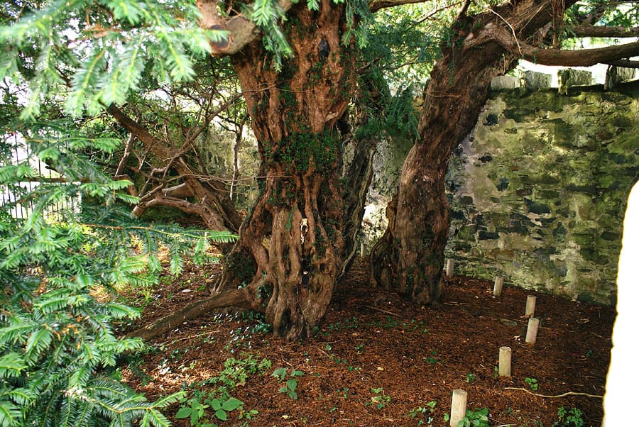
Fortingall Yew Tree and Church, Perthshire, Scotland
Fortingall, Alba / Scotland, United Kingdom
8.2 km away
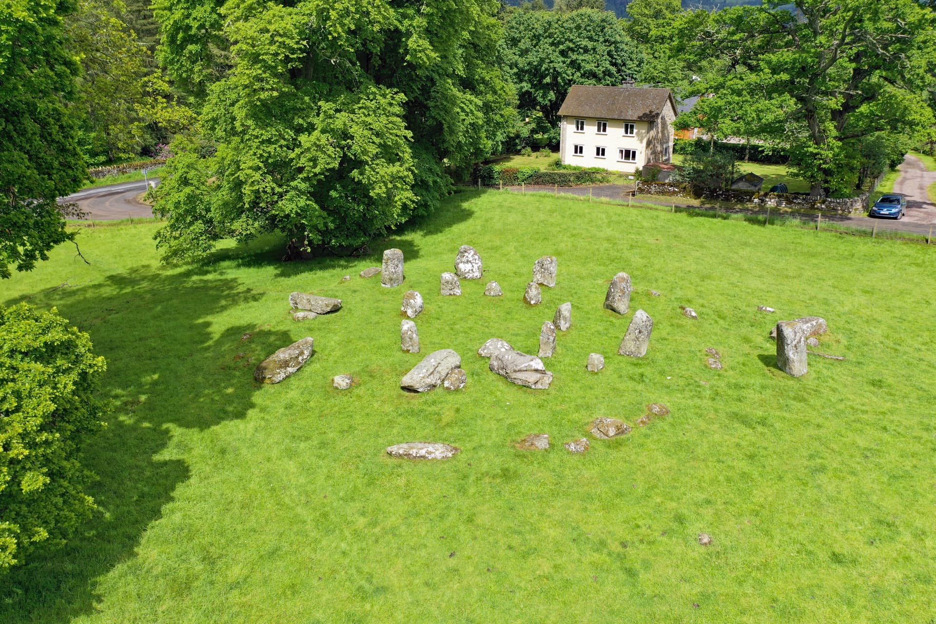
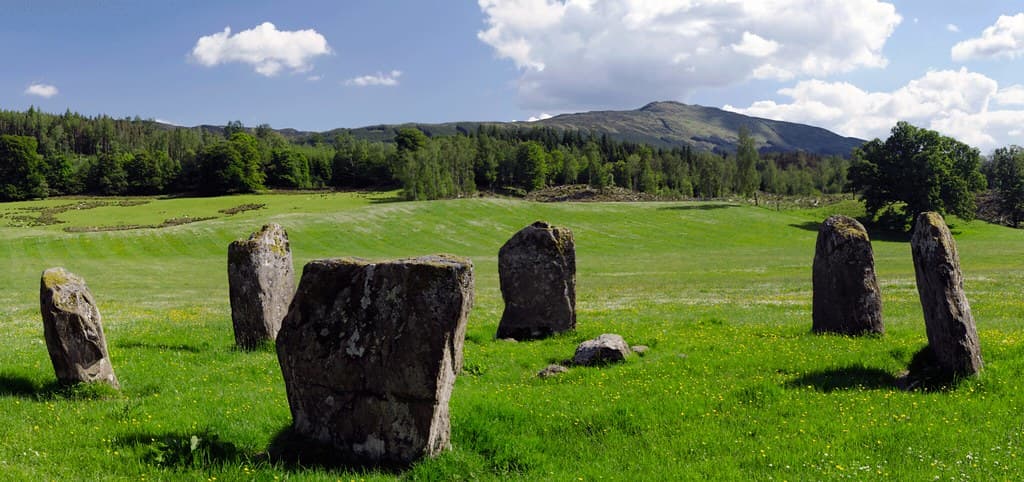
Croft Moraig Stone Circle, Aberfeldy
Aberfeldy, Alba / Scotland, United Kingdom
11.2 km away
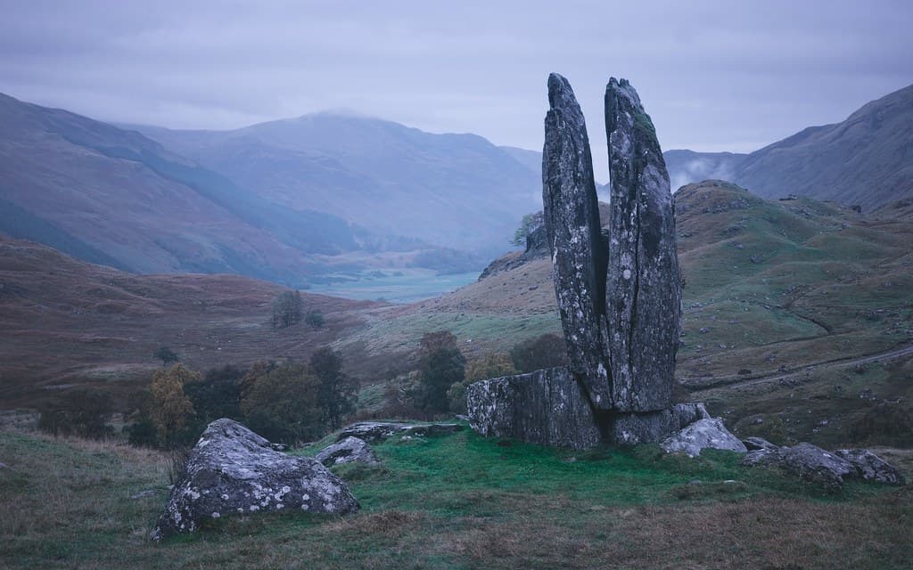
Praying Hands of Mary
Fortingall, Alba / Scotland, United Kingdom
13.2 km away
Kinnell stone circle, Killin
Killin, Alba / Scotland, United Kingdom
25.8 km away
References
Sources consulted when researching this page. Independent verification by readers is welcome.
- 01East Schiehallion — John Muir Trusthigh-reliability
- 02Folklore and the Fairy Hill — John Muir Trusthigh-reliability
- 03Schiehallion fairies — John Muir Trusthigh-reliability
- 04Schiehallion — Scottish Geology Trusthigh-reliability
- 05Schiehallion — The Geological Society of Londonhigh-reliability
- 06Schiehallion — WalkHighlandshigh-reliability
- 07Gaelic Place Names: 'Sith' and 'Sithean' — The Bottle Imphigh-reliability
- 08Braes of Foss — Forestry and Land Scotlandhigh-reliability
- 09Chasing the line: Hutton's contribution to the invention of contours — Journal of Maps / Queen's University Belfasthigh-reliability
- 10A song of Schiehallion — Royal Societyhigh-reliability
Key questions
What pilgrims usually ask
- Why is Mount Schiehallion, Scotland considered sacred?
- Explore Schiehallion, the Fairy Hill of the Caledonians. Celtic Otherworld traditions, Beltane observances, and Scotland's most sacred mountain awaits seekers.
- What should I wear at Mount Schiehallion, Scotland?
- No spiritual requirements. Appropriate hillwalking gear is essential: sturdy waterproof boots, warm and waterproof layers, hat and gloves. Scottish mountain weather shifts without warning. Even in summer, conditions can deteriorate rapidly.
- Can I take photos at Mount Schiehallion, Scotland?
- Photography is welcomed. Be mindful of others seeking solitude, particularly on the summit. If you encounter individuals engaged in contemplative practice, give them space.
- How long should I spend at Mount Schiehallion, Scotland?
- 5-6 hours allowing time for summit contemplation
- What offerings are appropriate at Mount Schiehallion, Scotland?
- Traditional offerings at the fairy well included garlands and coins. If you feel moved to leave something, use only biodegradable natural materials that will not harm wildlife or the environment. Better yet, make your offering internal—attention, gratitude, acknowledgment require no physical expression.
- What etiquette should visitors follow at Mount Schiehallion, Scotland?
- Schiehallion requires practical respect for the mountain environment and cultural respect for its traditions. Stay on designated paths to protect fragile habitat. Do not leave offerings that could harm wildlife or the landscape. Approach with awareness that this is ground humans have considered sacred for millennia.
- What is the history of Mount Schiehallion, Scotland?
- No founding narrative exists for Schiehallion's sacredness—the mountain predates such stories. What survives is a name: Sidh Chailleann, Fairy Hill of the Caledonians. The Caledonians were the Brittonic-speaking tribal confederacy that gave Scotland its name (Caledonia) and resisted Roman incursion. Their presence is confirmed by nearby Dunkeld—Dun Chailleann, Fort of the Caledonians—which shares Schiehallion's etymological root. The folklore that accumulated around the mountain tells of the aos sidhe dwelling within, of Queen Mab in green silk robes presiding over annual gatherings of fairy tribes, of the Cailleach Bheur riding storms from its summit to deal icy death to winter travellers. These stories cannot be dated precisely, but they speak to continuous recognition of the mountain as a place of power. In 1774, the mountain entered scientific history when Astronomer Royal Nevil Maskelyne conducted an experiment to measure Earth's density by observing how the mountain's mass deflected a plumb line. The site was chosen by Charles Mason—of Mason-Dixon Line fame—for its isolation and regular shape. The experiment succeeded, and mathematician Charles Hutton, analysing the survey data, invented contour lines to represent terrain. Schiehallion thus holds an unexpected place in the history of cartography.
- Who is associated with Mount Schiehallion, Scotland?
- Nevil Maskelyne (historical), Charles Hutton (historical), The Cailleach Bheur (mythological)