Bin Tepe
Over a hundred earthen mounds mark where the kings of Lydia lay — a royal necropolis that outlasted the empire
Manisa, north of Sardis near Marmara Gölü, Turkey
Plan this visit
Practical context before you go
1–2 hours; best combined with a Sardis visit (8 km south) for a full day of Lydian heritage.
Located on the southern shore of Marmara Gölü (Lake), Manisa Province, approximately 8 km north of Sardis / Sart. Accessible by car from the Sardis area via local roads. No formal car park or ticket office confirmed — visitors typically drive along the ridge road. Coordinates: 38.5769°N, 27.9933°E.
Open archaeological landscape with no formal visitor infrastructure; treat the mounds and surrounding land with care.
At a glance
- Coordinates
- 38.5769, 27.9933
- Type
- Royal Tumulus Cemetery
- Suggested duration
- 1–2 hours; best combined with a Sardis visit (8 km south) for a full day of Lydian heritage.
- Access
- Located on the southern shore of Marmara Gölü (Lake), Manisa Province, approximately 8 km north of Sardis / Sart. Accessible by car from the Sardis area via local roads. No formal car park or ticket office confirmed — visitors typically drive along the ridge road. Coordinates: 38.5769°N, 27.9933°E.
Pilgrim tips
- No requirements; sturdy footwear for uneven terrain. Sun protection is essential in the open ridge environment.
- Freely permitted; the landscape offers panoramic views across the tumuli to Marmara Lake and the Tmolus mountains.
- Do not attempt to climb the large mounds — the slopes are steep and unstable in places, and the mounds are archaeological monuments. Respect surrounding agricultural land; some areas around the mounds are privately owned. No excavation or disturbing of surface material.
Overview
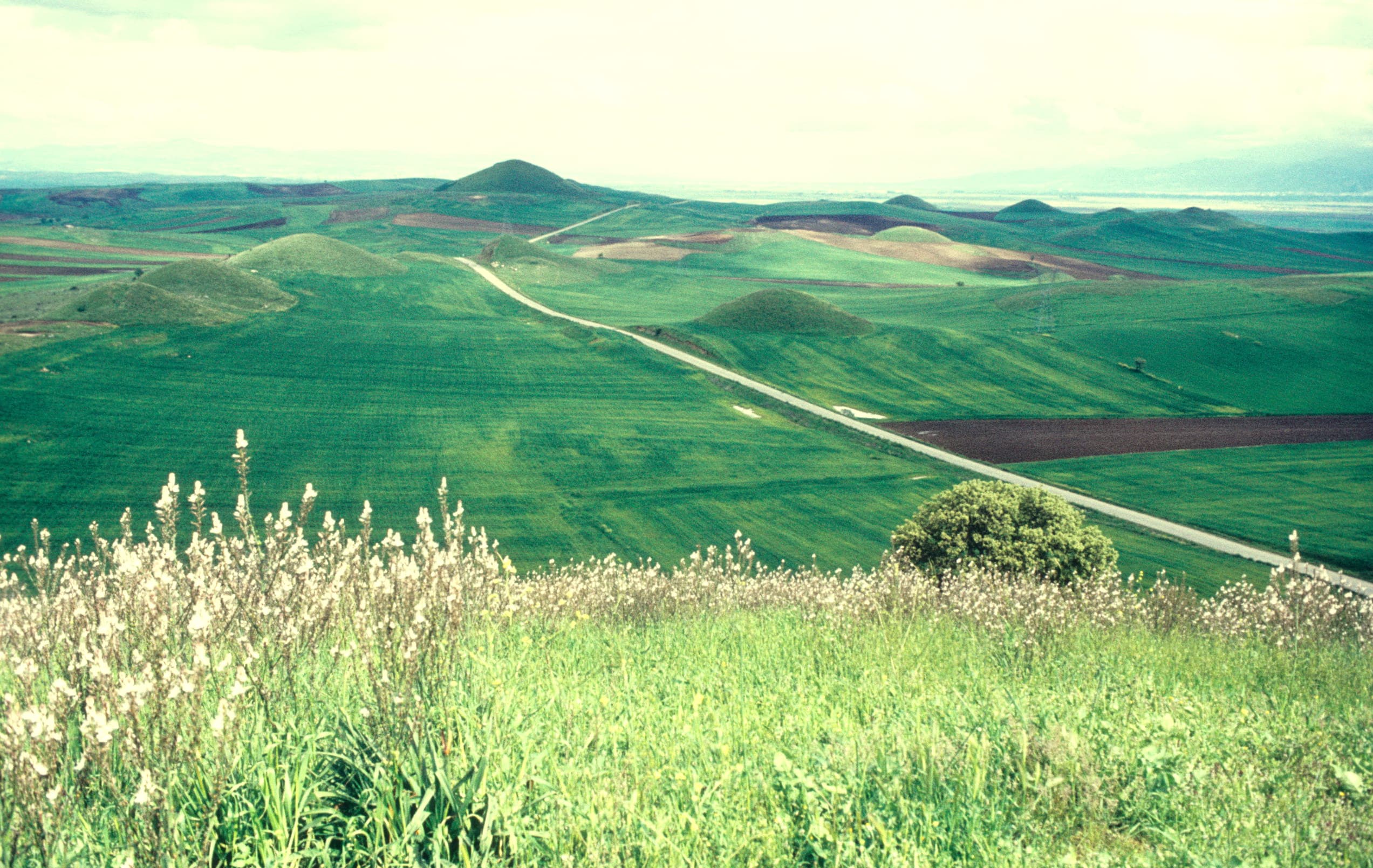
Bin Tepe is the royal tumulus cemetery of the Lydian Mermnad dynasty, located on a ridge above Marmara Lake 8 km north of Sardis. Over 100 earthen burial mounds, including the Alyattes tumulus (355 m diameter, 69 m high — one of the largest in the world), were built between approximately 680 and 540 BC. Jointly inscribed with Sardis as a UNESCO World Heritage Site in 2025.
The ridge above Marmara Lake in western Anatolia holds more than a hundred earthen mounds that rise and fall against the sky — the buried dead of a civilisation that invented coinage, rivalled Egypt, and then vanished so completely that its language is now known only from inscriptions and its kings from a handful of chapters in Herodotus. Bin Tepe means 'thousand hills' in Turkish, though the actual count is somewhat over a hundred; the name expresses something true about the cumulative impression of the landscape.
The three largest tumuli belong, or are attributed, to the Mermnad dynasty — the royal line that ruled Lydia from Gyges (c.680 BC) to Croesus, the last Lydian king, defeated by Cyrus of Persia in 546 BC. The largest of the three, the Alyattes tumulus, has a base diameter of 355 metres and rises 69 metres above the surrounding plain. Herodotus, who visited in the 5th century BC, called it the second greatest monument in the world after the pyramids and the walls of Babylon. He was exaggerating, but not absurdly.
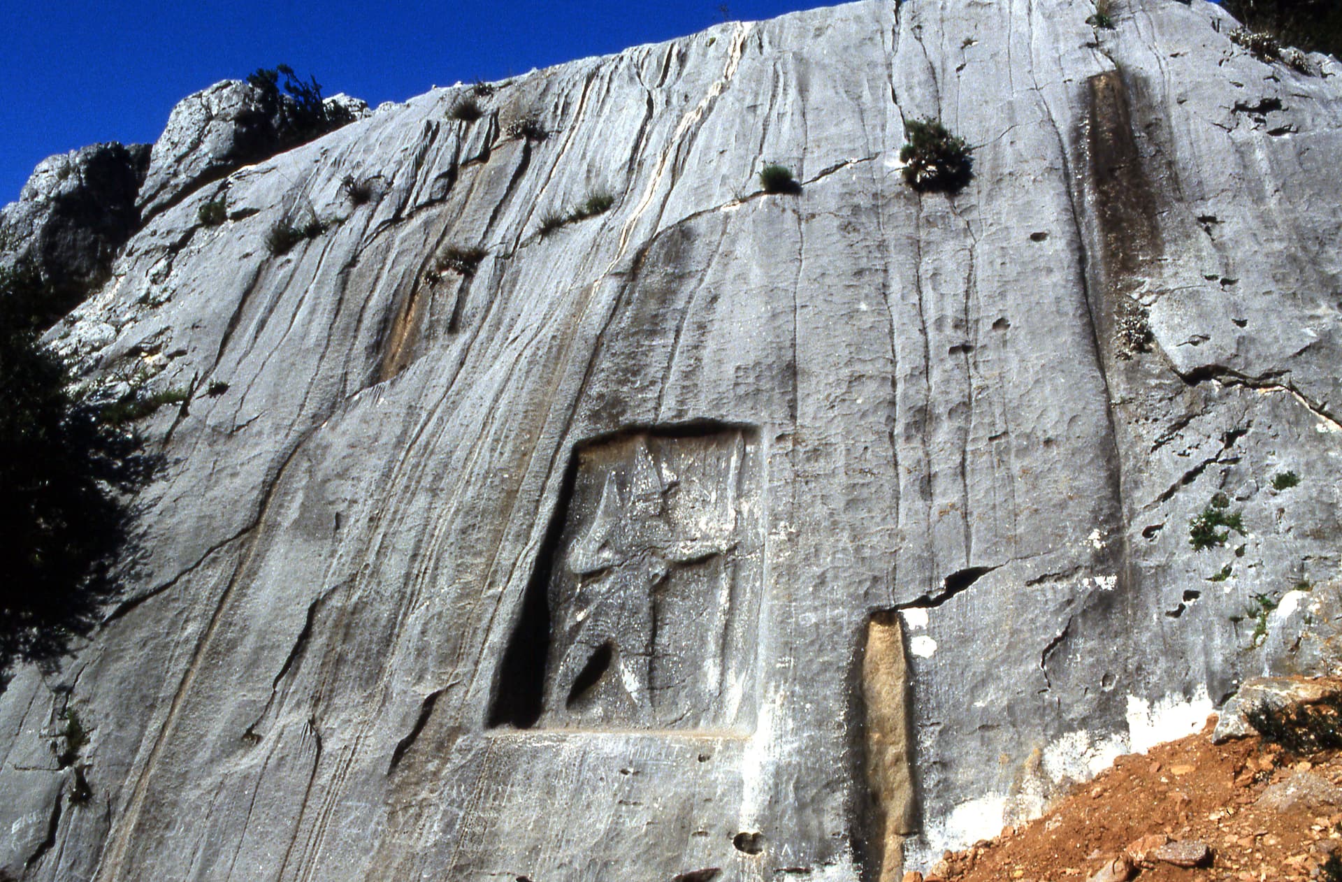
Each major mound enclosed a stone burial chamber, built off-centre within the mound to frustrate grave robbers (it did not work; most chambers were found looted in antiquity). In 1853 a Prussian archaeologist named Spiegelthal tunnelled 235 metres into the Alyattes mound and reached the central chamber — the first documented entry since antiquity. The chamber was empty. What the Lydian kings took with them into the earth, or what was taken from them, is not known.
What remains is the landscape: the mounds silhouetted against the Tmolus mountains, the lake below, the silence of an open-air necropolis whose occupants once commanded the richest empire in the Aegean world.
Context and lineage
The Lydian Mermnad dynasty, founded by Gyges around 680 BC, established their royal necropolis on the ridge above what is now Marmara Lake, within sight of their capital at Sardis. The tradition of burial under large earthen tumuli was adapted from Phrygian practice at Gordion — the Lydians knew and competed with the monumental burial customs of their Anatolian neighbours. Herodotus describes the Alyattes tumulus in his Histories (I.93) and notes the unusual communal character of its construction: the monument was attributed partly to the city's prostitutes, who contributed their own labour pillar. He also notes that five stone pillars stood on its summit marking each contributing group — none survive.
Bin Tepe belongs to a tradition of monumental tumulus burial that spans from Phrygian Gordion westward to Etruscan Italy and northward to Scythian kurgans of the Eurasian steppe — an ancient pan-Eurasian practice of marking elite death with a mound visible across a landscape. The Lydian tumuli are among the most ambitious expression of this tradition in the eastern Mediterranean. The site's 2025 UNESCO inscription as part of the combined Sardis-Bin Tepe nomination recognises both the mounds themselves and their relationship to the living city they served.
Why this place is sacred
The thinness of Bin Tepe is not the thinness of a sanctuary or a temple — it is the thinness of a necropolis, which is to say it concerns the threshold between the living and the dead, between a named individual and the earth that consumed them. The Lydian kings who lie under these mounds were once the most powerful men in the Aegean world. Croesus was wealthier than any Greek had imagined a human being could be. His wealth became a moral archetype. His defeat became a cautionary tale about divine judgment and human hubris. And then Lydia ceased to exist as a political entity, its language gradually died, and the mounds remained.
Herodotus describes the construction of the Alyattes tumulus in an unusual detail: the work was divided among merchants, craftsmen, and prostitutes, each group erecting a separate memorial pillar on the summit. This communal labour in service of a royal burial — every stratum of society contributing to the monument — suggests that the tumulus was experienced not as the king's possession alone but as a collective act of remembrance. The Lydians understood, apparently, that the meaning of a king's death was not his alone.
For the modern visitor, Bin Tepe works as a meditation on scale, time, and the reversibility of greatness. The mounds are enormous. The empire they commemorate is gone. The contrast between the tremendous effort invested in these monuments and the near-total erasure of the culture that built them is philosophically available in a way that few places in the world make so immediate.
Royal necropolis of the Lydian Mermnad dynasty; burial mounds for kings and aristocratic elite from c.680 to 540 BC, with possible continuation into the Achaemenid (Persian) period.
The tumuli were constructed during the Mermnad dynasty's reign (c.680–546 BC) and likely into the early Achaemenid period after Persian conquest. Most chambers were looted in antiquity, possibly during or soon after the Persian conquest. The site was described by Herodotus in the 5th century BC but subsequently fell from active memory. Spiegelthal's 1853 tunnelling expedition was the first documented re-entry since antiquity. The Harvard-Cornell expedition has conducted ongoing survey and selective investigation since the 1960s. UNESCO World Heritage inscription was achieved in 2025 as part of the combined Sardis and Bin Tepe nomination.
Traditions and practice
Lydian royal burial rites at Bin Tepe included the construction of the mound itself as a communal act, placement of the royal dead in stone-lined chambers with grave goods (pottery, bronze, jewellery), and possible funerary games. Herodotus's description suggests that the construction ceremony was itself a form of ritual performance — the division of labour among social groups, the erection of memorial pillars, the collective participation of the city in marking the king's death. Whether ongoing veneration of the royal ancestors at the mounds took place after burial is not documented but consistent with broader ancient Near Eastern funerary practice.
No active religious or ceremonial practices are conducted at Bin Tepe.
Walk the base of the Alyattes tumulus if the terrain allows — the full circuit takes 20–30 minutes and gives the most direct experience of its scale. The labour argument becomes physically legible: the mound required enormous and sustained collective effort, and walking around it is a way of honouring that effort. Pause at the mound's highest point that is accessible from outside and look across the lake and valley. If you have visited Sardis first, this landscape view connects the royal necropolis to the living city it served — the kings buried here would have been carried from the city below. At the smaller mounds, move slowly and allow yourself to notice the variety: different sizes, different states of preservation, different positions relative to the ridge. Each represents an individual who expected to be remembered.
Lydian Royal Funerary Tradition
HistoricalThe Bin Tepe tumuli represent the apex of Lydian royal burial practice, adapted from Phrygian tumulus customs. The three largest mounds are among the largest tumulus tombs in the world. Herodotus described the Alyattes tumulus as second only to the tombs of Egypt and Babylon.
Burial in stone-lined chambers with grave goods; communal mound construction involving all social strata; possible funerary games and feasting; memorial pillars on the summit of the Alyattes mound (documented by Herodotus, now lost).
Experience and perspectives
Bin Tepe is not yet a site with a visitor centre, guided tours, or interpretive boards at each mound. It is an open landscape — a ridge road runs approximately along the cemetery's length, and the mounds rise on both sides, some close to the road, others set back across agricultural fields. This informality is, for now, the site's most striking quality.
The three large mounds are immediately recognisable by scale. The Alyattes tumulus rises on the western part of the ridge — a hill that is obviously not natural, too regular in its profile, too steep on its flanks to be the product of water and time. Standing at its base, you can walk its circumference (over a kilometre) and gauge the labour that went into it. The stone blocks at the base, laid in tight courses before the earth was piled above them, are still visible in places. There is no entrance, no chamber to enter: the king's interior is sealed. Spiegelthal's 1853 tunnel has been closed.
The smaller mounds — dozens of them, many clearly visible from the ridge road, others barely distinguishable from natural rises in the agricultural land — create the peculiar sensation of walking through a field of graves without knowing which ground between them might also be sacred. The Lydians buried their aristocracy here alongside their kings, and the smaller tumuli belong to a social hierarchy that is now illegible.
Dawn and late afternoon are the moments the site rewards most. The low light catches the contours of the mounds against the flat surface of Marmara Lake below, and the Tmolus mountains provide a backdrop that suggests the landscape has not changed much since the Lydian period. Bring water, good walking shoes, and no expectations of guided interpretation.
Drive or take a local road north from Sardis (approximately 8 km) toward the Marmara Lake shore. The ridge road passes along the main cemetery area. Stop at the Alyattes tumulus first — its scale is the orientation point for everything else. Then walk or drive along the ridge to observe the range and variety of the smaller mounds. No formal entrance or ticket required at present.
Bin Tepe is interpreted primarily through Lydian royal funerary studies and monumental landscape archaeology, with Herodotus providing the only ancient narrative account.
Bin Tepe is the royal tumulus cemetery of the Lydian Mermnad dynasty (c.680–540 BC). The three largest mounds are associated with Mermnad kings; only the Alyattes tumulus is securely attributed. The cemetery drew on Phrygian tumulus traditions at Gordion and represents one of the most ambitious funerary landscape projects of the ancient Near East. Ground-penetrating radar mapping and selective excavation by the Harvard-Cornell expedition continue to reveal the full extent and internal structure of the mounds. The 2025 UNESCO inscription recognises the site's outstanding universal value in the context of Lydian civilisation.
No living Lydian tradition. Herodotus's account in the Histories (I.93) is the primary ancient narrative source — his description of the communal construction of the Alyattes tumulus and the stone pillars on its summit is the closest thing to a traditional account. No continuous memorial or veneration practice is documented after the Achaemenid period.
Some writers have compared Bin Tepe to other royal tumulus traditions — Phrygian Gordion, Scythian kurgans, Etruscan tumuli at Cerveteri — as evidence of a pan-Eurasian sacred burial landscape. The comparison is archaeologically productive without requiring esoteric interpretation.
Most burial chambers were found looted in antiquity; what grave goods were removed and where they went is not known. The identities of the occupants of all but the Alyattes tumulus are uncertain — the attribution of specific mounds to Gyges and Croesus is probable but not confirmed. The full number of mounds may exceed current documentation if smaller ones have been obscured under agricultural soil. Whether any ongoing ancestor veneration at the mounds took place after the Persian conquest is undocumented.
Visit planning
Located on the southern shore of Marmara Gölü (Lake), Manisa Province, approximately 8 km north of Sardis / Sart. Accessible by car from the Sardis area via local roads. No formal car park or ticket office confirmed — visitors typically drive along the ridge road. Coordinates: 38.5769°N, 27.9933°E.
Accommodation in Salihli (near Sardis) or İzmir (80 km west) serves both Sardis and Bin Tepe. No accommodation confirmed at or near Bin Tepe itself.
Open archaeological landscape with no formal visitor infrastructure; treat the mounds and surrounding land with care.
No requirements; sturdy footwear for uneven terrain. Sun protection is essential in the open ridge environment.
Freely permitted; the landscape offers panoramic views across the tumuli to Marmara Lake and the Tmolus mountains.
Not applicable.
Do not climb or excavate the mounds. Do not remove any material from the site. Respect the boundaries of surrounding agricultural land.
Nearby sacred places
Sacred places within a half-day’s reach. Pilgrims often visit them together: walk one, stay for the other.


References
Sources consulted when researching this page. Independent verification by readers is welcome.
- 01Bin Tepe, The Tumulus of Alyattes, and Karnıyarık Tepe — Archaeological Exploration of Sardishigh-reliability
- 02Lydian Burial Customs — Elizabeth Baughan / Archaeological Exploration of Sardishigh-reliability
- 03Sardis and the Lydian Tumuli of Bin Tepe – UNESCO World Heritage Centre — UNESCOhigh-reliability
- 04Ancient City of Sardis and Lydian Tumuli of Bin Tepe join UNESCO world heritage list — Anadolu Agencyhigh-reliability
- 05Bin Tepe – Pleiades (ancient world gazetteer) — Pleiades Projecthigh-reliability
- 06Bin Tepe – Wikipedia — Wikipedia contributors
- 07Bin Tepe – Livius.org — Jona Lendering / Livius.org
- 08Bigger than Giza? Ancient Lydian royal tombs rise over western Türkiye — Türkiye Today
- 09This Site In Turkey Is Home To Over 100 Burial Mounds (& The Largest Is Over 100 Feet Tall) — The Travel
- 10Discover Türkiye's 22nd Unesco World Heritage Site: Sardis and Lydian Tumuli of Bintepe — Tatler Asia
Key questions
What pilgrims usually ask
- Why is Bin Tepe considered sacred?
- Bin Tepe holds over 100 Lydian royal burial mounds near Sardis, including the vast Alyattes tumulus — a UNESCO-inscribed necropolis above Marmara Lake in wester
- What should I wear at Bin Tepe?
- No requirements; sturdy footwear for uneven terrain. Sun protection is essential in the open ridge environment.
- Can I take photos at Bin Tepe?
- Freely permitted; the landscape offers panoramic views across the tumuli to Marmara Lake and the Tmolus mountains.
- How long should I spend at Bin Tepe?
- 1–2 hours; best combined with a Sardis visit (8 km south) for a full day of Lydian heritage.
- How do you visit Bin Tepe?
- Located on the southern shore of Marmara Gölü (Lake), Manisa Province, approximately 8 km north of Sardis / Sart. Accessible by car from the Sardis area via local roads. No formal car park or ticket office confirmed — visitors typically drive along the ridge road. Coordinates: 38.5769°N, 27.9933°E.
- What offerings are appropriate at Bin Tepe?
- Not applicable.
- What etiquette should visitors follow at Bin Tepe?
- Open archaeological landscape with no formal visitor infrastructure; treat the mounds and surrounding land with care.
- What is the history of Bin Tepe?
- The Lydian Mermnad dynasty, founded by Gyges around 680 BC, established their royal necropolis on the ridge above what is now Marmara Lake, within sight of their capital at Sardis. The tradition of burial under large earthen tumuli was adapted from Phrygian practice at Gordion — the Lydians knew and competed with the monumental burial customs of their Anatolian neighbours. Herodotus describes the Alyattes tumulus in his Histories (I.93) and notes the unusual communal character of its construction: the monument was attributed partly to the city's prostitutes, who contributed their own labour pillar. He also notes that five stone pillars stood on its summit marking each contributing group — none survive.