N'Dhala Gorge Nature Park
A red sandstone gorge holding one of Central Australia's densest petroglyph fields
Understand sacred places, explore living traditions, and learn how to engage respectfully with Pilgrim Map.
Access has not been verified. Check current local guidance before planning a visit.
Ross River / Alice Springs region, Northern Territory, Northern Territory, Australia
Read the sources
Visit essentials
A quick read before you go
- Duration
- The main marked walking track is approximately 1.5 kilometers and takes about one hour return.
- Access
- N'Dhala Gorge lies roughly 90 kilometers east of Alice Springs via the Ross Highway.
Overview
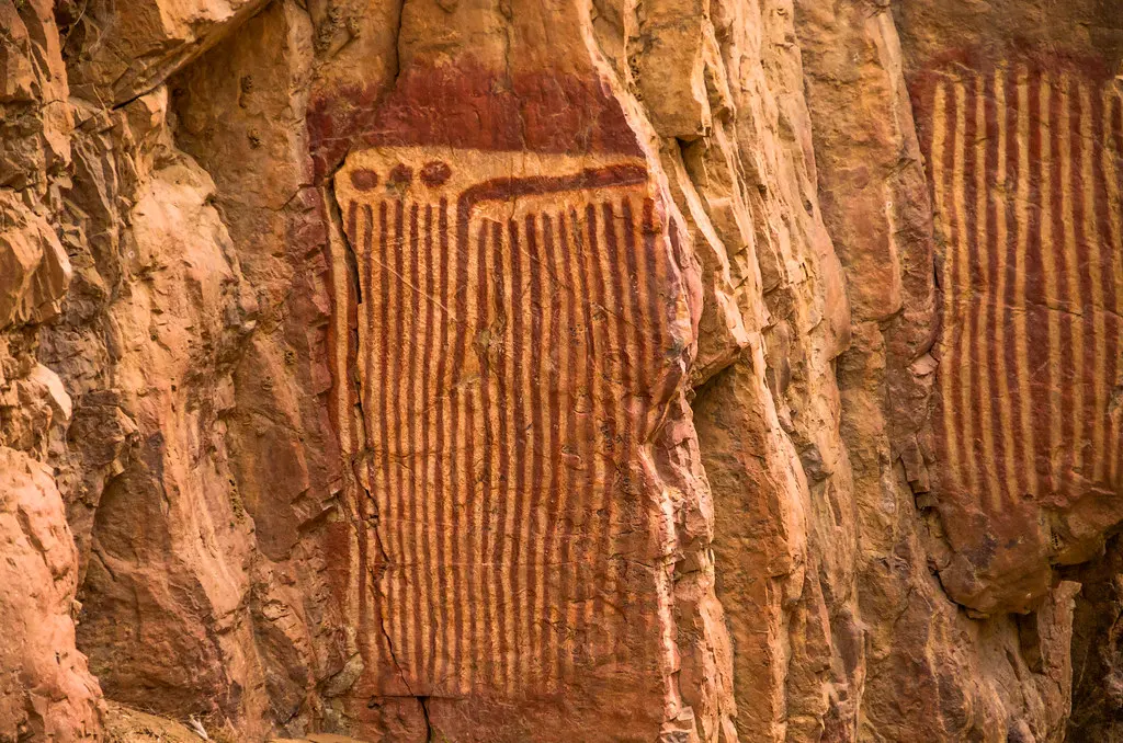
N'Dhala Gorge, known to Eastern Arrernte custodians as Irlwentje (also Ilwentje or Ilweltje), is a narrow sandstone chasm in the East MacDonnell Ranges, reached only by a 4WD track past Ross River Homestead. Along its walls and a smaller side gorge, close to 6,000 rock engravings mark stone shaped by intermittent floodwater. Archaeologists identify two broad phases of engraving activity, roughly 10,000 and 3,000 years old, made by percussion and fine pecking into weathered faces.
For Eastern Arrernte people, this is not primarily an archaeological site but Country. It carries Dreaming narratives associated with the region's Caterpillar Dreaming tradition and contains men's sacred sites whose content is not for general publication.
Title returned to Traditional Owners through the Irlwentye Aboriginal Land Trust in 2009. The park is leased back to the Northern Territory Government for 99 years under joint management, keeping custodianship active rather than symbolic. A one-hour walking track enters only the publicly shared part of the gorge: its visible engravings, plant life, and quiet.
Why this place is sacred
What gives N'Dhala Gorge its particular weight is scale meeting intimacy. Within a corridor barely wide enough for two people to walk shoulder to shoulder, sandstone walls carry engravings numbering in the thousands — current counts put roughly 438 engraved sites in the main gorge and 240 more in a side gorge, adding up to close to 6,000 individual marks.
Some were pecked into the rock some ten thousand years ago; others were added roughly three thousand years ago, a second wave of attention to the same walls by descendants of the first. Few places allow a visitor to stand in front of markings that old while walking a track that takes about an hour.
The remoteness compounds the effect: reaching the gorge means driving 90 kilometers east of Alice Springs, the last stretch navigable only by four-wheel drive, so the gorge is rarely crowded and rarely loud. Visitors and tourism accounts consistently describe this combination — antiquity, density, isolation — as producing an unusually direct sense of ancestral presence, distinct from sites where similar rock art is viewed from behind glass or interpretive fencing.
Here the engravings are simply on the walls, in the open air, where they were made.
The sandstone overhangs and shelters within the gorge served Eastern Arrernte people historically as both physical shelter and ceremonial setting, consistent with the gorge's status as a place containing men's sacred sites. The specific content and form of ceremonies conducted there is restricted knowledge and is not detailed in available public sources — a boundary this content observes rather than attempts to work around.
The gorge functioned as living Arrernte Country and ceremonial ground long before it entered the Northern Territory's protected-area system, gazetted in 1962. For nearly five decades it existed as government-declared parkland without formal Traditional Owner title.
That changed in 2009, when title was returned to Traditional Owners through the Irlwentye Aboriginal Land Trust, who then leased the land back to the Northern Territory Government for 99 years under a joint management arrangement — a structural shift from state-held heritage site to jointly stewarded Country, with Traditional Owners as formal partners in how the place is managed and interpreted for visitors today.
Experience and orientation
The approach itself sets the tone: after Ross River Homestead, the road narrows and roughens, requiring four-wheel drive for the final stretch, and the gorge announces itself as a place that asks something of the traveler before it is reached. The walking track follows the gorge floor, an intermittently dry watercourse bounded by red sandstone that rises steeply on either side, throwing the path into shade for long stretches even in the middle of the day.
Engravings appear early and continue throughout — not clustered in one obvious showcase wall but scattered across the full 1.5-kilometer length, on overhangs, at eye level, and higher on faces that would have required deliberate effort to reach. Interpretive signage along the way situates the archaeological dating and general cultural context without attempting to explain the meaning of specific images, an appropriate restraint given the site's mixed public and restricted content.
Rare plants — Hayes wattle and peach-leafed poison bush among them — appear in pockets where the gorge's microclimate departs from the surrounding arid scrubland. The return walk takes about an hour; visitors who continue into the smaller side gorge, home to a further 240 engraved sites, should expect to add meaningfully more time. Bush camping is available nearby, without water, for those who want to sit with the place past a single afternoon visit.
Arrive with a full tank and a suitable vehicle — 2WD cannot complete the final approach — and plan the visit for the cooler months between April and September, when Central Australian daytime heat is more forgiving of an unshaded walk. Bring water regardless of season.
Context and lineage
Tourism materials that draw on Arrernte custodial knowledge describe the gorge's engravings as relating to a creation-era narrative following the life cycle of two caterpillars, named in some sources as Utnerrengatye and Ntjarlke, moving through stages from caterpillar to butterfly within a broader framework in which ancestral beings shaped the land, language, and law of the region.
This narrative is associated with, or related to, the better-known Caterpillar Dreaming (Yeperenye) tradition centered at Emily Gap (Anthewerrke) closer to Alice Springs, though available sources do not clarify whether the N'Dhala story is the same narrative cycle or a distinct, locally specific one.
In keeping with the site's restricted status, this summary reflects only what Traditional Owner-referencing sources have already made public; it does not extend into interpretation of the men's sacred site content that the Northern Territory Government's own 2011 Joint Management Plan formally identifies as present at the gorge and not intended for general circulation.
Custodianship of Irlwentje runs through Eastern Arrernte families connected to the East MacDonnell Ranges, formally recognized in 2009 when land title passed to the Irlwentye Aboriginal Land Trust and the park was leased back to the Northern Territory Government for joint management — a continuation of custodial responsibility rather than its creation.
Sarah Forbes
Archaeologist
Author of a 1982 Australian National University honours thesis analyzing N'Dhala Gorge's rock engravings as an example of Central Australian 'Panaramitee style' rock art, originally proposed as a research project by the Northern Territory Conservation Commission. Her work remains the primary academic source on the site's engraving techniques and stylistic classification.
Traditions and practice
The gorge's sandstone shelters and overhangs were used historically by Eastern Arrernte people for ceremony, consistent with the site's recognized status as containing men's sacred sites. No available source — academic, governmental, or traditional-owner-referencing — publicly details the content, form, or frequency of these ceremonies, and this content deliberately does not speculate about them.
Contemporary custodianship is expressed structurally: through the 2009 return of title to the Irlwentye Aboriginal Land Trust and the subsequent 99-year joint management lease with the Northern Territory Government, Traditional Owners hold a formal, ongoing role in decisions about the park's management and public interpretation. No source describes ceremonial activity currently conducted at the site that is open to public knowledge.
Visitors are not invited to participate in ceremonial practice at N'Dhala Gorge. The appropriate visitor practice is attentive walking of the marked public trail: reading the interpretive signage, observing engravings without touching them, and holding the awareness that parts of the gorge carry meaning that is not the visitor's to access or interpret.
Eastern Arrernte tradition
ActiveN'Dhala Gorge (Irlwentje) is Eastern Arrernte Country containing men's sacred sites, ceremonial shelter sites, and one of Central Australia's densest concentrations of ancestral rock engravings. Title to the land returned to Traditional Owners via the Irlwentye Aboriginal Land Trust in 2009, with the park subsequently leased back to the Northern Territory Government for 99 years under joint management — an ongoing, formally structured custodianship rather than a historical claim.
Contemporary practice is expressed through joint management between Traditional Owners and the NT Parks and Wildlife Commission, and through continued custodianship of restricted men's sacred site knowledge, which is not detailed in public materials including this content.
Archaeological and heritage-conservation tradition
ActiveN'Dhala Gorge is a recognized site of Panaramitee-style rock engraving, studied academically since at least 1982, and is protected as a Northern Territory Nature Park (IUCN Category V) with ongoing joint management between government heritage authorities and Traditional Owners.
Ongoing protection of the site through Northern Territory park management, visitor infrastructure (marked trail, interpretive signage, permit system), and the historical academic study represented by Forbes' 1982 thesis.
Perspectives and open questions
N'Dhala Gorge is read differently depending on the lens brought to it — as an archaeological record of Panaramitee-style engraving, as living Eastern Arrernte Country, or as a site whose full significance is, by its own custodians' design, only partially knowable to outsiders.
Scholarly perspective
Archaeologically, N'Dhala Gorge is recognized as a significant Central Australian example of Panaramitee-style rock engraving, per Sarah Forbes' 1982 ANU honours thesis. Engraving activity is estimated across two broad phases, roughly 10,000 and 3,000 years ago, using both percussion and fine pecking techniques. Researchers treat the site as part of a wider pattern of ancient, stylistically related petroglyph traditions distributed across arid Central Australia, rather than as an isolated phenomenon.
Living and traditional perspectives
Eastern Arrernte Traditional Owners hold N'Dhala Gorge (Irlwentje) as active Country containing men's sacred sites and Dreaming narratives. Tourism materials referencing Arrernte custodians describe the engravings as relating to a caterpillar life-cycle story, connected to the broader Caterpillar Dreaming tradition. Formal recognition of ongoing custodianship is reflected in the 2009 transfer of title to the Irlwentye Aboriginal Land Trust and the subsequent joint management arrangement with the Northern Territory Government.
Certain associated knowledge remains restricted to appropriate audiences and is not detailed in this or any public source consulted.
Alternative interpretations
No alternative or esoteric interpretive framework — New Age, ley-line, or otherwise — was identified for this site in available research. It does not appear to hold a place within that literature.
Open questions
Open questions include the precise relationship between the locally named caterpillar figures at N'Dhala and the more widely publicized Yeperenye Caterpillar Dreaming centered at Emily Gap; the specific content and scope of the restricted men's sacred site material, which is deliberately not investigated here; and more precise dating and attribution of the two broad engraving phases beyond the general estimates of roughly 10,000 and 3,000 years.
Plan your visit
Access and arrival
N'Dhala Gorge lies roughly 90 kilometers east of Alice Springs via the Ross Highway. The track becomes four-wheel-drive only beyond Ross River Homestead/Resort; standard two-wheel-drive vehicles cannot complete the approach. An NT Parks visitor pass is required. Bush camping is available on-site with toilets and picnic tables but no water supply — bring your own. Camping requires advance fees and online booking.
Mobile phone signal should not be assumed reliable this far from Alice Springs; travelers should plan for limited connectivity and treat Ross River Homestead as the nearest point of more reliable contact before the final unpaved stretch. No source-confirmed keyholder or booking contact beyond standard NT Parks and Wildlife Commission booking channels was identified; check the official NT Parks website for current permit and booking arrangements.
Bush camping is available at N'Dhala Gorge itself (no water on-site). Ross River Homestead/Resort, at the point where the road becomes 4WD-only, is the nearest lodging option along the approach route.
Respectful visit
No specific dress code is documented beyond standard remote-walking practicalities: sun protection, a hat, and sturdy footwear suited to a rocky four-wheel-drive approach and an unshaded walking trail.
No source imposes an outright photography ban on the public walking trail. Given the presence of restricted men's sacred site content elsewhere in the gorge, as flagged in the official Joint Management Plan, visitors should photograph only within the designated trail and interpretive area, avoid close-up images presented as explanations of specific engravings' meaning, and refrain from publishing material that implies access to or understanding of restricted content.
No tradition of visitor offerings is documented at this site.
Stay strictly on designated roads, tracks, and the marked walking path. Do not touch or climb on rock engravings. The 2011 Joint Management Plan formally warns that the document contains cultural information about Indigenous men's sacred sites — a restriction this content honors by not describing, reconstructing, or speculating about that material in any form.
Do not attempt to interpret or explain specific engravings beyond what official interpretive signage provides, and do not photograph or publish material suggesting insight into restricted content — the Joint Management Plan is explicit that some of the gorge's cultural information concerns Indigenous men's sacred sites not intended for general circulation.
Location
Map loads as you approach this section.
Pilgrim reflections
A portrait of encounter, not a score
Pilgrims describe what they felt, how present they could become, and whether the place would shape a journey. There are no stars and no ranking of traditions.
No reviewed reflections yet
The first pilgrims can help describe the character of being here.
Share a reflection
Available after an account-backed “Been there.” Every reflection is reviewed before publication.
Nearby sacred places
Explore other sacred places in the region. Proximity does not establish access or travel time; check each place’s guidance.
Yeperenye / Emily and Jessie Gaps Nature Park
Alice Springs, Northern Territory, Northern Territory, Australia
14.1 km away

Napwerte / Ewaninga Rock Carvings Conservation Reserve
Hale / Alice Springs region, Northern Territory, Northern Territory, Australia
31.7 km away

Simpsons Gap
Alice Springs / Tjoritja, Northern Territory, Northern Territory, Australia
39.1 km away

Chambers Pillar Historical Reserve
Hugh / Alice Springs region, Northern Territory, Northern Territory, Australia
137.3 km away
References
Sources consulted for this page. Source categories describe the publication, not a guarantee that every claim is verified. Traditional accounts and outside interpretations may differ.
- 01N'Dhala Gorge Nature Park Joint Management Plan, October 2011 — Northern Territory Parks and Wildlife Commission / Traditional OwnersofficialOfficial joint management plan co-developed with Traditional Owners; contains a formal cultural-sensitivity warning that the document includes information about Indigenous men's sacred sites. Could not be machine-extracted directly (binary/compressed PDF); referenced via secondary sources and search summaries that cite it.
- 02N'Dhala Gorge Nature Park | NT.GOV.AU — Northern Territory GovernmentofficialOfficial government park page; visitor access, permit, and camping information.
- 03Aboriginal rock engravings at N'Dhala Gorge: an analysis of a Central Australian 'Panaramitee style' rock art site (Honours Thesis) — Sarah Forbesacademic1982 ANU honours thesis, originally proposed as a research project by the NT Conservation Commission via the North Australia Research Unit field grant program. Primary academic archaeological source on the site's Panaramitee-style engravings.
- 04Land won back — Central Land Council — Central Land CouncilofficialDoes not mention N'Dhala Gorge or Irlwentye directly; documents a separate 19 August 1994 Eastern Arrernte land handback (approx. 23,000 sq km in the northern Simpson Desert). Retained here as context on CLC's role and Eastern Arrernte land-rights history, not as a direct N'Dhala source.
- 05N'Dhala Gorge Nature Park — Wikipedia — Wikipedia contributorsacademicCites CAPAD 2016 database, NT Place Names Register, and the Joint Management Plan. Confirms establishment date, Arrernte name (Ilweltje/Ilwentje), and archaeological dating estimates.
- 06Tourism Central Australia — N'Dhala Gorge Nature Park — Tourism Central AustraliaSource contextRegional tourism authority page; visitor access, camping, and a summary cultural-significance note attributing petroglyph interpretation to 'Arrernte custodians of Irlwentye.'
- 07N'Dhala Gorge Nature Park | Things to do in East MacDonnell Ranges — Northern Territory Tourism (northernterritory.com)Source contextNT's official tourism marketing site; supplementary visitor and access detail, and confirms 'men's sacred sites' designation and Ilwentje place name.
- 08Hidden Gems of the NT: Discover N'Dhala Gorge Nature Park — Lets Go Caravan and CampingSource contextTravel blog; used only as a supplementary/corroborating source for engraving counts and Caterpillar Dreaming (Yeperenye) framing, not as a sole source for any claim.
- 09N'Dhala Gorge Nature Reserve — visitors information guide — macdonnellranges.comSource contextIndependent regional travel guide; supplementary practicalities (access route, distances) only.
Share a photo
Help visitors recognize N'Dhala Gorge Nature Park. Every submission is reviewed before publication.