Maeshowe Chambered Cairn
A Neolithic chamber where midwinter sunlight still finds the darkness after five thousand years
Stenness, Orkney Islands, United Kingdom

Plan this visit
Practical context before you go
One hour for the guided tour. Allow additional time for the Visitor Centre, and a half to full day to explore the surrounding Heart of Neolithic Orkney landscape.
Follow your guide. Do not touch the walls or runes. Maintain quiet within the chamber. Be prepared to stoop through a low, narrow passage.
At a glance
- Coordinates
- 58.9966, -3.1882
- Type
- Chambered Cairn
- Suggested duration
- One hour for the guided tour. Allow additional time for the Visitor Centre, and a half to full day to explore the surrounding Heart of Neolithic Orkney landscape.
Pilgrim tips
- Outdoor clothing suitable for Orkney weather. Rain is common. The passage requires stooping; avoid bulky backpacks or rigid clothing that restricts bending. Comfortable, flexible clothing is practical.
- Check with the tour guide. Flash photography may be restricted to protect the runic inscriptions and stonework. The chamber is dimly lit; cameras with low-light capability are useful.
- The entrance passage is less than a metre high and eleven metres long. Those with claustrophobia or mobility restrictions should consider this before booking. Do not touch the walls or runic inscriptions. Follow all instructions from the tour guide.
Overview
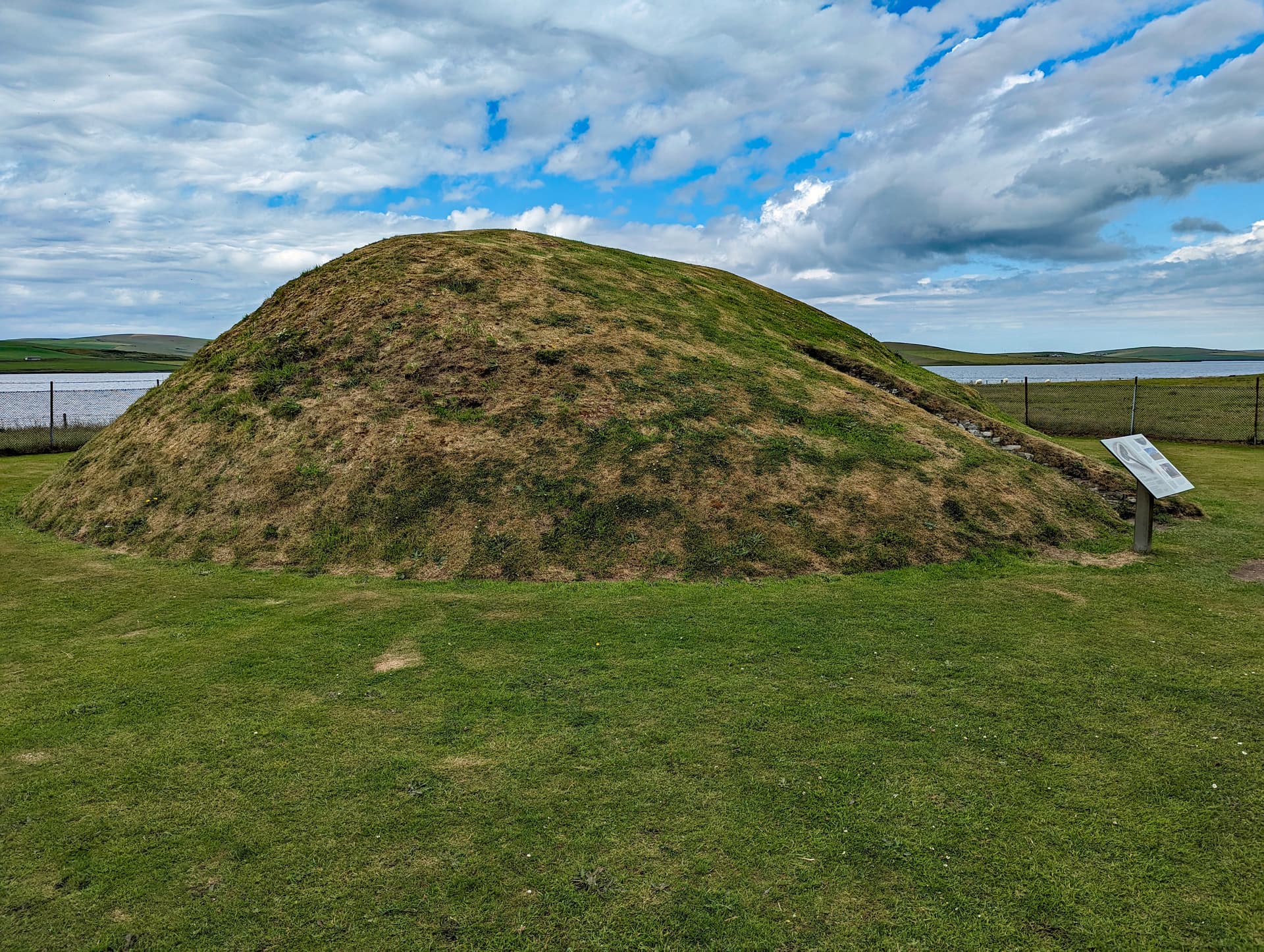
On Mainland Orkney, a grass-covered mound rises seven metres above a surrounding ditch. Beneath it lies a chambered tomb built around 2800 BC with a precision that still astonishes. An eleven-metre passage, barely a metre high, leads to a central chamber of fitted flagstone slabs where three side cells once held the dead. Each midwinter, the setting sun enters the passage and illuminates the chamber's rear wall, a ceremony of light that has repeated for five millennia. Twelve centuries ago, Norse visitors broke in and carved over thirty runic inscriptions on the walls, adding their voices to a conversation that began in the Neolithic and has not yet ended.
Maeshowe sits in the low, wind-swept landscape of Mainland Orkney between the lochs of Harray and Stenness. From a distance it appears as a large grassy mound, unremarkable until you learn what lies within. The mound is thirty-five metres across and seven metres high, encircled by a ditch that was once considerably deeper. It was built around 2800 BC, making it older than the Great Pyramid of Giza and contemporary with the earliest phases of Stonehenge.
The entrance faces southwest. A passage eleven metres long and less than a metre high in its inner section leads into the earth. To enter, you must bend nearly double, your body compressed between walls of carefully fitted flagstone. The passage is a threshold in every sense. It separates the world of daylight from something older and more enclosed.
The central chamber opens around you as you rise to standing. It is roughly four and a half metres square, the walls rising nearly four metres in corbelled courses of dry-stone masonry. In each corner stands a massive buttress stone, angled upward into the vaulting. Three side cells, their openings raised above the floor, wait in the north, east, and western walls. These cells likely held the dead, though remarkably few human remains were found when the tomb was opened in 1861.
The builders worked with Orkney flagstone, cutting and fitting slabs that weigh up to thirty tonnes. They did this without metal tools, without written calculation, without any technology that we would recognise as engineering. What they had was knowledge, patience, and a purpose compelling enough to sustain the labour of a community across years.
At midwinter, the setting sun aligns with the entrance passage. For approximately three weeks around the solstice, light travels down the corridor and strikes the rear wall of the central chamber. Eight hundred metres away, the Barnhouse Stone stands in the alignment, a marker that connects the monument to the wider landscape. This is not accident. The passage was oriented with deliberate precision to capture this annual event, the moment when the year turns and the light begins its return.
The Norse additions came much later. In the twelfth century, groups of Norsemen broke into the chamber and carved over thirty inscriptions in runes on the walls. These form the largest collection of runic inscriptions outside Scandinavia. The carvings range from boastful declarations to expressions of longing. One proclaims its author the most skilled rune-carver in the western ocean. Another immortalises a woman named Ingigerth as the most beautiful of all women. Others speak of treasure. On a corner pillar, a dragon, a walrus, and a knotted serpent were carved into the stone. These inscriptions are not defacement. They are the traces of people who found themselves inside something vast and old and felt compelled to leave their mark.
Context and lineage
Around 2800 BC, Neolithic communities on Mainland Orkney began constructing a monument of extraordinary ambition. They chose a site on the low ground between the lochs of Harray and Stenness, within a landscape already marked by ceremonial activity. They quarried flagstone slabs weighing up to thirty tonnes and fitted them with a precision that required no mortar. They built a passage eleven metres long, aligned to the southwest so that the midwinter sunset would penetrate its full length. They raised a central chamber nearly five metres square with walls rising in corbelled courses. They created three side cells, raised above the floor, to receive what they chose to place within. Then they covered it all with earth and stone, creating a mound thirty-five metres across and seven metres high, encircled by a ditch.
The monument stood in its landscape for nearly four thousand years before it entered written history. The Orkneyinga Saga, composed in the thirteenth century, likely refers to Maeshowe in its account of Norsemen sheltering from a storm and being driven mad by the experience. In the twelfth century, Norse visitors broke into the chamber, possibly seeking treasure, and carved over thirty inscriptions in runes on the walls. They boasted, they declared love, they speculated about hidden gold. They carved a dragon, a walrus, a knotted serpent.
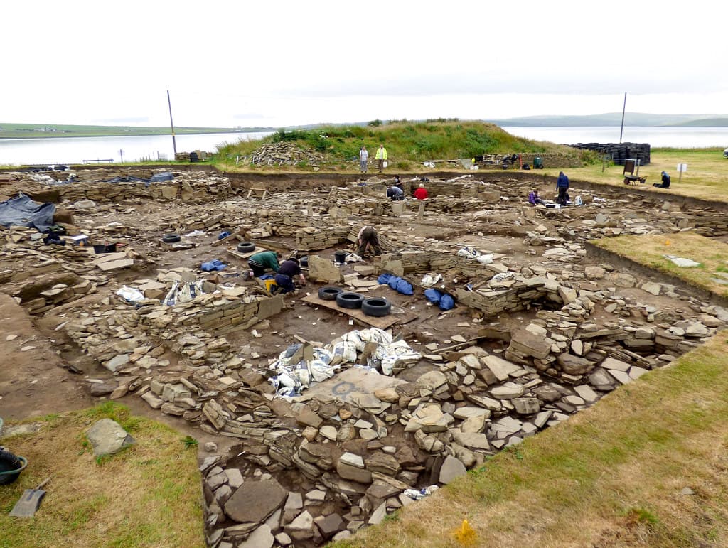
In 1861, antiquarian James Farrer opened the mound, breaking through the roof of the entrance passage. His methods were crude by modern standards. George Petrie, the Orcadian antiquary who followed in his wake, recorded what he saw with greater care. Few artefacts were found: horse bones, a fragment of human skull, and the runic inscriptions that Farrer had uncovered. V. Gordon Childe returned in the 1950s to place the monument in its broader Neolithic context.
No continuous tradition connects the Neolithic builders to the present. The monument's significance is understood through archaeological investigation. Norse use in the twelfth century represents a secondary phase separated by nearly four millennia from the original construction. Today, Historic Environment Scotland manages the site, and the winter solstice event is broadcast via webcam, continuing a relationship between the monument and its audience that has lasted five thousand years.
James Farrer
George Petrie
V. Gordon Childe
Why this place is sacred
The thinness of Maeshowe is built into its structure. The eleven-metre passage that forces you to stoop and crawl before you can stand in the chamber is not merely a practical entrance. It is a designed experience of transition, a physical passage from one state to another. You leave the wind and the light of Orkney behind. You enter darkness, enclosure, silence. You stand where the dead once lay.
The midwinter alignment deepens this quality beyond architecture into cosmology. The Neolithic builders did not simply construct a tomb. They constructed a relationship between the built chamber and the turning of the solar year. For three weeks around the solstice, the setting sun performs what the builders intended. Light enters the darkest place at the darkest time. The symbolism is not subtle, nor does it need to be. Death and renewal, darkness and returning light, the end of the year and its beginning. These are the oldest human concerns, and Maeshowe addresses them not with words but with stone and sunlight.
The blocking stone that sealed the passage had to be operated from inside. This detail, easily overlooked, transforms the monument from a tomb into a stage. Whoever entered the chamber could seal themselves within it, choosing darkness, choosing enclosure with the dead. What happened in that sealed space at midwinter, when the sun's light would have been the only illumination, cannot be recovered. But the architecture makes clear that it was designed to happen.
The Norse runes add another layer of thinness. Twelve centuries after the last Neolithic ceremony, Norsemen stood in the same chamber and felt something strongly enough to carve words into the walls. Their inscriptions speak of beauty, skill, treasure, and ambition. They are profoundly human, and their presence alongside the Neolithic stonework collapses the distance between eras. The chamber held Neolithic ritual, held Norse bravado, and now holds the quiet attention of visitors who stoop through the same passage. The stone remembers all of it.
Built circa 2800 BC as a passage grave and ceremonial chamber. The alignment with the midwinter sunset indicates a cosmological function connected to the solar year. The side cells likely held burials, though the chamber may have served multiple ceremonial purposes beyond the purely funerary.
The monument was opened by antiquarian James Farrer in 1861. Norse groups entered the chamber in the twelfth century and left over thirty runic inscriptions. V. Gordon Childe conducted further excavations in the 1950s. Inscribed as part of the Heart of Neolithic Orkney UNESCO World Heritage Site in 1999. Now managed by Historic Environment Scotland with guided tours operating year-round.
Traditions and practice
The Neolithic builders of Maeshowe practiced funerary rites whose precise form cannot be recovered. The architecture suggests ceremonies conducted within a sealed chamber, possibly timed to the midwinter solstice. The side cells held burials or ritual deposits. The alignment with the Barnhouse Stone indicates the monument was conceived as part of a larger ceremonial landscape. Norse use in the twelfth century involved entering the chamber, carving runes, and possibly seeking treasure.
Guided tours operate year-round. The midwinter solstice illumination is observed in person by small groups and broadcast online by Historic Environment Scotland. Archaeological research continues at the broader Ness of Brodgar site. The monument draws visitors from around the world as part of the Heart of Neolithic Orkney World Heritage Site.
Enter slowly. Let your body register the transition of the passage before your mind tries to interpret the chamber. Stand in silence once inside. Look at the stonework before looking at the runes. Consider the labour that built this place. Consider the purpose that sustained that labour. If you can, visit near the midwinter solstice. If you cannot, know that the alignment is built into the stone whether the sun is shining or not. After the tour, walk to the Stones of Stenness and the Ring of Brodgar. Maeshowe was not built in isolation, and it should not be experienced in isolation.
Neolithic Passage Grave and Ceremonial Tradition
HistoricalMaeshowe was constructed circa 2800 BC as a passage grave oriented to the midwinter sunset. The chamber's design, including the blocking stone that could only be sealed from within, indicates ceremonial practices conducted in darkness and illuminated by the annual return of solstice light. The monument represents one of the most sophisticated expressions of Neolithic architectural and astronomical knowledge in Europe.
Passage grave burial; midwinter solstice observation; sealed chamber ceremonies; deposition of the dead in raised side cells; integration of the monument with the wider ceremonial landscape through alignment with the Barnhouse Stone.
Norse Runic Tradition
HistoricalIn the twelfth century, Norse groups entered the chamber and carved over thirty runic inscriptions, creating the largest single collection of such writings outside Scandinavia. The inscriptions include boasts, declarations of love, references to treasure, and carved figures including a dragon, a walrus, and a knotted serpent.
Runic inscription; carved animal figures; possible treasure-seeking; shelter during storms.
Experience and perspectives
The journey to Maeshowe begins before you reach Orkney. The ferry crossing from the Scottish mainland, whether from Scrabster to Stromness or from Gill's Bay to St Margaret's Hope, is itself a passage. The sea separates the islands from the rest of Britain, and the landscape you arrive in is unlike what you left behind. Orkney is low, treeless, wind-scoured, ancient.
The Visitor Centre at Stenness serves as the starting point for all tours. Check in fifteen minutes before your scheduled time. The walk from the centre to the mound takes a few minutes across open ground. As you approach, the scale of the mound becomes apparent. It rises from the surrounding fields, a deliberate intrusion of human intention into the flat Orkney landscape. The ditch encircling the mound was once deeper and wider, further separating the monument from the everyday world.
At the entrance, you stoop. The passage is less than a metre high in its inner section, and you must bend nearly double to pass through. The stone walls press close on either side. This is not comfortable, and it is not meant to be. You are crossing a threshold designed five thousand years ago to be felt in the body, not merely understood by the mind.
Then the chamber opens. You stand upright and the space rises above you, four metres of corbelled stone fitted with a precision that silences conversation. The four great buttress stones lean inward from the corners. The side cells open in the walls, their raised entrances suggesting that what they held was set apart even from the chamber floor. The guide's torch or the chamber's lighting reveals the Viking runes carved into the walls, surprisingly intimate marks left by people who stood where you stand now, eight centuries ago.
If you visit near the midwinter solstice and conditions are clear, you may witness the light entering the passage and reaching the rear wall. Even without the solstice, the chamber's stillness and darkness create their own form of encounter. The weight of five thousand years of human attention presses inward. The stone holds it all.
Afterward, walk the landscape. The Stones of Stenness are a short distance away. The Ring of Brodgar stands further along the peninsula between the lochs. The Ness of Brodgar excavation site lies between them. Maeshowe belongs to a landscape, and that landscape repays exploration.
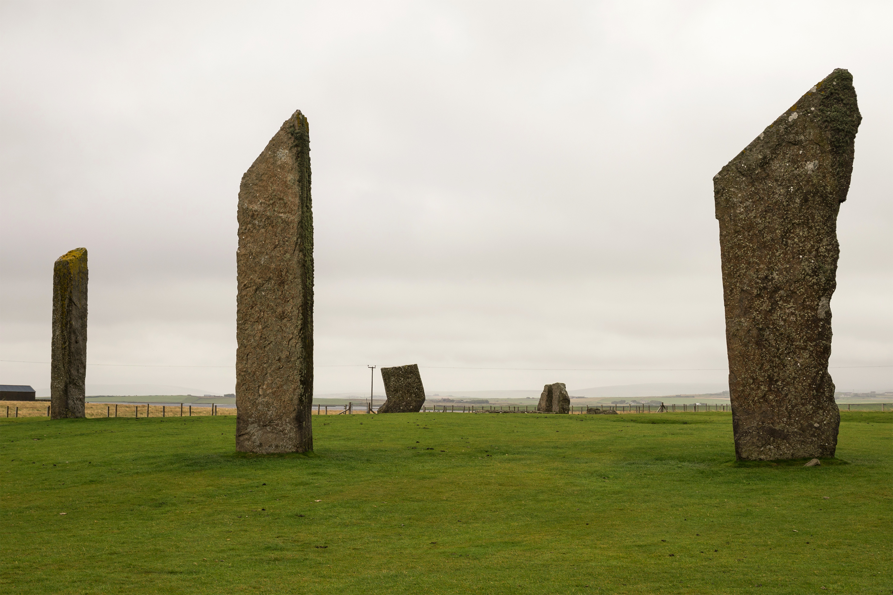
Maeshowe is located on the B9055 road on Mainland Orkney, between Stenness and Finstown. The Visitor Centre at Stenness is the starting point for all tours. The Stones of Stenness lie approximately 1.5 kilometres to the northwest. The Ring of Brodgar is approximately 3 kilometres northwest. The Barnhouse Stone, which aligns with the passage, stands 800 metres from the mound.
Maeshowe can be understood as a Neolithic architectural achievement, as a ceremonial space designed around astronomical observation, as a repository of Norse cultural expression, or as a place where the human relationship with death and cosmic cycles has been enacted for five thousand years.
Archaeologists consider Maeshowe the finest Neolithic chambered cairn in northwest Europe. The precision of the stonework, the scale of the construction, and the astronomical alignment indicate a society of considerable organisational capacity and technical knowledge. The monument gives its name to the Maeshowe type of chambered cairn, found only in Orkney. The blocking stone's interior operation is interpreted as evidence of sealed ceremonies. The relationship between Maeshowe and the nearby Stones of Stenness, Ring of Brodgar, and Barnhouse settlement suggests a unified ceremonial landscape. The four massive buttress stones in the chamber corners have no apparent structural function, and their purpose remains debated.
No oral tradition survives from the Neolithic builders. Norse saga tradition, particularly the Orkneyinga Saga, associates the mound with storm-sheltering crusaders and psychological disturbance. Local Orcadian folklore treated the mound as a place of supernatural association, consistent with broader traditions across the British Isles and Scandinavia in which passage graves were regarded as entrances to the otherworld.
Some writers on sacred sites and earth energies regard Maeshowe as part of a network of astronomically aligned monuments in Orkney, interpreting the landscape as a unified ceremonial complex designed to connect earth and sky. The passage grave tradition more broadly has been interpreted as creating gateways between the world of the living and the realm of the dead, a symbolic function that the architecture of Maeshowe, with its transition from light to darkness and back, seems to embody.
Whether Maeshowe was primarily a tomb, a ceremonial chamber, or an astronomical observatory remains unresolved. The purpose of the four corner buttress stones, which serve no structural function, is unknown. Few human remains were found in the chamber; whether it was emptied before the Norse entry, or whether its primary function was never burial, cannot be determined. The full meaning and context of the Norse runic inscriptions continue to be studied. The original height of the corbelled roof is uncertain.
Visit planning
Accommodation available in Stenness, Stromness (8 km), and Kirkwall (16 km). Range from hotels and B&Bs to self-catering cottages. Camping and caravan sites available on Mainland Orkney. The Orkney tourist season peaks in summer; book accommodation well in advance for midwinter solstice visits.
Follow your guide. Do not touch the walls or runes. Maintain quiet within the chamber. Be prepared to stoop through a low, narrow passage.
Outdoor clothing suitable for Orkney weather. Rain is common. The passage requires stooping; avoid bulky backpacks or rigid clothing that restricts bending. Comfortable, flexible clothing is practical.
Check with the tour guide. Flash photography may be restricted to protect the runic inscriptions and stonework. The chamber is dimly lit; cameras with low-light capability are useful.
Do not leave any objects inside the chamber or at the mound. The site is a scheduled ancient monument and any alteration is a legal offence.
Access by guided tour only. The entrance passage is approximately 0.91 metres high and 1.05 metres wide in its inner section. Those with claustrophobia, significant mobility issues, or inability to stoop for the passage length should enquire with Historic Environment Scotland before booking.
Plan your visit
Address
Maes Howe, Stoneyhill Rd, Stromness KW16 3HQ, UK
Hours
Hours, fees, and access can change — verify on the official source before you travel. Practical details last checked Jun 2026.
Nearby sacred places
Sacred places within a half-day’s reach. Pilgrims often visit them together: walk one, stay for the other.

References
Sources consulted when researching this page. Independent verification by readers is welcome.
- 01Maeshowe Chambered Cairn - Historic Environment Scotland — Historic Environment Scotlandhigh-reliability
- 02Maeshowe: History - Historic Environment Scotland — Historic Environment Scotlandhigh-reliability
- 03Maeshowe: Prices and Opening Times - Historic Environment Scotland — Historic Environment Scotlandhigh-reliability
- 04Maeshowe Chambered Cairn - Orkneyology — Orkneyologyhigh-reliability
- 05Maeshowe - World History Encyclopedia — World History Encyclopediahigh-reliability
- 06Heart of Neolithic Orkney - UNESCO World Heritage Centre — UNESCOhigh-reliability
- 07Maeshowe - The Ness of Brodgar Project — The Ness of Brodgar Projecthigh-reliability
- 08Maeshowe: Norse runes - The Ness of Brodgar Project — The Ness of Brodgar Projecthigh-reliability
- 09Maeshowe and the winter solstice - The Ness of Brodgar Project — The Ness of Brodgar Projecthigh-reliability
- 10The Winter Solstice in Historic Scotland - HES Blog — Historic Environment Scotlandhigh-reliability
Key questions
What pilgrims usually ask
- Why is Maeshowe Chambered Cairn considered sacred?
- Maeshowe is the finest Neolithic chambered cairn in northwest Europe, built circa 2800 BC with a passage aligned to the midwinter solstice sunset in Orkney.
- What should I wear at Maeshowe Chambered Cairn?
- Outdoor clothing suitable for Orkney weather. Rain is common. The passage requires stooping; avoid bulky backpacks or rigid clothing that restricts bending. Comfortable, flexible clothing is practical.
- Can I take photos at Maeshowe Chambered Cairn?
- Check with the tour guide. Flash photography may be restricted to protect the runic inscriptions and stonework. The chamber is dimly lit; cameras with low-light capability are useful.
- How long should I spend at Maeshowe Chambered Cairn?
- One hour for the guided tour. Allow additional time for the Visitor Centre, and a half to full day to explore the surrounding Heart of Neolithic Orkney landscape.
- What offerings are appropriate at Maeshowe Chambered Cairn?
- Do not leave any objects inside the chamber or at the mound. The site is a scheduled ancient monument and any alteration is a legal offence.
- What etiquette should visitors follow at Maeshowe Chambered Cairn?
- Follow your guide. Do not touch the walls or runes. Maintain quiet within the chamber. Be prepared to stoop through a low, narrow passage.
- What is the history of Maeshowe Chambered Cairn?
- Around 2800 BC, Neolithic communities on Mainland Orkney began constructing a monument of extraordinary ambition. They chose a site on the low ground between the lochs of Harray and Stenness, within a landscape already marked by ceremonial activity. They quarried flagstone slabs weighing up to thirty tonnes and fitted them with a precision that required no mortar. They built a passage eleven metres long, aligned to the southwest so that the midwinter sunset would penetrate its full length. They raised a central chamber nearly five metres square with walls rising in corbelled courses. They created three side cells, raised above the floor, to receive what they chose to place within. Then they covered it all with earth and stone, creating a mound thirty-five metres across and seven metres high, encircled by a ditch. The monument stood in its landscape for nearly four thousand years before it entered written history. The Orkneyinga Saga, composed in the thirteenth century, likely refers to Maeshowe in its account of Norsemen sheltering from a storm and being driven mad by the experience. In the twelfth century, Norse visitors broke into the chamber, possibly seeking treasure, and carved over thirty inscriptions in runes on the walls. They boasted, they declared love, they speculated about hidden gold. They carved a dragon, a walrus, a knotted serpent. In 1861, antiquarian James Farrer opened the mound, breaking through the roof of the entrance passage. His methods were crude by modern standards. George Petrie, the Orcadian antiquary who followed in his wake, recorded what he saw with greater care. Few artefacts were found: horse bones, a fragment of human skull, and the runic inscriptions that Farrer had uncovered. V. Gordon Childe returned in the 1950s to place the monument in its broader Neolithic context.
- Who is associated with Maeshowe Chambered Cairn?
- James Farrer, George Petrie, V. Gordon Childe